Learning Why We Liked Ike at the Dwight D. Eisenhower Memorial

Dwight Eisenhower’s life reflected the classic American success story. Born of humble origins, he chose an Army career in order to serve his country. Through his own talent, hard work and quiet ambition, he rose through the ranks to command one of the mightiest military forces ever assembled.  The victories achieved by that force would bring him worldwide acclaim. With the campaign slogan of I Like Ike, Eisenhower would go on to be overwhelmingly elected to two terms as President of the United States.

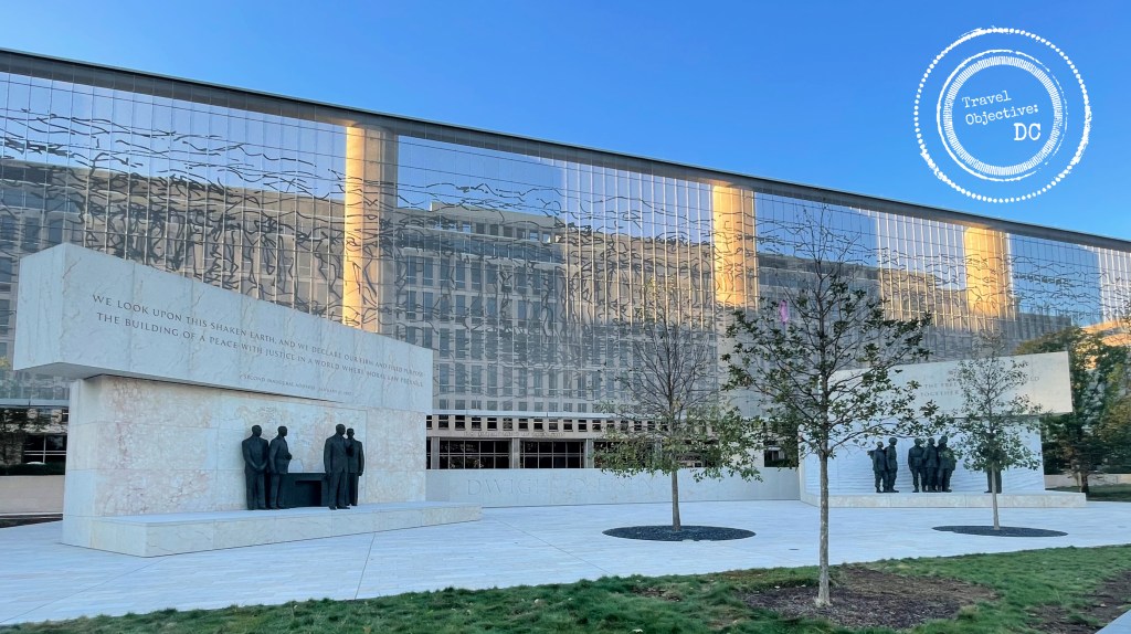
In 2020, a new memorial to Eisenhower was unveiled in Washington, DC. The monument’s designer, Frank Gehry, carefully researched his subject. He was so taken with Eisenhower the man, he wanted the memorial to emphasize not only Eisenhower’s accomplishments, but also his humanity and his interaction with others.  Unlike other presidential memorials, there is no large, neoclassical edifice. Rather, Eisenhower’s memorial is more akin to that of Franklin Roosevelt’s with statuary and scenes telling the story of the man and his times.

Located just off the National Mall, the memorial’s broad, open expanse forms a four-acre plaza between two Smithsonian Museums and several Federal office buildings. The memorial is composed of four central elements. Three elements portray Eisenhower, the person: as a young man, as Commander of the D-Day forces, and as President. The final element is a grand tapestry of stainless steel representing the Pointe du Hoc cliffs over the Normandy coast and covering the front of the Department of Education building. The space also includes trees, lawns, benches and two stone columns detailing Ike’s accomplishments.

The backdrop to the memorial is a 450 foot-wide woven wire tapestry depicting the cliffs of Pointe du Hoc in Normandy. On D-Day, US Army Rangers scaled the cliffs to prevent German artillery from firing on Allied troops landing on the beaches below.

As is often the case, work on the memorial took decades. Congress first authorized the Memorial in 2003 and Gehry’s designs were revised several times due to impassioned input from the Eisenhower family, historians and bureaucrats. While Gehry’s final work has not won universal acclaim, its central features invite the visitor to learn more about Eisenhower and the traits that not only made America “like Ike” but also made him such a pivotal figure of the 20th century.   

Born in Texas, Ike grew up in Abilene, Kansas where he and his five brothers were raised by hard working parents to value a strong work ethic, responsibility and education.

Eisenhower was proud of his origins and Geary thought it very important to include Ike’s image as a young man. The memorial shows a young Eisenhower, sitting in overalls and boots, looking off into the distance and imagining his future.  

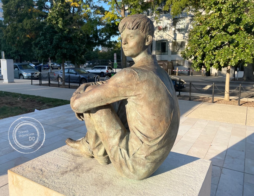
The statue of Eisenhower as a young man, imagining his future.

Perhaps to the dismay of his pacifist Mennonite parents, Eisenhower sought an appointment to West Point. Initially attracted by the free education, he proved a competent student, but a sometimes rebellious cadet who earned more than his share of demerits. He graduated in 1915 and chose to stay in the Army as a way of serving his country.

During World War I, Ike remained in the United States assigned to training commands. He studied the use of a new combat weapon, the tank. He gained valuable experience not only in armor tactics, but also military logistics, administration and training.

Army service during the two decades after World War I was challenging. The Army contracted quickly and defense budgets were small. Promotion was slow. Ike spent twelve years as a major, but stayed focused. He continued his professional development and was skillfully mentored by Major General Fox Conner.

Conner tutored Eisenhower on military history and operational matters. He also instructed his protégé on his principles for how democratic governments should wage war – Never fight unless you have to. Never fight alone. Never fight for long. Conner also emphasized his belief that a second “great war” was coming, and this time, the US Army would need to know how to fight as part of an international coalition.

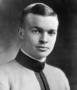
Dwight Eisenhower as a cadet at West Point.

Ike continued working hard, making himself indispensable to his bosses. He wanted them to miss him when he moved on to his next assignment. One of those bosses would be General George Marshall, the Army Chief of Staff who approved several promotions for Eisenhower and first sent him to London in June of 1942. Eisenhower would receive several more promotions as his responsibilities grew, overseeing Allied military operations in North Africa and Italy. As a commander of troops from other nations, not just the United States, Eisenhower mastered the balance and patience necessary to work with political leaders and diplomats as well as senior officers from other militaries.  President Roosevelt selected Eisenhower to be the Supreme Allied Commander in Europe in December 1943 with responsibility for the planning and execution of the invasion of France.

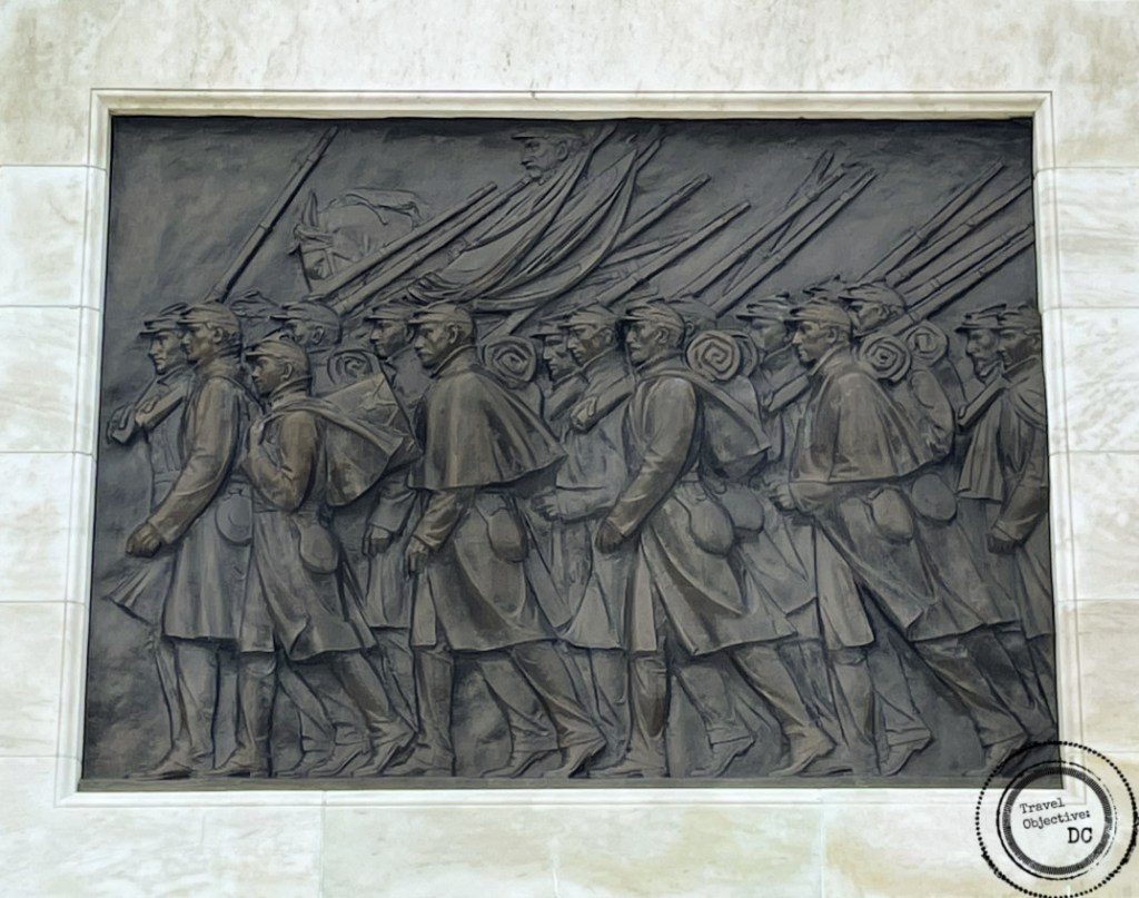
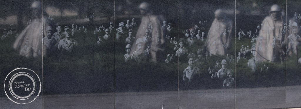
The memorial sculpture depicting Dwight Eisenhower as the commander of the D-Day invasion.

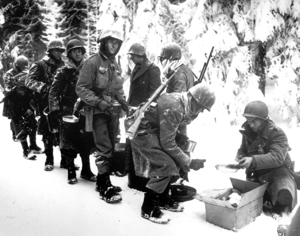
Through this all, Ike never lost his common touch with his soldiers. The memorial depicts Eisenhower as the D-Day commander speaking with paratroopers from the 101st Airborne Division, based on a real encounter the day before the invasion. Ike always took time to talk to soldiers. In addition to offering encouragement, he wanted to hear from them. He wanted to ensure they had been briefed on their mission, were properly fed and had all the equipment they needed.

This famous photograph of General Eisenhower speaking with paratroopers from the 101st Airborne Division inspired the World War II sculpture at the Eisenhower Memorial.

After the war ended, Ike held a series of high profile positions: Army Chief of Staff, President of Columbia University, and the first military commander of the North Atlantic Treaty Organization.  

In 1952, a “Draft Eisenhower for President” movement began to sweep the country. Americans were attracted to Eisenhower’s proven leadership. Over 25,000 people intent on drafting Eisenhower and proclaiming “I like Ike” attended a rally at Madison Square Garden.  He even won the New Hampshire primary before he declared his candidacy.

As a career soldier, Ike had initially eschewed politics. But he had concerns about a growing sense of isolationism in America. As the Supreme Allied Commander in Europe, Ike clearly understood the need to contain Soviet aggression with a strong military presence in Europe and through close cooperation with the European allies. He resigned from the Army and announced his candidacy for the Republican Party’s nomination for president. In November, he won a landslide election.

The memorial portrays Eisenhower as president, with three advisors, before a large map of the world.

The map emphasizes the central role global affairs played during Eisenhower’s tenure, which saw many global calamities, the Korean War, the Suez Crisis, and the Hungarian Revolution to name a few.  Through it all, Ike aggressively pursued peace. Already well known to international leaders, Ike was a reassuring figure on the world stage. He drew heavily on the skills he honed as a wartime commander: patience, careful planning, collaboration and the ability to balance the interests of many. Today the 1950’s are remembered as a period of relative calm, resulting from Ike’s success in navigating so many potential pitfalls.

Domestically, Ike governed as a moderate. He maintained FDR’s New Deal programs, maintained balanced Federal budgets, founded the Interstate Highway System and helped establish several different Federal agencies. (These agencies, or their successors, are present in the buildings surrounding the memorial, Health and Human Services, Education, the Federal Aviation Administration, and the National Aeronautics and Space Administration within the National Air and Space Museum.)   

Dwight Eisenhower’s official portrait as President of the United States in 1959.

As a political leader, Ike believed in moving gradually and keeping to the middle ground. One of the advisors depicted behind Eisenhower in the memorial is an African-American, which represents Eisenhower’s early success on civil rights. Some historians believe Ike’s approach limited progress on civil rights. Eisenhower did not write or speak very often on the subject. Nevertheless, he knew his responsibilities as president. The steps he took on civil rights, completing the racial integration of the Armed Forces, signing the first civil rights legislation since Reconstruction, and enforcing the desegregation at Little Rock High School more than matched his predecessors and set the stage for continued progress during the 1960’s.

Ike’s memorial is testimony to his biggest accomplishments on the beaches of Normandy and in the corridors of power in Washington, DC. Ike shaped much of the world we live in today, but how he did it is impressive as well. The values Ike demonstrated are timeless. It was decades of selfless public service, hard work, humility, integrity, and a belief in others that enabled his successes and endeared him so much to others. No wonder than that everyone “liked Ike”.

Nighttime at the Dwight D. Eisenhower Memorial

Route Recon

The Dwight D. Eisenhower Memorial is located across Independence Avenue from the Smithsonian Air and Space Museum. There is limited street parking in the area. This National Park Service website has a map with metered parking locations around the National Mall. Public transportation is the best option for reaching the Dwight D. Eisenhower Memorial, as well as the other monuments and museums that line the National Mall. The Washington, DC Metro system is conveniently located near the memorial. From the L’Enfant Plaza station, exit via Maryland Avenue & 7th Street; from the top of the escalator, the memorial is one block straight ahead.

The National Mall Circulator Loop bus provides access around the National Mall. The Dwight D. Eisenhower Memorial is a short walk from the Jefferson Drive and 7th Street SW stop on the National Mall route, or the D Street SW and 7th Street SW stop on the Eastern Market – L’Enfant Plaza route.

Capital Bikeshare is metro DC’s Bikeshare service, with 4,500 bikes and 500+ stations across the region, a number of which are located close to sites on the National Mall. There is Bikeshare station on 4th Street, just south of the Dwight D. Eisenhower Memorial visitor contact station.

Command Reading List

Many books have been written on Dwight Eisenhower’s life and career. Here are just a few:

Eisenhower: Soldier and President (The Renowned One-Volume Life) by Stephen E. Ambrose

Ambrose’s one volume edition focuses on Eisenhower’s most notable roles as president and D-Day commander.

Eisenhower in War and Peace by Jean Edward Smith

Smith reviews Eisenhower’s life in great detail from Kansas through the presidency, while examining how Ike’s different personality traits of hard work, dedication, intelligence, and the ability to get people working together propelled his success.

Crusade in Europe by Dwight D. Eisenhower

Prior to his presidency, Ike wrote this book to tell his own story of the strategies he followed, battles he fought and decisions he made to secure victory in World War II.

Additional Resources

You can access the audio guide to the Dwight D. Eisenhower Memorial here.

The Eisenhower Foundation has a series of informative videos about Dwight D. Eisenhower, his times and the memorial on their website.

Every Soldier Has A Story At The National Museum of the US Army

Levi Gassett enlisted in the Northborough Minutemen at age 28 in April 1775. He answered the alarm on April 19 for Lexington and Concord, and would serve through the summer and fall in the American colonists’ siege of Boston. While on Dorchester Heights, an area of Boston on high ground with views of the harbor, Gassett took time to personalize his powder horn. He inscribed the date, the name Dorchester, made reference to the war and engraved pictures of trees and soldiers, leaving a short and very personal record of his service. His powder horn is now one of hundreds of artifacts on display at the National Museum of the United States Army that reveal intriguing stories of what it means to be an American soldier.   

The powder horn of Levi Gassett

Every soldier has a story is more than just a slogan here. Telling the stories of American soldiers, such as Sergeant Gassett, is the purpose, the reason, the rationale for this museum. It is a hallmark of how the museum goes about its mission, spread through eleven galleries over three floors.

The Army currently operates many museums in various locations on Army facilities around the world. Indeed, preserving its history has been an Army mission since 1814 when Congress passed a law directing both the Army and the Navy to “provide for the collection and preservation of flags, standards and colours…”.

A casting of a Buffalo Soldier, a sergeant from the 9th United States Cavalry Regiment. The faces and the hands for the castings were made from the likenesses of modern day US Army soldiers.

But this museum, sitting south of Washington, DC on Fort Belvoir, Virginia, is unique. While other Army museums preserve and convey the history of particular units, branches, posts or portions of the Army, this is the first museum to take a whole-of-Army approach and comprehensively tell some of the stories of the 30 million men and women who have donned the uniform of the U.S. Army, while also recognizing their service and sacrifices.  

Upon entering the museum, the black granite Campaign Wall dominates the gleaming white two-story entrance hall. Along the wall are listed the 191 separate campaigns that the U.S. Army has participated in since 1775. Across the ceiling are rows of colored glass panels depicting campaign ribbons represented on the Campaign Wall. Across the floor is a 21-foot wide inlaid seal of the U.S. Army.

A Civil War-era snare drum used to keep cadence as soldiers marched and relay commands.

From the Entrance Hall a corridor leads to the first floor galleries, where seven-foot tall steel pylons begin telling soldier stories. The pylons are all inscribed with a soldier’s name, portrait, and a brief account of their service in their own words. They represent all types of soldiers from all walks of life throughout the Army’s history. They greet the visitor, almost like an honor guard in formation, presenting themselves for inspection.

Entrance Hall of the National Museum of the United States Army at Fort Belvoir, Virginia

The corridor opens up to the Army Concourse which provides access to the seven first-floor galleries. Six of the seven are referred to as the Fighting for the Nation* galleries. These galleries describe how the Army has evolved through the experiences of individual soldiers, expanding to fight major conflicts, adapting new technologies and responding to or sometimes leading changes found across America. The seventh gallery is entitled The Army and Society, which illustrates the interactions between the Army and the broader American civilian population and its culture.

To complete the galleries, museum planners, curators, and designers scoured through the 580,000 available artifacts from the Army’s 247+ year history and selected approximately 1,400, which were then integrated with authentically detailed reproductions, maps, dioramas, life-like cast figures and other vestiges of Army life to produce some very eye-catching multi-media displays.

Electronic map of the General Defense Plan for Western Europe from the Cold War

The artifacts are not just weapons and uniforms, although there are many of those, but other objects such as musical instruments, mess kits, radios, surgical tools, books and other routine articles that were part of soldier experiences. A display found in most galleries is entitled A Soldier’s Load, which exhibits the gear, weapons and personal items a typical soldier would have used or carried through each conflict. Museum staff will periodically set up displays with reproductions, describing the equipment and allowing visitors to handle the items for themselves.

Cobra King, an M4 Sherman Tank, led the armored column which broke through German lines and relieved the 101st Airborne Division at Bastogne, Belgium on December 26, 1944 during the Battle of the Bulge.

Large artifacts, such as restored cannons, tanks, helicopters and jeeps are present as well. Taken in total, the artifacts provide a picture of what life was like for soldiers of all ranks and provide compelling context for the soldiers’ stories.

On the second and third floors are galleries devoted to rotating exhibits. One of these galleries is currently dedicated to the experiences of the Nisei Soldiers, the first generation of Japanese-American soldiers who fought valiantly during World War II.  Initially prevented from serving because of their Japanese origins, young Japanese-American men and women responded overwhelmingly once authorized to join the military. In 2010, Congress recognized the contributions of the Nisei, awarding them the Congressional Gold Medal for their outstanding achievements and service to the United States.

The travel bag owned by Sergeant Gary Uchida, a Nisea soldier of the 100th Infantry Battalion. He recorded his travels around Europe and North Africa on the bag.

A unique mixed-use space on the third floor is devoted to a permanent exhibit about the Medal of Honor, the nation’s highest military award. The display examines the Army version of the medal (the Navy and Air Force have their own versions), the history of the decoration and the circumstances under which it is awarded. Adjoining the exhibit space is a large, outdoor garden with a granite wall bearing the names of all the soldiers who have been awarded the Medal. Overlooking the museum’s grounds, the garden is a serene place to consider not only the selflessness and sacrifices of the Medal of Honor awardees, but on all of the many stories told throughout the Museum.

The Experiential Learning Center (ELC) allows visitors of all ages to experience some of the current technical skills required for today’s solders. Visitors in organized groups can then test these skills in a simulated response to a humanitarian crisis. A portion of the ELC especially designed for the younger visitors called Fort Discover explains about Army life by following the adventures of two Army mules, Spartacus and Buckshot. 

A diorama of modern day U.S. Army Brigade’s Tactical Operations Center

Additionally, the Museum hosts book talks, battle briefs, field trips and staff rides with authors and other speakers from the military history community.  Options for virtual participation in many of these events are also included.

Sitting on a quiet corner of Fort Belvoir, the Museum’s highly reflective steel exterior is meant to represent the Army’s strength and how the Army reflects American society. American society certainly has its controversies, and the Army does too. Descriptions of Mai Lai and Wounded Knee massacres, and what happened there, are depicted at the Museum. Some critics may argue they are not addressed comprehensively enough. However, they are included and invite further discussion among museum visitors as well as through the Museum’s educational program.

Officer’s gauntlets belonging to Colonel Joshua Lawrence Chamberlain, who commanded the 20th Maine Volunteer Infantry during the Civil War.

Museums serve many purposes. They inform, entertain, and educate their visitors. The National Museum of the US Army does all these things. It would be hard for even the most casual visitor to leave the museum without even a slightly better understanding of what it means to be an American soldier. But by telling soldiers’ stories and artfully displaying their artifacts, the Museum is also a place for reflection about service and sacrifice. It is a place for connection, to friends or to relatives from the present or past generations. It can also be a place to resolve, to reconcile and to heal.

If you have an interest in military history or have a personal connection to the Army–but especially if you do not–the National Museum of the US Army is well worth a visit.

The National Museum of the United States Army

* * *

Visit the National Museum of the U.S. Army website for more information about the museum and its educational programs.

Are you a current US Army soldier or veteran who would like to share stories about your experiences? The Army Historical Foundation established the Registry of the American Soldier to gather the stories and experiences of the entire Army community. More information is available at armyhistory.org/the-registries

Route Recon

The National Museum of the United States Army is located on a publicly accessible portion of Fort Belvoir, Virginia. The address is 1775 Liberty Drive, Fort Belvoir, VA 22060. (Please note that not all GPS systems may recognize the address. The Museum’s GPS coordinates are 38.7242806/-77.177874)

By Car:

If driving from Washington (traveling south)

Follow Interstate 395 South toward Richmond, VA. Merge onto Interstate 95 South. Take exit 166A toward VA-286 South/Fairfax County Parkway. Continue for 2.5 miles and turn left onto Liberty Drive.

If driving from Baltimore, Maryland (traveling south)

Follow MD-295 South, Baltimore-Washington Parkway. Exit onto Interstate 495 South/Interstate 95 South toward Richmond Va./Andrews Air Force Base. Follow signs for Interstate 95 South toward Richmond, VA. Take exit 166A toward VA-286 South/Fairfax County Parkway. Continue for 2.5 miles and turn left onto Liberty Drive.

If driving from Richmond, Virginia (traveling north)

Follow Interstate 95 North toward Washington. Take exit 166A toward VA-286 South/Fairfax County Parkway. Continue for 2.5 miles and turn left onto Liberty Drive.

By Metro:

On weekdays – The Franconia-Springfield Metro Station, on the blue line, is the closest station to the Museum. From Franconia-Springfield Metro Station, take Fairfax County Connector Bus Route 334, which includes a stop at the Museum. Please note: Bus Route 334 is available Monday-Friday only and does not currently operate on the weekends.

On weekends – The Huntington Metro Station, on the yellow line, is the next closest station to the Museum. From Huntington Metro Station, take Fairfax County Connector Bus Route 171, which includes a stop at the Museum. Please note: Bus Route 171 only stops at the Museum on the weekends.

By Bus: The Fairfax Connector bus service travels to the Museum via two different routes:
Route 171 : Weekends ONLY
Route 334: Monday – Friday ONLY
Please check the Fairfax County Website for the most current bus schedules.

Mess Call

The Army Historical Society manages the Museum Café, which offers a selection of grab-and-go items, boxed lunches and grilled entrees along with beverages and other snacks. Museum visitors can order through a quick access app or via the web. Café hours are 9:00 AM to 2:00 PM.

* Fighting for the Nation Galleries

Founding the Nation – Traces the Army’s origins from the earliest Colonial militias, through the formation of the Continental Army and into the War of 1812.  

Preserving the Nation – Considers the divided loyalties of Army soldiers and officers in the earliest days of the conflict to how the Army would expand, fight and win the Civil War. 

Nation Overseas – Introduces the early clashes of the 20th Century where the Army first deployed beyond the United States and the how the Army prepared for and fought in World War I.

Global War – Examines how the Army would quickly mobilize and fight to win a two front war against fascism.

Cold War – Discusses the wars in Korea, Viet Nam and the defense of Western Europe from the threat of invasion by the Soviet Union.

Changing World – Recounts the end of the Soviet Union, the Persian Gulf War, the attacks of September 11, and the wars in Iraq and Afghanistan.


Grant Immemorial

Ulysses S Grant Memorial | Washington DC

The sculpted face of Ulysses S. Grant looks across the National Mall with dispassionate determination. Around him a battle rages. A cavalry unit charges forward, an artillery detail hurries to emplace a cannon, infantry continue their forward march. Yet Grant, in his simple uniform and campaign hat, sits atop his war horse Cincinnati, looking forward, studying the situation and planning several steps ahead.

Such is the image portrayed in Washington, DC’s memorial dedicated to the Civil War General-In-Chief and 18th President of the United States. The memorial is located in Union Square, a plaza located just west of the U.S. Capitol grounds.

The move to commemorate Grant in Washington, DC began in the decade after his death in 1885, spearheaded by surviving veterans of the Union Army of the Tennessee. In 1902, Congress ultimately selected the ambitious designs of sculptor Henry Merwin Shrady and architect Edward Pierce Casey who envisioned a large multifaceted memorial in bronze and stone. 

A native of New York City and a graduate of Columbia University, Shrady took up art while recuperating from typhoid fever. Although Shrady had no formal training as an artist or sculptor, some of his early works earned him much acclaim. He focused on sculpture and studied anatomy very carefully in order to portray realistic figures in his statues. In 1901, he completed a famous equestrian statue of George Washington located in Brooklyn.

Men and horses advance in the statue entitled Calvary Charge, part of the Ulysses S. Grant Memorial.

After winning the Grant award, he engaged himself even more thoroughly in researching his subjects. He studied New York City Police Department horses. He examined Grant’s death mask. He observed military drills and exercises. He analyzed Civil War uniforms, weaponry and equipment to enhance the detail in his work. He drew upon his father’s recollections as a physician who attended to Grant in his final year. His architect partner, Edward Casey, was a veteran of the New York National Guard and lent some of his military experience to the project.

Shrady and Casey’s memorial dominates the Union Square area. The centerpiece statue of Grant, reaching 44 feet high, is one of the largest equestrian statues in the world. Two bronze bas-relief sculptures depicting advancing infantry adorn opposite sides of the statue’s pedestal. Four bronze lions on their own pedestals guard Grant’s statue adding a sense of majesty. The statues and pedestals sit upon a terraced marble platform about 240 feet from end to end. At both sides along that platform are additional bronze sculptures depicting the randomness and chaos of combat. 

An artillery detachment races to place a cannon in Henry Shrady’s statue Artillery at the Ulysses S. Grant memorial.

The sculpture known as Artillery presents a team of soldiers and horses racing to position a cannon. The guidon bearer has signaled a turn to the right, yet a bridle on the lead horse has broken and the horse continues to lunge forward. 

At the opposite end of the memorial, the statue entitled Cavalry Charge depicts cavalry troopers on the move.  An officer raises his sword ordering the advance, the buglar sounds the charge, a soldier bears the colors. Yet tragedy is about to strike as a trooper has fallen from his mount and will be trampled. Shrady is said to have portrayed himself as the ill-fated soldier. 

Shrady had worked relentlessly for twenty years on the memorial, undertaking some of the most ambitious and complex sculpting work of the time. He obsessed over every detail of the massive statues, each of which took years to produce and were some of the largest bronze castings of their time. Sadly, Shrady died about two weeks before the final dedication of the statue in April of 1922 commemorating the 100th Anniversary of Grant’s birth.

The face of the fallen trooper in the Cavalry Charge statue, said to be that of the sculptor Henry Shrady. The Grant Memorial project consumed twenty years of Shrady’s life.

Given the interest both Shrady and Grant had in horses, it is not surprising how prominent they are in this memorial. This seems fitting as Grant was an accomplished rider and horseman.

Grant learned to care for and work with horses as a young man growing up in Ohio. His father was a well-connected businessman who secured his eldest son an appointment to West Point. Grant was not especially enthused about attending the military academy, but knew it was likely his best opportunity for a university education. 

Ironically, it was an accident of paperwork at West Point that he got his name Ulysses Simpson Grant. He was born Hiram Ulysses, but his Congressman wrote Ulysses Simpson (his mother’s maiden name) on his appointment documents. When he reported to West Point in 1839, he was told the appointment was for Ulysses Simpson Grant, so he assumed the name, rather than reapplying. 

 He was a capable, but unambitious student who graduated in the middle of his class in 1843.   

Originally thinking he might go on to teach college math, Grant decided on a military career following his service in the Mexican-American War. During the war, Grant was recognized several times for his bravery in combat. He learned some important skills during his service in Mexico, developing a proficiency in military logistics, and witnessing the leadership styles of several commanders, including Zachary Taylor and Winfield Scott. 

Detail of the two artillerymen riding the wagon in the Artillery statue.

After the war, Grant found aspects of the peacetime Army difficult, especially the separation from his family. Unfortunately, he looked for solace in alcohol and developed a reputation as a problem drinker. That reputation followed him his entire life. He resigned his commission in 1854 and unsuccessfully pursued a string of civilian jobs, ultimately going back to work for his father in Galena, Illinois. 

Following the attack at Fort Sumter in April 1861, Grant was determined to return to military service. He sought and received a commission and the command of the 21st Illinois Volunteer Infantry Regiment. He restored discipline and effectively trained the unit to make it combat ready. A promotion to brigadier general followed in August 1861.  

A bronze bas-relief plaque of marching infantry soldiers on the pedestal of the Grant equestrian statue.

In February 1862, Grant led his troops to successful engagements at Fort Henry and Fort Donelson in western Tennessee. His successes gave the Union some badly needed victories. They also gained him the nickname “Unconditional Surrender” Grant, because he demanded his enemies surrender without terms. His actions led to his promotion as a Major General of volunteers and he was appointed commander of the Army of the Tennessee.  

In April 1863, Grant’s army was attacked by Confederate forces; the resulting fight at the Battle of Shiloh made plain the painful truth that a long war awaited both sides. The losses were staggering, a combined 23,000 causalities. But Grant’s deft leadership in sustaining the rebel assault and successfully counterattacking led to a Union victory. Grant received criticism for being unprepared for the Confederate attack; some even calling for his removal.  Lincoln famously responded “I can’t spare this man, he fights.”

After Shiloh, Grant and his Army pushed further south from Tennessee, aiming to take the Mississippi River port city of Vicksburg, a vital logistics hub for the Confederacy. Grant would demonstrate strategic prowess in this campaign, coordinating his troop’s movements with the Navy, splitting his forces to fend off a rebel reinforcement, and ultimately accepting the surrender of Vicksburg and its 30,000 Confederate defenders on July 4, 1863 after a 48-day siege.  

In October 1863, Grant was given command of all Union armies in the West. He moved quickly to break a Confederate siege of a Union Army in Chattanooga, Tennessee. His success led Lincoln to appoint Grant to the rank of Lieutenant General (the first officer to hold this rank since George Washington) and as General-in-Chief of the Armies of the United States in March 1864.

As General-in-Chief, Grant provided Lincoln with a campaign plan for a multiple front operation wherein Federal Armies would pursue the remaining major Confederate formations and degrade the South’s ability to wage war.  

Through the spring of 1864 and into 1865, Grant would accompany General George Meade and the Army of the Potomac, engaging in a brutal campaign which ultimately lead to the surrender of Robert E. Lee at Appomattox, Virginia on April 9, 1865. 

Ulysses S. Grant at his Cold Harbor, Virginia Headquarters in June 1864.

-Civil War Photographs, 1861-1865, Library of Congress, Prints and Photographs Division.

After the war, Grant would serve as Secretary of War under President Andrew Johnson. In 1868, he was elected president and served two terms. Unfortunately for President Grant, although he was personally honest and upright, those around him were not and his administrations were tainted by corruption. Still, there were several notable accomplishments during his administration such as the ratification of the 14th Amendment, passage of early civil rights legislation, establishment of the Department of Justice, and the creation of Yellowstone National Park.

Despite the scandals, Grant remained very popular. Like Washington, he chose not to run for a third term. He left office, and embarked on a grand tour of America and the world. His later years proved quite difficult. An unscrupulous investor took advantage of Grant and he lost much of his money in bad investments. He was diagnosed with throat cancer in 1884. Wanting to leave his wife with sufficient means to support herself, he worked tirelessly up to his death to complete his memoirs.  When the Personal Memoirs of U.S. Grant was finally published, it was a major success, heralded by critics, historians and the public alike.

Grant died on July 23, 1885 in upstate New York. Over a quarter of a million people viewed his funeral train as it traveled down the Hudson River valley to New York City. Tens of thousands of Union Army veterans accompanied Grant’s casket in a procession sometimes seven miles long. Confederate generals Joseph Johnston and Simon Buckner were among his pall bearers. 

For a time, Grant’s legacy suffered from debatable stories related to his drinking, supposed indifference to losing soldiers in combat and scandalous presidency. Over the past several decades though, historians and scholars have more closely examined Grant’s characteristics as a strategic leader, effective manager, and skilled tactician.

Like Grant’s reputation, his memorial in Washington, DC has also undergone refurbishment over the past few years. In 2011, the Architect of the Capitol accepted responsibility for the memorial from the National Park Service and began to restore the statuary and stonework. Signs of corrosion and weathering were removed, the marble and bronze polished, missing or broken features from the statues, such as swords and chains, were replaced. Eight ornate bronze lamps were also installed around the memorial.  

Portrait Photograph of President Ulysses S. Grant, circa 1870

-Matthew Brady; Library of Congress Prints and Photograph’s Division

At the top of that memorial, as the face of General Grant gazes west, he can see the memorial to his wartime president, Abraham Lincoln. Through the Civil War years, Ulysses Grant and Abraham Lincoln developed a close working relationship. The two were westerners with a common touch and similarly humble origins. Lincoln appreciated Grant’s leadership, his willingness to maintain the offense and his sense of responsibility. Grant wrote: “No general could want better backing for the president was a man of great wisdom and moderation.” Now their memorials bookend our National Mall, a fitting testimonial to the president and his general who fought so hard to preserve the Union.

Route Recon

The Ulysses S. Grant Memorial is located along First Street, NW, just to the west of the U.S. Capitol building. The best way to get to the memorial (and the Capitol) is by taking Metro.

Three Metro stops are within walking distance of the memorial and the Capitol:

  • Union Station – Located at First Street, NW, and Massachusetts Avenue.
  • Capitol South – Located at First Street between C and D Streets, SE.
  • Federal Center, SW – Located at the southwest corner of Third and D Streets, SW.

Additional information on riding Metro, is available at the Washington Metropolitan Area Transit Authority.

The DC Circulator, a public bus system with routes through Washington’s downtown area includes stops near the Memorial. Find more information about Circulator busses at www.dccirculator.com.

There is very little public parking available near the Capitol. The nearest public parking facility is at Union Station, to the north of the Capitol. Very limited metered street parking is found along the Mall to the west of the Capitol.

Command Reading List

Many books have been written on Ulysses S. Grant. The below works offer new insights into Grant’s character and leadership.

Grant by Ron Chenow

Noted biographer covers Grant’s entire life and career, from his Ohio childhood through his presidency and beyond.

The Presidency of Ulysses S. Grant by Charles Calhoun

This book by historian Charles Calhoun produced a very comprehensive analysis of the Grant presidency, with detailed research that challenges some of the early criticisms of Grant which are often repeated by historians and biographers.  

The Personal Memoirs of Ulysses S. Grant, edited by John F. Marszalek with David S. Nolan and Louie P. Gallow

Grant’s memoirs were immensely popular when published in 1885. This annotated version provides extensive background and context to Grant’s original writing.

* * *

Fort Ward, the Mission Continues

Six Civil War reproduction cannons stand as silent sentinels over the Fort Ward Museum and Historic Site, an open and inviting space in Alexandria, Virginia, Washington, DC’s neighbor to the south. The site, located in Alexandria’s Seminary Hill neighborhood, was originally conceived as a Civil War era preservation project. Today, Fort Ward is embracing over 150 years of history, from the Civil War through the Civil Rights era, for this prominent and storied Virginia city.

Fort Ward’s origins are found in the days following the rebel victory at Manassas in July of 1861.  U.S. Government leaders quickly realized the Federal capital was in a precarious situation. Bordered on one side by Virginia, now enemy territory, and the other by Maryland, a slave holding state, Washington, D.C had almost no physical defenses to rely on.

Cannon - Fort Ward - Alexandria VA - Civil War defenses

The Army appointed one of its leading engineers and an expert on coast artillery, John Barnard, to design a robust defensive system along the high grounds surrounding Washington to guard strategic waterways, roads, railways and bridges. By the end of the war, Barnard’s extensive efforts lead to the construction of 68 forts and 93 gun batteries bristling with over 800 cannons and connected by various roads and trenches. Fort Ward is one of the best preserved examples of Washington’s Civil War defenses.  

Construction of Fort Ward began in July 1861 and was completed about two months later to protect the main approaches into Alexandria. The fort was named for U.S. Navy Commander James H. Ward, the first U.S. Navy officer killed in action during the Civil War.

Civil War re-enactors - Washington DC - Civil War sites
Fort Ward hosts multiple living history events throughout the year.

Fort Ward was built as a bastion fort, meaning the walls were designed at angles to provide interlocking fields of fire from inside the fort. Like most of the other fortifications, Fort Ward was constructed primarily of readily available dirt which was much better at withstanding artillery and rifle fire than brick, stone or wooden logs.  The earthen walls were approximately 20 feet high and 12 feet thick. The fort was expanded several times during the war. Ultimately, Fort Ward had five bastions with emplacements for 36 guns and a final perimeter almost half a mile long.  

A trench ran along that perimeter, a final obstacle for any attackers who might make it through the cannon fire. Units from Connecticut, New York, Pennsylvania and Ohio garrisoned the fort, usually numbering between three to four hundred men at a time.

Alexandria VA - Fort Ward - park - Civil War

The trench or dry moat surrounding the earthen bastion walls presented one more obstacle for any attacking forces.

Just after Virginia seceded from the Union in April 1861, the Union Army moved quickly to occupy Alexandria.  The city soon became a hotbed of Federal activity. Given its port and railroad connections, Alexandria became a logistical center. Troops and supplies would flow through the city. Wounded were transported to Alexandria for treatment and recovery. The city was filled with Army camps, warehouses, supply depots, hospitals and other official activities. This substantial U.S. Government presence attracted African Americans from around Virginia and beyond. Referred to at the time as “contraband,” these men and women came seeking freedom from slavery. They found paid employment at these Federal facilities, including Fort Ward. Many men enlisted in the U.S. Colored Troops regiments and went to fight.

At war’s end, when the Army left Fort Ward, several African American families remained. They purchased property and began building homes, churches and a school. Over four generations, the African American community continued to grow in its own neighborhood known as “The Fort”. The nearby Virginia Theological Seminary (which gives the current neighborhood its name) and Episcopal High School employed many of The Fort’s residents.

In the 1950s, the City of Alexandria began planning for the restoration of the original Fort Ward and the creation of today’s park space. Unfortunately, this work would lead to the resettlement of The Fort neighborhood. The city bought or appropriated the land compelling the families living there to move on. Archeological excavations of the original Fort Ward began in 1961. Renovations of several portions of the fort followed as part of the Civil War centennial.  The park was formally opened to the public in May of 1964.   

Fort Ward Museum, Alexandria, Virginia
The Fort Ward Museum, designed with a board and batten style commonly used around Washington during the Civil War period.

For a chronological view of Fort Ward, a visit today is best begun in the museum, housed in a reproduction two-story building modeled after a period Army headquarters building.  Museum curators have assembled an impressive collection of weapons, uniforms, documents, photographs, medical instruments, folk art, and other implements of military life to tell the stories behind the Civil War defenses of Washington, the history of Fort Ward, conditions in Alexandria at the time and the lives and duties of Union Army officers and soldiers.  A scale model of the original Fort Ward orients the visitor to its Civil War era layout and appearance.

The museum’s upper floor houses a research library containing a trove of historic materials as well as more contemporary documents and publications on the Union forts defending Washington, DC and other Civil War topics. The museum periodically organizes living history events, hosting Civil War reenactors at Fort Ward to enhance visitors’ understanding of the way soldiers and civilians lived their wartime lives.

Civil War - Officers Quarters - Hut
The Officer’s Hut provides a glimpse into how officers lived at Fort Ward.

Adjacent to the museum is a reproduction officer’s hut. Huts such as these were built to provide housing for Fort Ward’s commissioned officers. Peer through the windows and see the furnishings and accoutrements illustrative of how these officers lived at the time.

The museum and officers’ hut buildings are located on grounds outside of the original fortifications in what was a support area where troop barracks and living quarters were located, and administrative and logistical functions performed. 

Fort Ward - main gate - Alexandria, VA
The reproduction main gate at Fort Ward.

Pass through the reproduction entrance gate to the fort’s original grounds and follow the trail to see what the reconstructed northwest bastion would have looked like in 1864. One of the more heavily armed strongholds of the original Fort Ward as it overlooked the busy Leesburg Pike (today’s State Route 7), the restored northwest bastion includes six gun emplacements along with the magazine and a filling room for ammunition.  

After visiting the reconstructed fort area, a path circles through the larger park with open green space, picnic areas, and an amphitheater. Along the way, descriptive signage explains aspects of The Fort neighborhood and the people who lived there. Existing features of the old neighborhood are emphasized, including several surviving grave sites.  

The Fort - Clara Adams - Gravesite

Clara Adams, a longtime leader in The Fort neighborhood, is buried on the grounds of the historic site. Among her many contributions, she donated land for the community’s African American School.

The City of Alexandria continues to expand the interpretation of Fort Ward’s history for today’s Alexandria residents and visitors alike. A series of interviews with former Fort residents provide compelling first-person accounts of life in and around The Fort. These interviews started in the early 1990’s and continue today. An archeological dig concluding around 2014 used ground radars to clarify the boundaries of known grave sites, identify previously unknown grave sites and unearth additional artifacts. The city also has plans and designs for new interpretive signage and markers, a Fort neighborhood exhibit to the museum, historic home floor plan displays from The Fort neighborhood, and other interpretive tools and techniques to more completely convey the multi-layered story of Fort Ward.

Fort Ward is unique among Washington, DC area historic landmarks and a worthy addition to any DC itinerary. It preserves an essential element of Civil War history, namely the defenses of Washington, while also examining the complex social and cultural impacts of that period on life in Alexandria over the century that followed. As important, its 45 acres of leafy parkland are a pleasant place for locals and visitors alike to spend a sunny afternoon.

Northwest Bastion - Fort Ward - Alexandria, VA
Reproduction cannons at the restored Northwest Bastion

Route Recon:

The Fort Ward Museum and Historic Site is located at:

4301 West Braddock Road
Alexandria, Virginia 22304

Phone: 703.746.4848

Fort Ward is approximately six miles south of Washington, D.C. Free parking is available for cars and buses.

From Washington, DC: Follow signs to Interstate 395 (I-395) south to Richmond. Take the Seminary Road East exit. At the fifth traffic light (at Alexandria Hospital) turn left onto North Howard Street. Follow North Howard to its intersection with West Braddock Road and turn right. The Museum entrance is on the left.

From Old Town Alexandria: Follow King Street west to Alexandria City High School, turn right on Kenwood Avenue. Turn left on West Braddock Road, and proceed about a mile. The Museum entrance is on the right. 

From I-95/I-495 (Capital Beltway): Follow road signs to I-395 North. Take the Seminary Road East exit. At the fifth traffic light (at Alexandria Hospital) turn left onto North Howard Street. Follow North Howard to its intersection with West Braddock Road and turn right. The Museum entrance is on the left.

From Dulles Airport: Take Dulles Access Road East to I-495 North (Capital Beltway). Follow road signs to I-395 North. Take the Seminary Road East exit. At the fifth traffic light (at Alexandria Hospital) turn left onto North Howard Street. Follow North Howard to its intersection with West Braddock Road and turn right. The Museum entrance is on the left.


By Metro Rail, then Bus: Take the Yellow or Blue Line to King Street Station. The AT5 DASH Bus  www.dashbus.com to Landmark stops in front of Fort Ward. Call (703) 370-DASH for bus schedules and information.

By Amtrak or Virginia Railway Express: Walk across the street from the Alexandria Union Station to the King Street Metro Station to take the AT5 DASH Bus.  

More information about Fort Ward and how to plan your trip can be found at the Fort Ward Museum and Historic Site website.  

Walking Manassas

On a hot, humid Sunday in July 1861, soldiers from two newly organized armies, one Union, and the other Confederate met on the rolling hills and lush green fields north of Manassas Junction, Virginia, along the Bull Run creek. Those two landmarks would lend their names to this first seminal battle of the American Civil War.  Each side expected quick success over the other, boosted by the belief that attributes such as pride, honor, loyalty or the righteousness of their cause would bring triumph.

Today, the ground where they fought is preserved at the Manassas National Battlefield Park. Located just 25 miles west of Washington, DC., the park carefully conserves eight square miles of the battlefield amidst the development of Northern Virginia.

The Bull Run runs from north to south along the eastern portion of the park. Confederate forces set up defenses on the western side of the creek to defend Manassas Junction.

While key landmarks around the battlefield are, of course, accessible by car, a more interesting option is to explore the battlefield on foot. Walking the ground soldiers once trod and experiencing the terrain adds a certain depth to the facts gleaned through books and articles. Insights into leaders’ decisions become evident and battlefield stories come to life.

The National Park Service maintains several loop trails through the preserved areas of the battlefield.  The trails are of various lengths and signage provides historical context to the many sites encountered along the way. The NPS provides an excellent trifold map, available at the visitor center or on the park’s website, which can help you select the right trail for you based on your interest and level of comfort walking the sometimes hilly terrain.  At 5.3 miles, the First Manassas Trail provides the broadest perspective to the battlefield and the events of that momentous July day.

The trail begins at the park’s Henry Hill Visitor Center, which should certainly be the first stop for any new visitor. The well-appointed center houses a small theater, museum and a map with twinkling lights depicting the troop movements around the battlefield. National Park Rangers also offer very informative interpretive lectures daily explaining how these two quickly assembled armies would come to meet on this hallowed ground.

Exiting the visitor center, the trail cuts across adjoining Henry Hill, past a statue of the Confederate General Thomas “Stonewall” Jackson. It was during this battle that Jackson received his famous moniker. As Jackson was preparing for the defense of Henry Hill, another Confederal general, Bernard Bee, likened Jackson to a stonewall and instructed his troops to join with Jackson’s Virginia brigade. A monument to General Bee, who was killed at the battle, stands nearby. The trail continues along Henry Hill and crosses the “Reinforcement Road” a feint trail used by some Southern reinforcing units to reach Henry Hill during the battle.

The statue of Thomas “Stonewall” Jackson on Henry Hill dates from 1940.

To boost his forces, the Confederate commander, Pierre Gustave Toutant (PGT) Beauregard worked closely with his counterpart, General Joseph Johnston, who commanded a sizable Confederate force west of the Blue Ridge Mountains in the Shenandoah Valley.  To support Beauregard at Manassas, Johnston skillfully moved his forces from Winchester, Virginia to Manassas, using the railroad to quickly cover ground. Johnston set up his headquarters at a plantation to the southeast of the battlefield and allocated his troops for Beauregard to deploy and maneuver during the battle. Their collaboration was instrumental to the rebel victory.

PGT Beauregard commanded Confederate forces at the First Battle of Manassas. General Beauregard was a native of Louisiana, and the Confederate hero of the assault on Fort Sumter.

Photo By Mathew Benjamin Brady – This media is available in the holdings of the National Archives and Records Administration, cataloged under the National Archives Identifier (NAID) 525441., Public Domain, https://commons.wikimedia.org/w/index.php?curid=1197391

After traversing Henry Hill, the trail then moves through a hardwood forested area and then into an open meadow before crossing a busy road known as the Warrenton Turnpike during the Civil War, but known today as U.S. Route 29. After crossing the highway, follow the trail uphill, pass the ruins of a farm and then turn west, descending along a ridge overlooking the famous Stone Bridge.

The bridge figured prominently into the events on the day of the battle. With rebel forces taking up positions on the western side of the Bull Run to defend the transportation links at Manassas, the Union plan was to outflank Beauregard on the left edge of his line, which was situated on the ridge overlooking the the bridge.

The Union army commander, General Irvin McDowell ordered a diversionary attack commencing at 5:30 that morning on the rebel forces holding the end of the line. Meanwhile his main force would cross the Bull Run further to the northwest.

Today’s Stone Bridge dates from the 1880s. The original Stone Bridge was destroyed by Confederate troops in 1862.

A Confederate signal station observed these troop movements and warned Confederate Colonel Nathan Evans, who commanded two regiments on the Confederate left. After receiving the warning of the flanking maneuver, Evans ordered most of this troops away from the ridge to Mathews Hill, further west of his position, leaving four companies of South Carolina militia. Evans redeployment of those troops proved essential and would shape the later battle.

After passing the Stone Bridge, the trail runs along a segment of the Bull Run. Although not particularly deep nor wide, the creek’s banks are quite steep, which made access to shallow fords with level banks of importance to both armies.

Leaving the Bull Run, the trail turns west and continues through fields and wooded areas. During the time of the battle, farms and plantations predominated in the area and the land was largely cleared of trees and brush opening up fields of fire and making it easier to observe troop movements. Interpretive signs and weathered stone markers dot this portion of the trail, providing the hiker additional background on troop movements and conditions on the day of the battle.

General Irvin McDowell commanded the Union Forces. More experienced in military administration than command, McDowell understood his troops were green, but there was significant political pressure on him to act.

Photo from the Brady National Photographic Art Gallery (Washington, D.C.)

The trail emerges from the woods onto the open terrain of Mathews Hill. From its high ground, scenic vistas looking south and west give an excellent view of major portions of the battlefield. Across the open terrain are clear views of Henry Hill and the visitor center. U.S. Route 29 cuts across and seemingly bisects the landscape.

The view of Henry Hill with the Henry House and Visitors Center from Mathews Hill.

Mathews Hill was the site of significant fighting in the next phase of the battle. Evans’ dispatched troops from the Stone Bridge took up a defensive position on this hill and by 10:30 that morning were encountering the first wave of Federal troops who had crossed the Bull Run further to the north of the Stone Bridge. The rebels fought stubbornly against a strengthening Federal force. Several Confederate regiments arrived to reinforce Evans’ troops. But after several unsuccessful counterattacks and becoming badly outnumbered, the Southerners withdrew from Matthew’s Hill.

Making a critical error that would later cost him the battle, General McDowell did not immediately pursue the rebels as they retreat toward Henry Hill. A delay of over an hour allowed Southerners to organize defensive positions, as their reinforcements continued to arrive from Manassas.  

Leaving Matthews Hill, the final mile of the trail begins a slow decent, past the landmark Stone House, across U.S. Route 29 and then up Henry Hill, site of the battle’s fateful culmination. More of a broad plateau than a hill, Henry Hill was named for the Henry Family farm which occupied the area during and for many years after the battle.

Prominent on Henry Hill is the Henry House. The original house was damaged during the battle and its inhabitant, Mrs. Judith Carter Henry, was killed. The current house was rebuilt after the Civil War by the Henry Family.

The ensuing artillery fight turned into an infantry battle as Union and Confederate regiments arrived, attacking and counterattacking in the vicinity of the cannons.  Buoyed by fresh troops which continued to stream in from Manassas and with numbers now on their side, the Southerners would take the upper hand forcing McDowell’s army to retreat around 4:00 pm and begin a long and sometimes chaotic march back towards Washington.

After the battle, the casualty counts conveyed the bloodiest day in American history, up to that time. The Federal Army suffered the loss of 460 soldiers and over 1,000 wounded and another 1,300 captured or missing. Southern losses were less, but still alarming with 387 killed and about 1600 wounded.

Both sides began to understand victory in this war would be neither easy nor quick.  Many more battles would follow. Indeed, in a little more than a year, the armies would once again return to these fields to fight an even bloodier battle. 

Route Recon

Manassas National Battlefield Park is located about 25 miles west of Washington, DC.

If you are using a GPS device, the mailing address of the Henry Hill Visitor Center is:

6511 Sudley Road, Manassas Virginia 20109

From Washington D.C. and Points East: Travel west on Interstate 66 to Exit 47B, Route 234 North, Sudley Road. Proceed through the first traffic light. The entrance to the Henry Hill Visitors Center is on the right, just past the Northern Virginia Community College.

From Points North: Travel south on I-95 to the Capital Beltway, Interstate 495. Travel west towards Silver Springs, Maryland. Continue on the Beltway for approximately 10 miles, crossing the Potomac river into Virginia. Take the exit for Interstate 66 west to Manassas. Take Exit 47B, Route 234 North, Sudley Road. Proceed through the first traffic light. The entrance to the Henry Hill Visitors Center is on the right, just past the Northern Virginia Community College.

From Points South: Travel north on Interstate 95 to Exit 152, Route 234. Turn left at the traffic light on to Route 234 North, Sudley Road. Stay on Business Route 234 (do not take the by-pass) and travel for approximately 20 miles just beyond the city of Manassas. The entrance to the Henry Hill Visitors Center is located on the right, just past the entrance to the Northern Virginia Community College.

From Points West: Travel east on Interstate 66 to Exit 47, Route 234 North (Sudley Road). Turn left on Route 234 and proceed through the first traffic light. The entrance to the Henry Hill Visitors Center is on the right, just past the Northern Virginia Community College.

Unfortunately, there is no public transportation to the park.

Safety Briefing

Be aware of the following before you start your hike:

The trail can be moderately strenuous and muddy in a few portions, so proper footwear is important. 

Many trails, both official and unofficial, intersect the main hiking trails, so it is important to use either an electronic or paper map and be mindful of your location. Follow trail blazes appropriate for your trail, blue blazes indicate a hiking trail and yellow blazes indicate horse trails.

Bring plenty of water.

Beware of ticks! Stick to the trail. Insect repellent is recommended.

In the event of an emergency on the trail, call 911 from your mobile phone.

Should you see an object of potential historic significance, please leave it in place and notify the park staff at 703-361-1339 x0.

Pets are permitted on all park trails but must be kept on a leash no longer than 6 feet.

When Life Saving Was its Own Service

Long ago, solitary figures walked deserted American beaches at night, scanning the horizon looking for signs of a ship in distress and examining the beach closely for evidence of a ship wreck. Regardless of weather, they continued on their paths, undeterred, for these were not just any men. Indeed, they were the surfmen of the United States Life-Saving Service (LSS). 

In the late 19th and early 20th centuries, the LSS had stations along all three coasts has well as the shores of the Great Lakes. North Carolina would eventually have a total of 29 stations.  

A visit to the Chicamacomico (chi-ki-ma-COM-i-co) Life-Saving Station in the beachside community of Rodanthe, North Carolina provides an insightful introduction to the brave men of the LSS and the times in which they lived. Established in 1874, Chicamacomico is one of the few remaining stations still largely intact and open to the public.

Organized maritime lifesaving in the U.S. began in Massachusetts in the 1780s, but would remain a largely private, voluntary activity for almost a century. It was not until after the Civil War, as commercial shipping grew along with the U.S. post-war economy that Congress established the LSS in 1871. Lifesaving crews would be now paid and equipped by the Federal government. 

LSS Surfmen’s dress jackets, still ready for service, hang in the 1911 Life-Saving Station Building.

The new service was placed under the jurisdiction of the Revenue Marine Service, within the Department of the Treasury. Officers from the Revenue Marine Service began building the new organization, establishing a personnel system, writing procedures, developing training, and procuring equipment. The first lifesaving stations were established in New Jersey, but by 1874, lifesaving stations were being built all along the U.S. Atlantic and Gulf coasts. At the end of that year, seven life-saving stations, including Chicamacomico, would be built on the Outer Banks of North Carolina, where they were very much needed.  

The Outer Banks, a string of sandy islands running along the state’s Atlantic coast, are near the confluence of two strong ocean currents. The warm Gulf Stream runs to the north and intersects with the colder, south running Labrador Current. The churning waters where the currents meet create shoals or sandbars which are constantly changing size and shape. The mixing of the warm and cold waters also contributes to sudden and violent storms. The storms and shoals are hazardous by themselves. Together they have ensnared unsuspecting ships for centuries.  There are an estimated 600 ship wrecks beneath the waters today, some dating back to the 1500s.

The original Chicamacomico Life-Saving Station building, built in 1874.

These first live saving stations consisted of a single building, roughly the size of a small barn. The 1874 Station building at Chicamacomico is a rare example of these original Life-Saving Station buildings still in existence today. These buildings were constructed by local builders in accordance with an LSS-wide standard plan and designed for exposure to the harsh surf conditions. Weather resistant materials such as cedar shingles, pine weatherboards, and cypress or locust wood posts were used. While the station building design was simple, the buildings themselves were embellished with ornate carved wood trimmings in the cottage style.

The station building ground floor included two rooms. There was a day room, used by the crew for meetings, training and recreational activities and a large room where rescue equipment was stored. The upper floor contained additional equipment storage space, crew quarters and offices. Capping the building was an open watchtower where surf conditions and maritime traffic were carefully monitored by the station crew.

A shot cannon and “faking” box used for sending rescue lines to damaged or marooned ships. The intricate wrapping of the rope around the prongs of the faking box kept it from getting tangled.

Like other life-saving stations, the Chicamacomico station was staffed by a crew of seven: six surfmen and a commander known as a keeper. The keeper assumed overall command during the rescue operation, determining the overall plan, designating which apparatus would be used and directing the distressed ship’s captain and crew. Surfmen were numbered, with each position given proscribed duties during a rescue. The Number 1 Surfman acted as a deputy to the keeper. Keepers and surfmen came from the local community. As residents, they would have the best knowledge of local tides, channels and currents. Crews were expected to have experience working on the water and be in good physical condition.

A beach cart marked with the abbreviation for the United States Life-Saving Service. The cart would be loaded with equipment and pulled by surfmen (later by horses) from the station across the beach to the rescue site, which could be several miles away.

Examining some of the lifesaving equipment on display in the 1874 Station, it is clear why surf men needed to be in good shape. There is a blue beach apparatus cart which would be fully loaded with a wide range of equipment, a small canon to fire “shotlines” or rescue lines toward the ship in distress, additional ropes, pulleys, a sand anchor to steady the cart once parked at the rescue site, a ‘faking box’ which kept the rescue lines free of tangles, shovels, and additional buoys as well as a variety of other gear. During a rescue mission, this cart loaded full of equipment would be pulled along the beach by the surfmen, who would then set up the equipment and begin their rescue mission.

Also on display is a rare example of a life car, a torpedo-shaped metal device that could hold up to seven passengers. The life car would be deployed using a heavy tow line and pulley. Once full, the life car would then be pulled back to shore. Because of their size and weight, life cars were not often used in North Carolina. A more commonly used lifesaving apparatus was the breeches buoy which consisted of a ring buoy with a trouser legs attached and connected to a system of ropes and pulleys. The person being rescued would put their legs through the trouser legs and keep the ring around their waste. The surfmen would then pull the person toward safety.

One of the few remaining life cars in existence today. After the widespread adoption of the breeches buoy for ship to shore rescues, life cars were still used to bring seriously injured sailors or small children to safety.

The most prominent item in the room is the 1911 Beebe-McClellan surfboat. The boat is made of white cedar wood and has special hatches to drain water from the inside. Surfboats were used when wrecks were beyond the reach of the shotlines and the surf cooperated. At 3,800 pounds empty, the surfboats also tested the physical strength and endurance of the surfmen. Like the beach apparatus carts, surfboats were pulled across the beach on carts by the surfmen, then manually rowed in high winds, heavy rains and pounding surf.

A simple quote from a long ago LSS Station keeper sums up the service’s mission very well. Displayed in slighltly different versions around the station exhibits, it simply says: “The book says ya gotta go out; it don’t say nothin’ ‘bout coming back”. 

To keep surfmen ready for this mission at all times, the LSS had a proscribed daily schedule for drills, equipment cleaning, maintenance, station upkeep, signaling practice and first aid training. The schedule was in effect when stations were staffed, which was originally from December through March. In the eastern U.S., stations would eventually be staffed for ten months, from August through May.

In this vintage photo, a U.S. Coast Guardsman wears a breeches buoy during a training drill. The breeches buoy was a very commonly used by surfmen during rescue operations. Photo: U.S. Coast Guard

Adjoining the 1874 station building is the Cook House, built in 1892. As was often the case at the time, kitchens were kept separate from the main living and working areas to mitigate the risk of fire. Today, the 1892 Cook House has displays on life saving station construction material and methods.

The LSS was never a stagnant organization as organizational change and technical innovation continued through the late 19th and early 20th centuries. Congress continued to expand the LSS’s budget, more stations were built, new rescue apparatus was fielded. Stations began receiving horses to pull the rescue equipment across the beaches and new surfboats equipped with motors.  

In 1911, a new and larger station building was erected at Chicamacomico, along with an expanded cook house. The new station layout had expanded space for the keeper’s office, sleeping quarters, and supply storage. Indoor plumbing and steam heating would later be installed (surely to the delight of the crew) along with a bathroom and a shower room. Today, most of these rooms house additional displays on the equipment, daily life, and daring rescues at Chicamacomico. 

The original main entrance to the 1911 Life-Saving Station building.

Climbing the ladder in the Surfmen’s Quarters Room leads to the third story watch tower where crew members kept a constant lookout over the ocean and the sound, tracking vessels plying the waterways and looking for signs of distress. From here, Surfman Leroy Midgett was standing watch on the afternoon of August 16, 1918, when he observed a large plume of water, followed by explosions about six miles to the southeast. He immediately notified the keeper, John Allen Midgett. The crew at Chicamacomico were about to embark on one of the greatest lifesaving rescues in United States history.

Surfman Midgett had spotted the British Tanker Mirlo, en route from New Orleans to England with 5,000 tons of gasoline and a crew of 51. At about 3:30 pm she was torpedoed by the German submarine U-117. Since America’s entry into World War I, German submarines patrolled the eastern seaboard to intercept Allied shipping bound for Europe. The North Carolina coast was especially favorable for submarine patrols as the Outer Banks were a natural maritime “intersection”. Ships traveling north would ride the Gulf Stream up the coast until the Outer Banks, before turning to the east for European ports.

Today’s view from the watch tower of the 1911 Life-Saving Station building, looking east toward the Atlantic Ocean, is different from what LSS Surfman Midgett saw while on watch the afternoon of August 18, 1918. Note the 1874 station building, cook house and cistern on the left.

The torpedo hit the Mirlo amidships. A series of resulting explosions eventually broke the ship apart. Gasoline poured into the water then ignited, trapping the wreckage in an inferno. The captain issued an order to abandon ship and the three available lifeboats were launched. Two lifeboats made it safely away from the Mirlo, but one overturned and six sailors clung to it for their lives.

Back on shore, Keeper John Midgett and his team needed several tries to launch the surfboat past the rough breakers crashing against the shore. Finally, they cleared the waves and headed for the burning remains of the Mirlo. Barrels filled with gasoline continued to explode, shooting burning gas into the sky, before it settled on the ocean surface, still aflame.  

Midgett and his crew encountered the first lifeboat with the British captain and 16 sailors aboard and directed the lifeboat to anchor off shore, rather than attempt to reach the beach on their own, as the breakers were too strong and the lifeboat would likely capsize. Midgett and his crew then continued toward the Mirlo encircling the wreckage in the fiery water.  They found an opening in the flames and were able to reach the capsized lifeboat. Singed by the flames, they rescued the six sailors who stayed alive by bobbing underwater to escape the heat and fires, emerging only for quick breaths of air.

Surfboat Number 1046, built in 1909 by the Bebe-McClellan Surfboat Company. This was the surfboat used by the Chicamacomico life savers during the Mirlo rescue.

Once the six sailors were safely on board, Midgett and his crew found the second, overcrowded lifeboat adrift and heading away from the shore.  They caught up to it, threw a tow line and proceeded to tow it back to the anchorage, where the Mirlo’s captain was still waiting.  Midgett then began relaying sailors into shore in the surfboat, where they were immediately taken by LSS surfmen back to the Chicamacomico station. By 9:00 PM, 42 sailors from the Mirlo had been rescued and safely brought ashore. Captain Midgett and his crew would receive decorations and awards from both the U.S. and British governments for their heroism.

Despite the repeated heroics of the LSS, the service was plagued with allegations of favoritism in the selection of keepers and surfmen.  Various proposals were made in Congress to move the LSS to another agency, such as the U.S. Navy. Ultimately, in 1915, Congress passed legislation merging the LSS with the Revenue Marine Service to form the U.S. Coast Guard. Civilian surfmen and keepers would now become military personnel, subject to military rules and regulations, but also receiving military pensions. In reality, the move changed little in the day to day lives of the lifesaving crew at Chicamacomico. They continued to train, drill, watch the shore and never failed to respond to a ship in distress.

Many members of the Midgett family served at Chicamacomico; a visitor to the area today quickly notices the prominence of the Midgett family name in the station’s history, as well as in the surrounding Outer Banks community. Adjoining the 1911 Station at Chicamacomico is the house of Keeper John Midgett’s brother Cornelius. He and is wife Daisy lived in the home for many years, before passing it on to their niece Wilma and her husband, who was also a Coast Guard officer stationed in the area in the 1940s. The house was moved to its current location in 2005 and is complete with furnished rooms and period pieces of the Midgett family.

The Midgett House provides a first hand look at early 20th Century life on the Outer Banks.

After World War II, the Coast Guard began to close the old life saving stations. The advent of the helicopter and other technologies began to change the nature of maritime rescues. The Chicamacomico station closed in 1954 and the land and buildings turned over to the National Park Service. In 1968, a group of Outer Banks residents purchased the land and buildings. Six years later, the Chicamacomico Historical Association was formed to continue the preservation and restoration of the site. The association continues to own and operate the site today, researching archives, curating displays, interpreting artifacts and preserving the history of the LSS for the 21st Century.

It is a history well worth preserving. In a little more than the 40 years of existence, the surfmen of the LSS, posted some impressive results, rescuing 177,286 imperiled sailors and passengers.  Because of these brave men, countless descendants of those rescued are with us today. But monuments and markers to the LSS are few. A visit to Chicamacomico honors the memory and sacrifices of those who knew they had to go out, also knowing they might not make it back.

* * *

Route Recon

The Chicamocomico Life-Saving Station is located on North Carolina Highway 12 at mile post 39.5 in Rodanthe, North Carolina. The address is 23645 NC Highway 12, Rodanthe, NC 27968.

Mess Call

Unfortunately, the cook’s houses at the Chicamacomico Life-Saving Station are no longer serving up hearty fare for hungry surfmen (or visitors for that matter). Fortunately, Lisa’s Pizzeria is! This local favorite is a great stop for pizza, fresh salads, tasty sandwiches and Italian specialities. It is located south of the Chicamocomico Life-Saving Station at 24158 NC Highway 12, Rodanthe, NC 27968.


Generals Stevens and Kearny at the Battle of Chantilly

“By God, I will support Stevens anywhere”.

So said US Army Major General Philip Kearny (pronounced CAR nee), when informed of Stevens’ need for reinforcements. General Kearny was referring to his fellow commander Brigadier General Isaac Stevens. The generals were division commanders within the Union Army of Virginia. It was September 1, 1862 and a fateful day for both men.  

Just two days earlier, the Union Army of Virginia, commanded by Major General John Pope, had been defeated by General Robert E. Lee and the Confederate Army of Northern Virginia at the Second Battle of Bull Run. Pope now wanted to move his force from its current location in Centreville, Virginia to the east and inside the defensive perimeter surrounding Washington, DC.  To make such a move, Pope needed to secure a key road junction in Germantown, Virginia (today known as Jermantown, a neighborhood within Fairfax, Virginia). Knowing he needed to move fast, lest Lee try to cut him off and continue the fight, Pope sent forces to secure the road junction.

Stonewall Jackson moved his forces (shown in red) down the Little River Turnpike towards Jermantown to cut off General Pope. Pope’s army (shown in blue) would use the Warrenton Turnpike to move east toward Jermantown and on to Washington, DC.

Lee was indeed seeking to draw Pope away from his Centreville location for a fight. He sent Major General Thomas “Stonewall” Jackson along the Little River Turnpike to Germantown, seeking to surround Pope. After Pope received reports of skirmishes with rebel units along the turnpike, he knew the rebels were on the move. Pope sent the IX Corps, which included General Issac Stevens’s First Division, to check and hold Jackson’s movement.   

A capable man, General Stevens had a unique career. A native of New England, he graduated first in his class at West Point and served in the Mexican-American War. An acquaintance and supporter of President Franklin Pierce, Stevens was named governor of the newly formed Washington Territory in 1853 where his tenure proved controversial for his use of martial law and relations with Native tribes. Nonetheless, he was elected as the Washington territory delegate to Congress in 1857.  

After the First Battle of Bull Run, Stevens was again commissioned in the Army and appointed as commander of the 79th New York Volunteer Infantry Regiment. The regiment was organized in New York City with the help of the St. Andrews society. Their uniform featured tartan patterns and took the nickname “Cameron Highlanders”.

Brigadier General Isaac Stevens

Photograph by Timothy H. Sullivan

Around 4:00 pm on September 1st, General Stevens observed rebel units covering Jackson’s main advance down the Little River Turnpike near an area known as Ox Hill. Artillery was deployed; Stevens organized his division and launched his attack through a cornfield, open meadows, and the surrounding woods. Jackson, caught by surprise, deployed his divisions as well, meeting Stevens troops with withering fire.

A remaining portion of the battlefield where Steven’s division attacked uphill.

As the troops engaged, a ferocious thunderstorm then swept over the battlefield, adding thunder, lightning, gale force winds and a downpour to the din and confusion of battle. Despite the fire and the storm, Steven’s division continued moving against the rebels. When the attack stalled, Stevens himself picked up the colors of his former regiment, the 79th New York and rallied his soldiers proclaiming “Highlanders, my Highlanders, follow your General”.   Stevens was killed almost immediately, but his troops pushed forward.  After some initial success, counterattacking rebels forced Steven’s troops back. 

“The Death of General Isaac Stevens during the attack on Chantilly, Virginia, 1862

Lithograph by Alonzo Chappel

It was about this time that Kearny’s division reached Ox Hill. Like Stevens, Kearny too had an unconventional career for a US Army officer, but one marked by bravery and extensive combat experience. Born into a wealthy New York family, he earned a law degree from Columbia College, but desired to serve in the military. In 1836, he was commissioned a 2nd Lieutenant of Cavalry and three years later was sent to France and studied at the French cavalry school at Saumur. 

He would return to the US where he distinguished himself during the Mexican American War, losing an arm during the Battle of Churubusco.  After the war and somewhat bored with peacetime service, Kearny resigned his commission and ultimately returned to France. There he served in Napoleon III’s Imperial Guard during the Wars of Italian Unification. He led a daringly successful cavalry charge at the Battle of Solferino and became the first American to earn the French Legion of Honor.  

Like Stevens, he too was again commissioned in the US Army in 1861, despite his amputated arm. 

General Philip Kearny

With the thunderstorm still raging, Kearny deployed his lead brigade to engage Confederates on the western edge of the Union line. Then riding forward in the center of the line and into the cornfield, Kearny sought to gather and organize a Massachusetts regiment to close a widening gap in the Union line. Riding in front of the troops to reconnoiter, he was warned Confederate soldiers were still present. He declared “The rebel bullet that can kill me has not yet been molded”.  Continuing on, he was killed by fire from a Georgia unit still occupying the cornfield. 

Now well past 5:00 pm, the daylight faded and dusk drew in.  With wet ammunition and unable to aim their muskets in the growing darkness, both sides resorted to hand to hand combat with fists, bayonets and rifle butts. Finally, with no light left, the exhausted and soaking wet soldiers withdrew within their lines.  Arriving Union units would hold the Federal line until the pre-dawn hours of September 2nd. Then all the Federal units departed from the battlefield to continue to move east towards Washington.

During the roughly two hours of fighting, approximately 1,500 soldiers were lost, including the two adept Union generals. The battle proved inconclusive. Confederates would hold the field the next day, but Jackson was unable to reach Germantown, and Pope successfully moved his army to Washington. Lee would regroup, then head west and begin his invasion of Maryland. 

What would become known as the Battle of Chantilly (or Ox Hill) occurred over approximately 500 acres of woods and fields in Fairfax County, Virginia. For a hundred years after the battle, the area remained largely rural.  The one-time owner of the farm on which a large portion of the battle took place, a Confederate veteran, ceded a parcel for the erection of monuments to persons or units who fought at the battle. Monuments to both Generals Stevens and Kearny were unveiled in 1915.

Stone memorials in Ox Hill Park to Generals Stevens and Kearny

As a suburb of Washington, DC, Fairfax Country continued to grow in population. Suburban development spread quickly through the area in the 1970s and 1980s encompassing much of the Chantilly battlefield. Historians, concerned citizens and local preservationists worked to protect at least a portion of the land upon which the battle was fought. Through their tremendous efforts, several donated tracks of land were assembled and ultimately transferred to Fairfax County.  In 2008, the county opened Ox Hill Battlefield Park to preserve a portion of the historic battlefield amidst today’s office buildings, apartment complexes, and strip malls.  

The 4.9-acre park sits on a slope. Mostly open space, a thin ribbon of trees and brush provides a slight barrier to the surrounding development. A two-mile trail loop with interpretive signs routes through the park orienting the visitor to the events of September 1, 1862 and the surrounding geography. 

The simple granite stone marking the spot where General Isaac Stevens died.

The park preserves a portion of the land where General Stevens rallied his troops. A small mound of boulders and a granite stone marks the spot where he fell. Local residents are drawn to the park for dog walking, bird watching and other activities. It is also the site for periodic commemorations and reenactments. Decorative benches provide a space to contemplate what was gained by saving the park, and perhaps what was lost by not acting sooner. 

* * *

The work to preserve Chantilly and subsequent efforts to save other battlefields under the threat of development ultimately led the formation of the American Battlefield Trust. The trust continues its work today preserving battlegrounds and educating the American public on the historic events which occurred there. 

The American Battlefield Trust’s website is a tremendous resource on the history and current conditions at a myriad of American battlefields from the American Revolution, War of 1812 and Civil War. The Trust also produces informative apps that can be used for touring Ox Hill Park and several other battlefields. 

Route Recon

The Ox Hill Battlefield Park is located at 4134 West Ox Road in Fairfax, VA, at the intersection of West Ox Road and Monument Drive. From Interstate 66, take Exit 55, for VA-286 north toward Herndon/Reston. From VA-286, take the ramp on the right for Fair Lakes Parkway and head toward Monument Drive. Turn right onto Monument Drive, then turn right onto West Ox Road. The park will be on the right.

Parking is limited. Visitors also may park at the county government’s Herrity Building, 12055 Government Center Parkway in Fairfax, about a 15-minute walk from the park.

If you cannot visit the Ox Hill Park in person, the Fairfax County Ox Hill Battlefield Park website offers an excellent virtual and audio tour with the interpretive signs, maps and videos from the park. 

Mess Call

Chutzpah’s – a Real New York Deli

12214 Fairfax Town Center, Fairfax, Virginia 22033

703-385-8883

If you want the taste of New York, without the brusqueness, consider Chutzpah’s deli before or after your visit to Ox Hill Park. Chutzpah’s is located just across Monument Drive from the park and is within walking distance. They have it all, made locally and available for either dining in or takeout. 

Sandwiches, Softball . . . and Secrecy

Tucked in among the stately homes, river scenery and suburban neighborhoods which enfold the George Washington Memorial Parkway lies Fort Hunt Park. The park is a 136-acre expanse of green in an already leafy corner of Northern Virginia about three miles north of Mount Vernon. It makes a pleasant location to toss a Frisbee or ride a bicycle. But among the picnic tables and softball fields are four hulking concrete artillery emplacements. These relics bely a much different use for the parkland than is enjoyed by visitors today. Indeed, this quiet, suburban park has an interesting history as a military post, a portion of which was for decades shrouded in secrecy. 

Construction began at Fort Hunt in the 1897 on previously purchased land, once part of George Washington’s estate. At the time, the War Department was actively improving coastal defenses, building or retrofitting concrete batteries and equipping them with systems of rifled cannons, special mortars and rapid fire guns, while maritime mines would be deployed in the water. Fort Hunt and the older, larger Fort Washington on the Maryland side of the Potomac River were both equipped with these new batteries and weapons. The outbreak of the Spanish-American added urgency to the project designed to prevent enemy naval vessels from reaching a position in the Potomac where they could bombard Washington, D.C. and the Navy Yard.

Fort Washington, opposite Fort Hunt on the Maryland side of the Potomac River

The focus on artillery led to the fort being named for Brigadier General Henry Jackson Hunt, who had died in 1889. Brigadier General Hunt was the Chief of Artillery in the Army of the Potomac during the Civil War and renowned as a master tactician in the use of artillery on the battlefield. 

Battery Robinson is located closest to the Potomac River. Each of the four batteries can be explored by park visitors.

Eventually, four concrete batteries would be built. The first and largest, the Mount Vernon Battery, was completed in 1898.  It would have three 8” guns with a range of 8 miles. Other batteries would have smaller, rapid fire weapons meant to channel enemy ships towards the 8” guns of both forts. The Battery Commander operated from a concrete tower just to the west of the Mount Vernon Battery. The remaining batteries would all be completed by 1904.  

The Battery Commander’s Headquarters tower. The Commander could direct the fire of the cannons and communicate with Fort Washington from here.

Fort Hunt’s life as an artillery post, however, was short lived and rather undistinguished. No enemy fleet ever sailed up the Potomac and Fort Hunt’s guns remained silent, save for drills and exercises. During World War I, the Army removed the artillery pieces and shipped them to Europe, never to be replaced. 

A picture of Fort Hunt from the 1920’s. Unlike today, the artillery soldiers at the time had a clear view of the Potomac River. Photo: U.S. Army

After the war, Fort Hunt settled into a peacetime training and logistics support mission with fewer and fewer functions. From 1921-1923, the U.S. Army Finance School was briefly located at Fort Hunt. Cadets from the first African-American Reserve Officer Training Corps (ROTC) detachment conducted summer training camp there in the early 1930’s. At the beginning of the Great Depression, World War I veterans marched on Washington, D.C. demanding bonuses. The bonus marchers camped at Fort Hunt and a small hospital treated the infirmed. In 1932, with tighter budgets and no operational mission to support, the War Department transferred Fort Hunt to the Office of Public Buildings and Public Parks of the National Capital.     

As the Great Depression wore on, Fort Hunt became a residence camp for the Civilian Conservation Corps (CCC). The CCC was a New Deal-era program meant to put young men to work on various environmental projects. The U.S. Army was responsible for administrative and logistical support to the CCC to include operating housing, feeding, and logistics. CCC enrollees at Fort Hunt worked along the George Washington National Parkway, which was as being built at the time.

King George VI and Queen Elizabeth, along with President Franklin Roosevelt and First Lady Elenor Roosevelt, aboard the USS Potomac, sailing from Washington, DC to Mount Vernon. The photo was taken on the day the royal couple visited Fort Hunt. Photo: Harris and Ewing collection at the Library of Congress.

On June 9, 1939, during a state visit to the United States, King George VI and Queen Elizabeth, along with President Franklin D. Roosevelt and First Lady Eleanor Roosevelt, visited Fort Hunt to view the camp and meet with the CCC enrollees. The royal couple arrived at Fort Hunt after earlier visiting Mount Vernon. During their stay, the king and queen conducted an “inspection”, viewed exhibits of CCC work in the area and discussed CCC life with several enrollees. They then continued on to Arlington National Cemetery where the king laid a wreath at the Tomb of the Unknown Soldier. Just three months after the royal visit, World War II would begin in Europe and the Army began preparing Fort Hunt for its most intriguing mission.

A Pin Oak at the Fort Hunt Park, planted in commemoration of the King and Queen’s visit.

After the attack on Pearl Harbor, the War Department identified Fort Hunt as a location for sensitive intelligence work and resumed operational use of the grounds. A variety of intelligence functions would be performed at Fort Hunt. However, given the secrecy of the missions, the name Fort Hunt was not officially used. Rather, the location and the units working there were referred to by their mailing address: Post Office Box 1142, Alexandria, Virginia.

The intelligence work conducted at PO Box 1142 was divided into three main areas:

Interrogations of Enemy Prisoners 

During World War II, the Army and Navy recruited and trained personnel with distinct language skills into cadres of interrogators. At Fort Hunt, interrogators from both the Army and the Navy questioned German prisoners and emigres to gain information on military and naval organizations and capabilities, tactics, weapons design and development, scientific research, espionage operations, and industrial production. From 1942 through July 1945, over 3,000 prisoners were interrogated at PO Box 1142. Questioning took place before the prisoners were declared to the International Committee of the Red Cross, adding to the secretive nature of the work.  

Windowless buses such as this were used to transport enemy prisoners to and from Fort Hunt. Photo: U.S. Army

Escape and Evasion

In early 1943, a special program was launched at Fort Hunt to aid soldiers and particularly airmen in evading capture. The program also fabricated specialized equipment and kits for Allied Prisoners of War (PWs) to use in escaping from prison camps. Coded messages were sent to US prisoners. Items such as miniature radios, maps hidden in decks of playing cards, compasses disguised as uniform buttons and other such devices were meticulously developed and cleverly concealed in aid packages. The packages were then distributed to PW camps under the cover of two fictional relief organizations.

Picnic Pavilion A at Fort Hunt Park. The pavilion is on the site of the Post Hospital, where much of the Escape and Evasion work was based.

Open Source Research

German print publications such as newspapers, magazines, academic journals and captured documents as well as radio broadcasts and movies were translated and analyzed by linguistic specialists for useful wartime information. This section also developed military Order of Battle details, such as unit identifications and commanders, which were very valuable in operational planning. Analytic details from the translations were also provided to interrogators for their use. 

After the war, most of the buildings on Fort Hunt were removed and records related to PO Box 1142 destroyed. Personnel who served there were sworn to secrecy. After the war, Fort Hunt was turned back over the Interior Department. Later, public improvements, such as picnic pavilions were installed. For years, few of the park’s visitors ever knew of the work undertaken there.

The stone marker dedicated to the veterans of PO Box 1142.

In 2002, a new National Park Service superintendent assigned to Fort Hunt wanted to add some historical signs to park. Park staff began researching the park’s past and slowly the secret history of Fort Hunt opened itself up to discovery. Several documents related to PO Box 1142 became declassified. A chance encounter with a tour group led the staff to a Fort Hunt veteran who told about his experiences and referred the staff to other veterans. The NPS Staff at Fort Hunt began an extensive oral history project interviewing over 60 veterans from between 2006 and 2010. PO Box 1142 veterans were invited to a special recognition ceremony at Fort Hunt in 2006 and a flag pole and stone marker were installed in their honor.  

This building served as Noncommissioned Officers quarters and is one of the few remaining structures from Fort Hunt’s military past.

There are but a handful of physical reminders of Fort Hunt’s past remaining today. Yet Fort Hunt is unique. Outside of a few museums, it is one place which encapsulates so much of the Army’s history in the first half of the 20th century. The evolution of coast artillery, material needs in World War I, post-war austerity for the Army, the Great Depression and finally, highly sensitive intelligence work in support of the Allies — Fort Hunt saw it all. So take a few minutes to visit, perhaps coupled with a trip to Mount Vernon, and explore the batteries. The place you play some football or walk your dog was once trod by soldiers, scientists, spies, engineers, even a king and queen. You will be in excellent company. 

* * *

Route Recon

Fort Hunt Park is located on the George Washington Memorial Parkway between Alexandria, Virginia and the Mount Vernon.  

From Old Town Alexandria,  drive south on Washington Street and continue on the George Washington Memorial Parkway. Take the exit for Fort Hunt Park and follow signs into the park.

From Mount Vernon, drive north on the George Washington Memorial Parkway. Take the exit for Fort Hunt Park and follow signs into the park.

Parking is available in each of the picnic areas. 

Fort Hunt is also reachable by foot or bicycle. From the Mount Vernon Trail, turn into Fort Hunt Road and follow signs into the park.

Additional Information

For more information about reservations and events at Fort Hunt, visit the National Park Service’s Fort Hunt Website.

The National Park Service’s Fort Hunt Oral History Project provides fascinating first hand accounts of Fort Hunt during World War II.


“Freedom is Not Free” Remembering Why at the Korean War Veterans Memorial


Nineteen figures, dressed in combat uniforms and moving in formation, cut a silent, ghostly silhouette against the seasonal colors of the National Mall.  Tall in stature and gray in color, these figures represent an American infantry unit from the Korean War.  

The statues are the most prominent feature of the Korean War Veterans Memorial. Sitting just to the southeast of the Lincoln Memorial, it is one of the National Mall’s most intriguing sites. 

The Korean War began on June 25, 1950, when North Korean forces of the Korean People’s Army, with the backing of Soviet and Chinese leaders, poured over the 38th parallel, attacking south with the goal of reuniting a divided Korea under the leadership of Kim Il Sung. Within 48 hours, the United States committed air and sea forces to the defense of South Korea. On June 27, the United Nations Security Council passed Resolution 83, calling on “Members of the United Nations furnish such assistance to the Republic of Korea as may be necessary to repel the armed attack…”. 

Fighting would last 38 months, during the years from 1950-1953. United Nations forces were able to repel the initial North Korean invasion. The last two years was largely a stalemate, even though there was fierce fighting and direct engagement between US and Chinese ground troops. An armistice halting the fighting was signed on July 27, 1953 in Panmunjom, Korea.

By the end of hostilities, over 5.8 million Americans served in the US armed forces and 36,574 Americans died as a result of hostile actions in the Korean War theater.  In addition, 103,284 were wounded during the conflict. Losses were especially high among the Korean combatants. Over 162,000 South Korean soldiers and 526,000 North Korean soldiers were killed. Civilian deaths during the Korean War on both sides are estimated at between 2-3 million. 

The details of the Korean War may not be known to many of the visitors, but the memorial vividly weaves together symbolism and imagery to portray the conflict’s sacrifices and significance.  

An image of a US Navy nurse from the Mural Wall

For full effect, the statues should be viewed in conjunction with the Mural Wall, which adds a unique, two dimensional feature to the memorial. The 164-foot long wall is constructed of a highly polished black granite and stands to the statues’ right side. It bears the images of over 2,400 troops and different specialties from each branch of the Armed Forces that supported the infantry during the Korean War. Both the faces of the statues and the visages on the wall are based on actual Korean War veterans, taken from photographs supplied by the National Archives and Records Administration and other renderings. Viewed from a distance, the service member images on the wall resemble the mountains of Korea.  The wall vividly reflects the statues, suggesting 38 servicemen moving in formation and symbolizing the 38th parallel and the 38 months of the war.

On the left side of the statues is the United Nations curb, a stone edge to a paved walkway with the name of the 22 Countries that, like the United States, fought or provided material support in Korea under the auspices of the United Nations.  

An engraving of the the United Nations seal as depicted on the United Nations Curb.

The statues appear to be moving toward an American flag flying from a flag pole next to a reflecting pool shaded by a grove of linden trees. At the base of the flag pole is a small stone with the inscription “Our nation honors her sons and daughters who answered the call to defend a country they never knew and a people they never met.” 

The pool is inscribed with the numbers of casualties sustained during the war by both the United States and the United Nations. The area is known formally as the Pool of Remembrance; the pool and the adjoining benches shaded by linden trees invites quiet contemplation of the war and its costs. 

* * *

For the United States, the Korean War was unlike any other before it. 

Congress made no declaration of war. Rather, the US fought under the auspices of the new United Nations and provided most of the UN combat forces. The Korean War would be more limited, without the general mobilization of American society as was seen in the First and Second World Wars. A new branch of the armed forces, the US Air Force, would organize and conduct air campaigns.  And for the first time since the American Revolution, the war was fought with a racially integrated military. (Notice the 19 statues represent multiple racial and ethnic groups and all four branches of the armed forces).

Statue depicting a US Air Force Air-Ground Controller

It was also fought in a very far away land, not well known to many Americans, to contain the spread of communism, the growth of which in Eastern Europe and China immediately following World War II was seen as a threat to the American democracy and capitalism. 

The Korean War remains with us today. The armistice of 1953 only ended the fighting, but not formally the war. A demilitarized zone marks the current border between the two Koreas. Tensions remain high. Korea is never very far from the headlines or newsfeeds and remains a major focus of US diplomacy and foreign policy. The US is still committed to the defense of South Korea and maintains a force of approximately 24,000 troops in the country. 

Over 7,600 US service members are still listed by the Pentagon as missing in action. The North Korean government periodically returns remains of US service members. In 2018, 55 boxes of remains were presented to US officials and taken to the Defense POW/MIA Accounting Agency in Hawaii for identification.  Potentially, 80 US service members may be identified from these sets of remains. Some already have. One was US Army Corporal Charles S. Lawler, 19, of Traverse City, Michigan.  Corporal Lawler was a member of the 1st Cavalry Division. He was reported missing in action on Nov. 2, 1950, after his unit was attacked near Unsan, North Korea. He was buried in his hometown on July 27, 2019. 

A group photo from the 8225th M*A*S*H*. The concept of forward deployed military hospitals was successfully implemented during the Korean War.

Popular narratives sometime label the Korean War as “the Forgotten War”, which seems misleading. It certainly was never forgotten by the Korean people, nor by the veterans who fought there and certainly not by the families of those who died there. The US military community has not forgotten as there has been a large military presence in Korea for decades. And the 1968 novel M*A*S*H*, about an Army field hospital which became a successful motion picture, then later a very popular television show, continued to remind the American public of the Korean War.

And now for over a quarter century, an exceptional and dignified memorial stands on the National Mall to help us remember. 


Route Recon:

The Korean War Veterans Memorial is located at the western end of the National Mall. It is two miles walking distance from the U.S. Capitol. A paved footpath connects the Korean War Veterans Memorial to the Lincoln Memorial area. The nearest metro stations are Foggy Bottom (23rd St. &I St. NW) and Smithsonian (12th St. & Independence Ave. SW).

Visitor parking is available along Ohio Drive, SW between the Lincoln and Thomas Jefferson Memorials. 

The Korean War Veterans Memorial is accessible 24 hours a day. Some visitors especially like to visit at night or in foggy or rainy weather, when the statues take on a surreal nature. 

There are many online resources regarding the Korean War. A good place to start is the US Army Center for Military History’s Korean War Commemorative Website .   

One Last Note: The Department of Defense (DoD) currently lists the number of US service members killed during the Korean War as 36,574. For many years, the Department of Defense had listed the number as 54,260, which is the number included on the memorial. Later research conducted by DoD determined the higher number included deaths of US service members who died on active duty during the 38 months of the war, although not necessarily as a result of combat operations in Korea. The higher number is included on the memorial as it honors all US service members who served during the Korean War. 

Marking “An ever famous American Victory”

Dotted across the pristine grounds of Arlington National Cemetery are dozens of commemorative monuments and memorials recognizing individuals, military units, wars, battles and other historical events. On a quiet corner, not far from the Tomb of the Unknowns, stands a chest-high memorial to what Winston Churchill described as “undoubtedly, the greatest American battle of the war.”

Churchill spoke those words to the British House of Commons on January 18, 1945, a month and two days after an attack by German forces caught Allied armies by surprise. The protrusion in the lines caused by the limited German advance gave this campaign its prevalent name: The Battle of the Bulge. 

The Battle of the Bulge Memorial is designed in Greek temple style, with a pitched top supported by a Doric column on each side. The monument is built of white Vermont granite. It bears the inscription “Triumph of Courage” and is dedicated to “World War II American Soldiers who fought in the Battle of the Bulge, the Greatest Land Battle in the History of the United States Army”.  

The Battle of the Bulge, known more formally as the Ardennes Counteroffensive, was Hitler’s last major attack in Western Europe, a final gambit to stop the Allies steady advance from the west which had begun after the Normandy invasion.

His plan was risky.

A massive force of 45 divisions would attack through the Ardennes Forest of southeastern Belgium, Northeastern France and Luxembourg against exhausted and unprepared Allied troops.  German forces would then push northwest and retake the port of Antwerp, Belgium, denying its use as a vital supply link to the Allies quickly advancing armies.  

This would be a blitzkrieg attack, relying on surprise, speed, and captured Allied fuel to be successful. Hitler’s ultimate goal was to divide and encircle the US 12thand British 21stArmy Groups, then force a negotiated peace on his terms. 

The famous “Bulge” in the lines is depicted on this map from American Military History, Volume II, Chapter 5, published by the US Army Center for Military History

While Hitler’s senior advisors counseled against the attack, Hitler judged the Americans unable to withstand the massive blow he envisioned and he ordered the attack to proceed. 

Before dawn on December 16, the German launched a three pronged attack along a 40-mile corridor with over 250,000 troops.  Rainy, foggy weather covered the attack and kept Allied planes on the ground. At first, the assault moved quickly. Initially the Germans encountered American units either diminished from earlier combat operations or newly deployed and untested. Advancing German forces cut off and surrounded many US units, including the 106th and 28th Divisions. While the Germans captured over 8,000 prisoners, they also met determined resistance which began to slow their advance. 

Shoulder Insignia of the 106th Infantry Division The 106th Division’s 422nd and 423rd Infantry Regiments were encircled and captured during the initial German attack on 16 December. The remnants of the division were able to join other US units in the successful and heroic defense of St. Vith, an Ardennes City with several key road junctions.

One example that has become part of American military lore is the experience of the 101st Airborne Division, which was centered on the Belgium town of Bastogne. The 101st Airborne was rushed to Bastogne arriving on 19 December to relieve other American forces and help defend the city.  Bastogne was the junction of seven roads which traversed the Ardennes and was vital to the German advance, making the 101st’s mission of holding the town critical.

Shoulder Insignia of the 101st Airborne Division – The 101st received its “Airborne” designation in 1942. In addition to its service during the Battle of the Bulge, the division fought with great distinction during the Normandy invasion, Operation Market Gardens and in the liberation of the Netherlands. 

Soon surrounded by German forces and running low on ammunition, food and other supplies, the 101st withstood continued German attacks. When a German commander demanded the surrender of the American defenders of Bastogne, the acting division commander, Brigadier General Anthony McAuliffe famously replied “Nuts” in a written response.  The 101stwould hold their position until December 26th, when the US 4thArmored Division broke through the German lines and provided necessary relief.  

Brigadier General Anthony McAuliffe, acting 101st Division Commander at Bastogne – US Army Photo

While the Germans took the Allies by surprise and achieved some initial success, they did not meet their objective of retaking Antwerp nor dividing the allies and forcing a settlement. Tenacious defenses by American units denied access to key transit routes through the Ardennes, slowing the German assault. Clearer weather allowed Allied air forces to return to the skies. The advance was ultimately blocked and Allied armies began maneuvering in order to launch counterattacks against the salient in the lines. Meeting ever stiffer resistance and lacking fuel, German forces withdrew back toward their original positions by January 25th. Through it all, the Germans sustained critical equipment and manpower losses they could not replace while only delaying the Allied advance east by about 6 weeks. 

The victory came at a tremendous cost to the US Army.  The Allies would commit over 700,000 troops to countering this German advance, approximately 610,000 were US soldiers. The US Army sustained over 89,000 casualties during the fighting, including 19,000 killed during combat.  These were the highest American losses for a single operation during World War II.  

Soldiers of the 347th U.S. Infantry Regiment, 87th Infantry Division, receive rations in La Roche, Belgium in this January 13, 1945 US Army photo. Note the soldiers’ heavy winter weather gear. The winter of 1944-1945 was one of the coldest on record. 

In 1981, several veterans of the battle founded the Veterans of the Battle of the Bulge® to perpetuate the memory of the sacrifices involved during the battle and to preserve historical information about it. The group was instrumental in building the Battle of the Bulge Memorial, lobbying Congress to authorize its location in Arlington National Cemetery, raising funds from the Governments of Belgium and Luxembourg for its construction and organizing its dedication in 2006. 

Today, this veterans group is known as the Battle of the Bulge Association® and remains active in commemorating the battle and honoring the sacrifices of the brave men and woman who secured victory.

The newsletter archives available online contain a treasure trove of firsthand accounts of the battle submitted by members through the years. These vivid narratives convey the courage, tenacity and ingenuity of American soldiers which were indispensable in securing what Churchill would predict would be “an ever famous American Victory”….