
On a hot, humid Sunday in July 1861, soldiers from two newly organized armies, one Union, and the other Confederate met on the rolling hills and lush green fields north of Manassas Junction, Virginia, along the Bull Run creek. Those two landmarks would lend their names to this first seminal battle of the American Civil War. Each side expected quick success over the other, boosted by the belief that attributes such as pride, honor, loyalty or the righteousness of their cause would bring triumph.
Today, the ground where they fought is preserved at the Manassas National Battlefield Park. Located just 25 miles west of Washington, DC., the park carefully conserves eight square miles of the battlefield amidst the development of Northern Virginia.

The Bull Run runs from north to south along the eastern portion of the park. Confederate forces set up defenses on the western side of the creek to defend Manassas Junction.
While key landmarks around the battlefield are, of course, accessible by car, a more interesting option is to explore the battlefield on foot. Walking the ground soldiers once trod and experiencing the terrain adds a certain depth to the facts gleaned through books and articles. Insights into leaders’ decisions become evident and battlefield stories come to life.
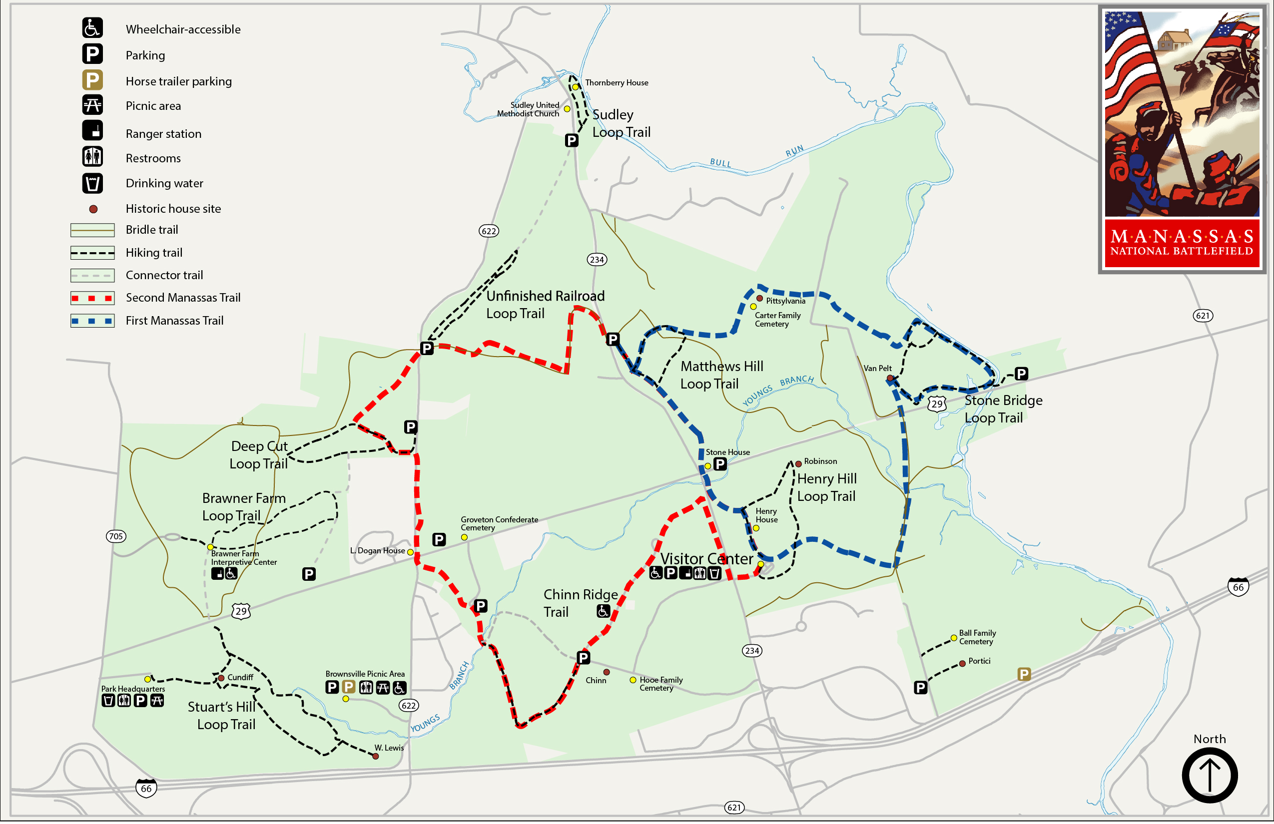
The National Park Service maintains several loop trails through the preserved areas of the battlefield. The trails are of various lengths and signage provides historical context to the many sites encountered along the way. The NPS provides an excellent trifold map, available at the visitor center or on the park’s website, which can help you select the right trail for you based on your interest and level of comfort walking the sometimes hilly terrain. At 5.3 miles, the First Manassas Trail provides the broadest perspective to the battlefield and the events of that momentous July day.
The trail begins at the park’s Henry Hill Visitor Center, which should certainly be the first stop for any new visitor. The well-appointed center houses a small theater, museum and a map with twinkling lights depicting the troop movements around the battlefield. National Park Rangers also offer very informative interpretive lectures daily explaining how these two quickly assembled armies would come to meet on this hallowed ground.
Exiting the visitor center, the trail cuts across adjoining Henry Hill, past a statue of the Confederate General Thomas “Stonewall” Jackson. It was during this battle that Jackson received his famous moniker. As Jackson was preparing for the defense of Henry Hill, another Confederal general, Bernard Bee, likened Jackson to a stonewall and instructed his troops to join with Jackson’s Virginia brigade. A monument to General Bee, who was killed at the battle, stands nearby. The trail continues along Henry Hill and crosses the “Reinforcement Road” a feint trail used by some Southern reinforcing units to reach Henry Hill during the battle.
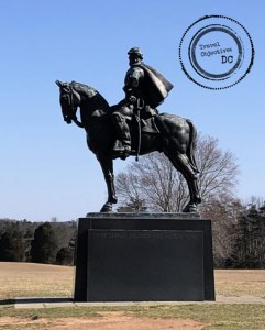
The statue of Thomas “Stonewall” Jackson on Henry Hill dates from 1940.
To boost his forces, the Confederate commander, Pierre Gustave Toutant (PGT) Beauregard worked closely with his counterpart, General Joseph Johnston, who commanded a sizable Confederate force west of the Blue Ridge Mountains in the Shenandoah Valley. To support Beauregard at Manassas, Johnston skillfully moved his forces from Winchester, Virginia to Manassas, using the railroad to quickly cover ground. Johnston set up his headquarters at a plantation to the southeast of the battlefield and allocated his troops for Beauregard to deploy and maneuver during the battle. Their collaboration was instrumental to the rebel victory.

PGT Beauregard commanded Confederate forces at the First Battle of Manassas. General Beauregard was a native of Louisiana, and the Confederate hero of the assault on Fort Sumter.
Photo By Mathew Benjamin Brady – This media is available in the holdings of the National Archives and Records Administration, cataloged under the National Archives Identifier (NAID) 525441., Public Domain, https://commons.wikimedia.org/w/index.php?curid=1197391
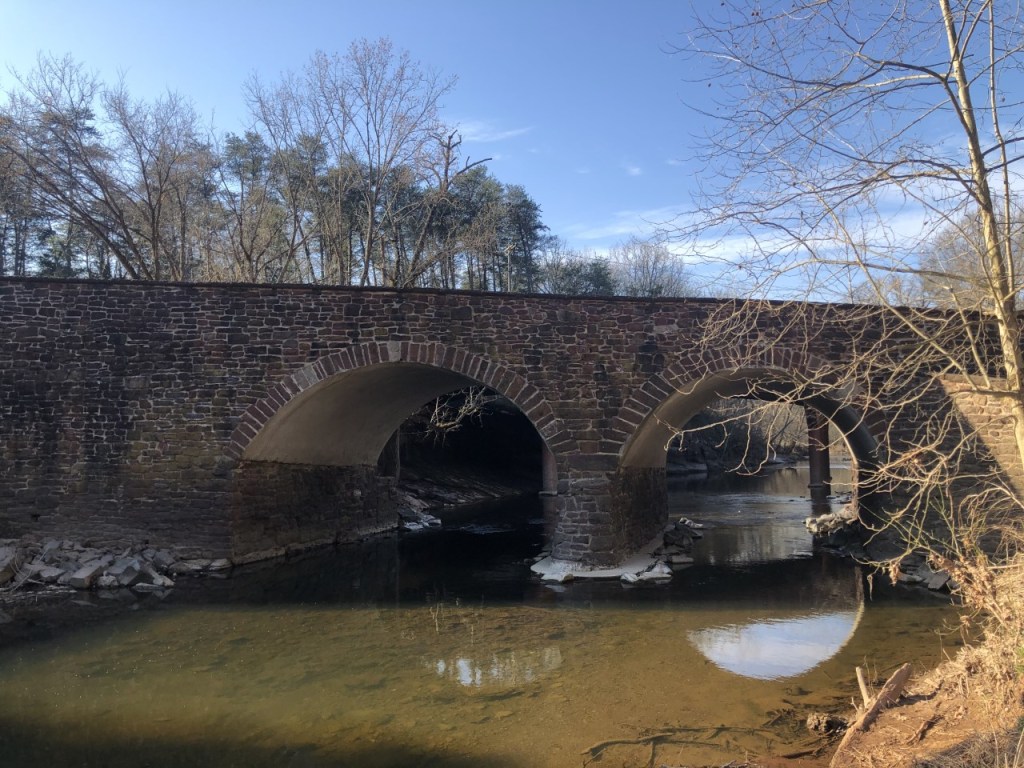
After traversing Henry Hill, the trail then moves through a hardwood forested area and then into an open meadow before crossing a busy road known as the Warrenton Turnpike during the Civil War, but known today as U.S. Route 29. After crossing the highway, follow the trail uphill, pass the ruins of a farm and then turn west, descending along a ridge overlooking the famous Stone Bridge.
The bridge figured prominently into the events on the day of the battle. With rebel forces taking up positions on the western side of the Bull Run to defend the transportation links at Manassas, the Union plan was to outflank Beauregard on the left edge of his line, which was situated on the ridge overlooking the the bridge.
The Union army commander, General Irvin McDowell ordered a diversionary attack commencing at 5:30 that morning on the rebel forces holding the end of the line. Meanwhile his main force would cross the Bull Run further to the northwest.
A Confederate signal station observed these troop movements and warned Confederate Colonel Nathan Evans, who commanded two regiments on the Confederate left. After receiving the warning of the flanking maneuver, Evans ordered most of this troops away from the ridge to Mathews Hill, further west of his position, leaving four companies of South Carolina militia. Evans redeployment of those troops proved essential and would shape the later battle.
After passing the Stone Bridge, the trail runs along a segment of the Bull Run. Although not particularly deep nor wide, the creek’s banks are quite steep, which made access to shallow fords with level banks of importance to both armies.
Leaving the Bull Run, the trail turns west and continues through fields and wooded areas. During the time of the battle, farms and plantations predominated in the area and the land was largely cleared of trees and brush opening up fields of fire and making it easier to observe troop movements. Interpretive signs and weathered stone markers dot this portion of the trail, providing the hiker additional background on troop movements and conditions on the day of the battle.
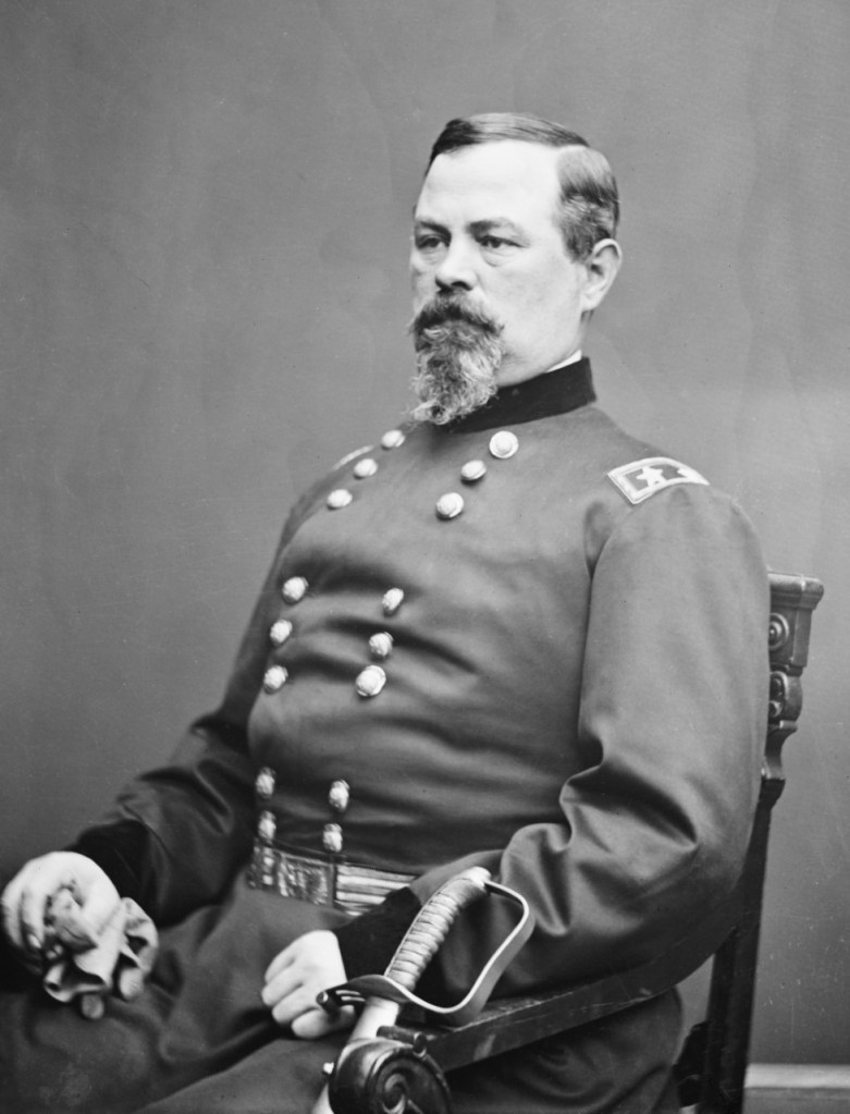
General Irvin McDowell commanded the Union Forces. More experienced in military administration than command, McDowell understood his troops were green, but there was significant political pressure on him to act.
Photo from the Brady National Photographic Art Gallery (Washington, D.C.)
The trail emerges from the woods onto the open terrain of Mathews Hill. From its high ground, scenic vistas looking south and west give an excellent view of major portions of the battlefield. Across the open terrain are clear views of Henry Hill and the visitor center. U.S. Route 29 cuts across and seemingly bisects the landscape.
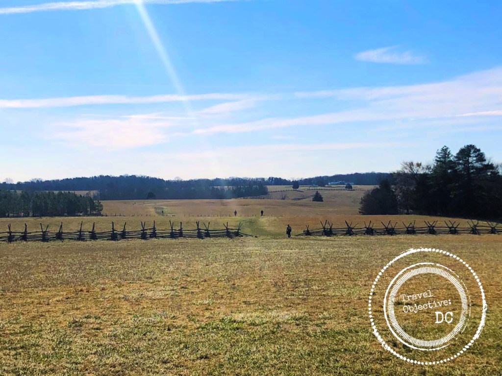
Mathews Hill was the site of significant fighting in the next phase of the battle. Evans’ dispatched troops from the Stone Bridge took up a defensive position on this hill and by 10:30 that morning were encountering the first wave of Federal troops who had crossed the Bull Run further to the north of the Stone Bridge. The rebels fought stubbornly against a strengthening Federal force. Several Confederate regiments arrived to reinforce Evans’ troops. But after several unsuccessful counterattacks and becoming badly outnumbered, the Southerners withdrew from Matthew’s Hill.
Making a critical error that would later cost him the battle, General McDowell did not immediately pursue the rebels as they retreat toward Henry Hill. A delay of over an hour allowed Southerners to organize defensive positions, as their reinforcements continued to arrive from Manassas.
Leaving Matthews Hill, the final mile of the trail begins a slow decent, past the landmark Stone House, across U.S. Route 29 and then up Henry Hill, site of the battle’s fateful culmination. More of a broad plateau than a hill, Henry Hill was named for the Henry Family farm which occupied the area during and for many years after the battle.
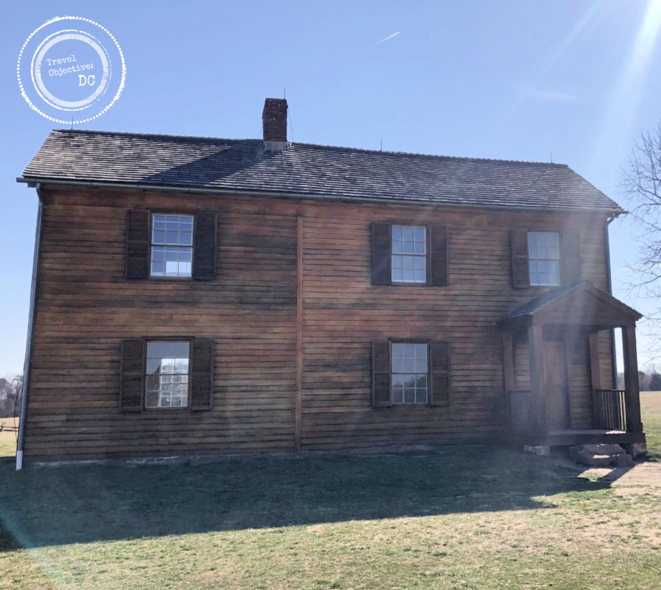
Prominent on Henry Hill is the Henry House. The original house was damaged during the battle and its inhabitant, Mrs. Judith Carter Henry, was killed. The current house was rebuilt after the Civil War by the Henry Family.
The ensuing artillery fight turned into an infantry battle as Union and Confederate regiments arrived, attacking and counterattacking in the vicinity of the cannons. Buoyed by fresh troops which continued to stream in from Manassas and with numbers now on their side, the Southerners would take the upper hand forcing McDowell’s army to retreat around 4:00 pm and begin a long and sometimes chaotic march back towards Washington.
After the battle, the casualty counts conveyed the bloodiest day in American history, up to that time. The Federal Army suffered the loss of 460 soldiers and over 1,000 wounded and another 1,300 captured or missing. Southern losses were less, but still alarming with 387 killed and about 1600 wounded.
Both sides began to understand victory in this war would be neither easy nor quick. Many more battles would follow. Indeed, in a little more than a year, the armies would once again return to these fields to fight an even bloodier battle.

Route Recon
Manassas National Battlefield Park is located about 25 miles west of Washington, DC.
If you are using a GPS device, the mailing address of the Henry Hill Visitor Center is:
6511 Sudley Road, Manassas Virginia 20109
From Washington D.C. and Points East: Travel west on Interstate 66 to Exit 47B, Route 234 North, Sudley Road. Proceed through the first traffic light. The entrance to the Henry Hill Visitors Center is on the right, just past the Northern Virginia Community College.
From Points North: Travel south on I-95 to the Capital Beltway, Interstate 495. Travel west towards Silver Springs, Maryland. Continue on the Beltway for approximately 10 miles, crossing the Potomac river into Virginia. Take the exit for Interstate 66 west to Manassas. Take Exit 47B, Route 234 North, Sudley Road. Proceed through the first traffic light. The entrance to the Henry Hill Visitors Center is on the right, just past the Northern Virginia Community College.
From Points South: Travel north on Interstate 95 to Exit 152, Route 234. Turn left at the traffic light on to Route 234 North, Sudley Road. Stay on Business Route 234 (do not take the by-pass) and travel for approximately 20 miles just beyond the city of Manassas. The entrance to the Henry Hill Visitors Center is located on the right, just past the entrance to the Northern Virginia Community College.
From Points West: Travel east on Interstate 66 to Exit 47, Route 234 North (Sudley Road). Turn left on Route 234 and proceed through the first traffic light. The entrance to the Henry Hill Visitors Center is on the right, just past the Northern Virginia Community College.
Unfortunately, there is no public transportation to the park.
Safety Briefing
Be aware of the following before you start your hike:
The trail can be moderately strenuous and muddy in a few portions, so proper footwear is important.
Many trails, both official and unofficial, intersect the main hiking trails, so it is important to use either an electronic or paper map and be mindful of your location. Follow trail blazes appropriate for your trail, blue blazes indicate a hiking trail and yellow blazes indicate horse trails.
Bring plenty of water.
Beware of ticks! Stick to the trail. Insect repellent is recommended.
In the event of an emergency on the trail, call 911 from your mobile phone.
Should you see an object of potential historic significance, please leave it in place and notify the park staff at 703-361-1339 x0.
Pets are permitted on all park trails but must be kept on a leash no longer than 6 feet.
