Remembering President James Garfield


Today, few Americans could tell you very much about James Abram Garfield, our 20th President. A few people with an interest in history might recall that Garfield was assassinated early in his presidency by a “disgrunted office seeker”. Professional historians generally rank his shortened presidency as “below average” or do not rank him at all. 

This is rather regrettable as Garfield was a courageous and dedicated leader who died for fighting what he believed in. Fortunately, he has one distinction the vast majority of presidents will never have: his own memorial on the US Capitol grounds. 

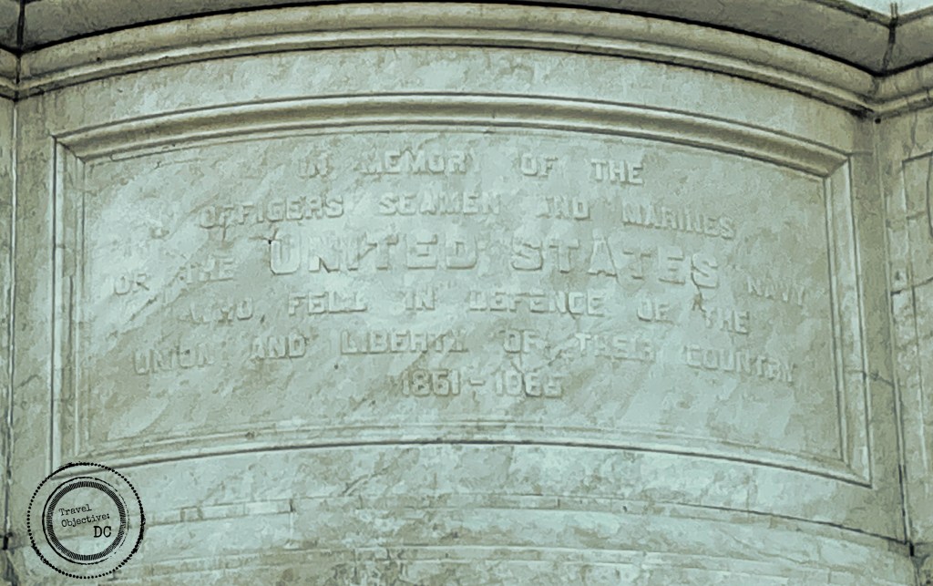
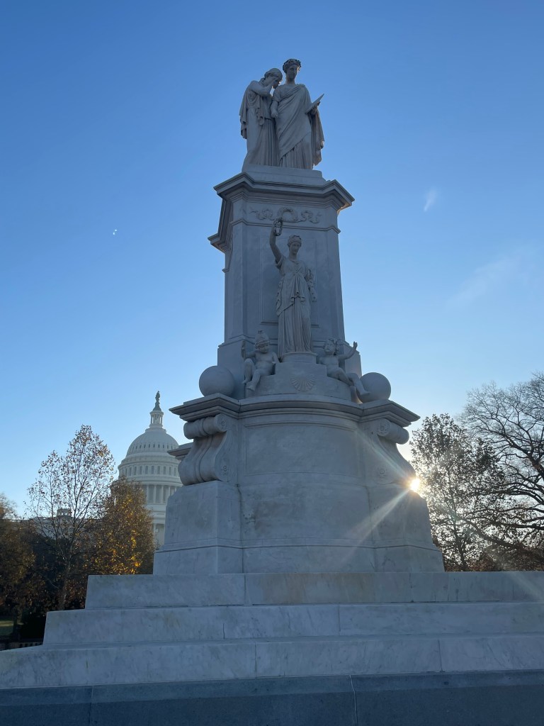
One of three monuments on the west side of the Capitol building adjoining the National Mall–along with the Ulysses S. Grant Memorial and the Peace Monument–Garfield’s monument is located within a traffic circle at the intersection of First Street SW and Maryland Avenue near the US Botanic Garden.

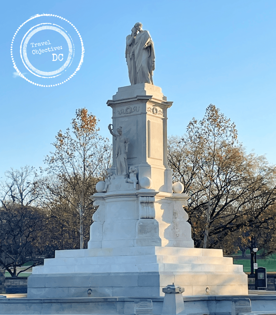
The Garfield Memorial on the west grounds of the US Capitol

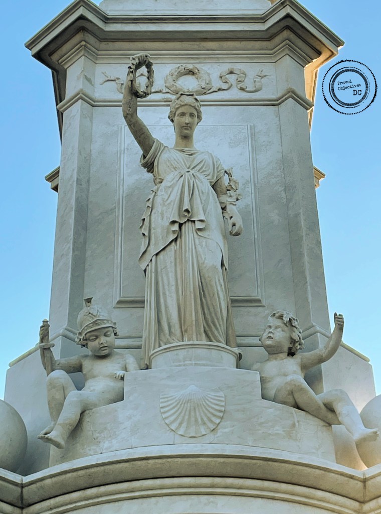
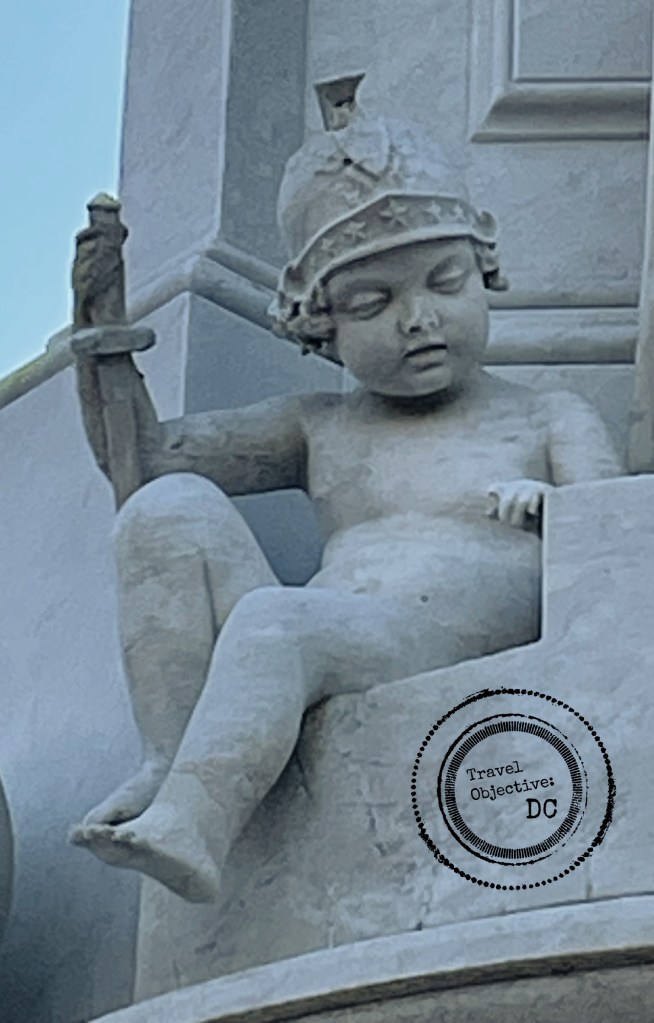
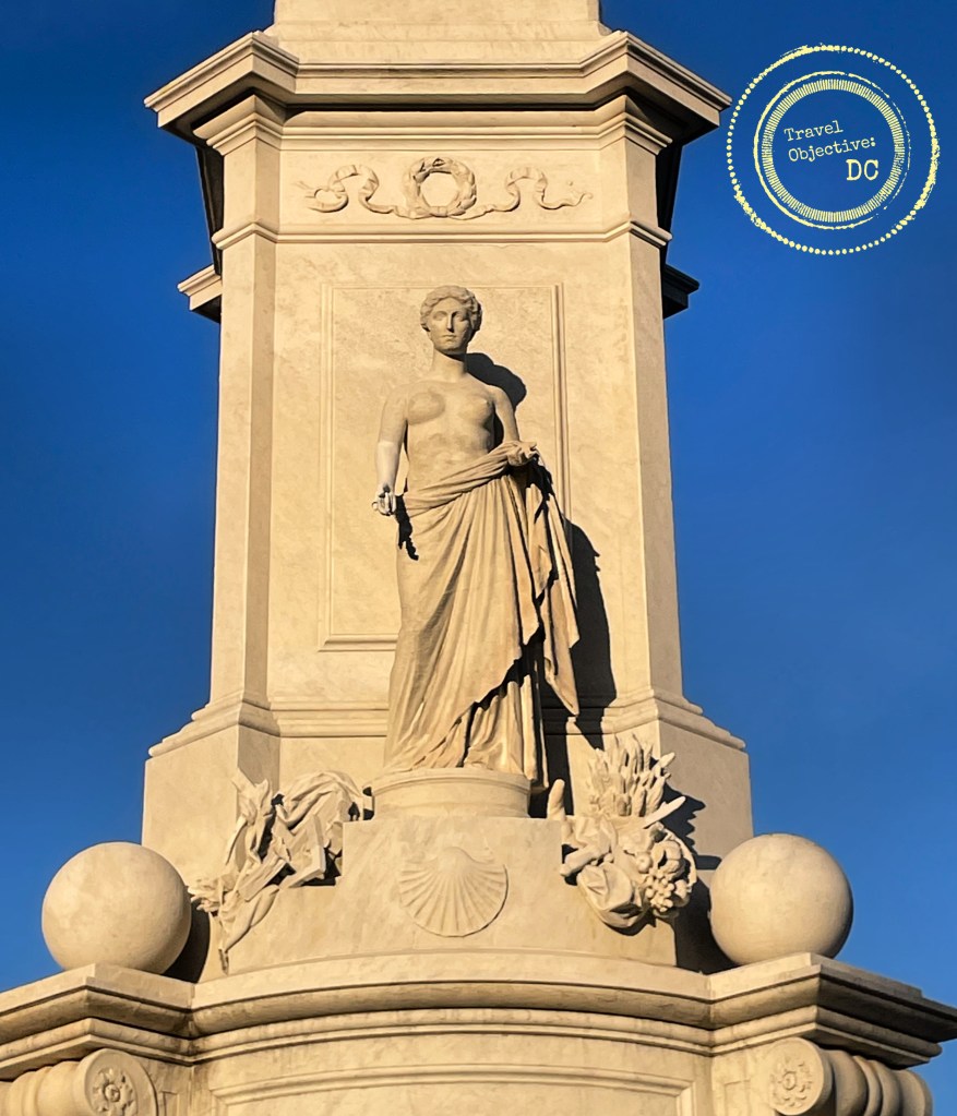
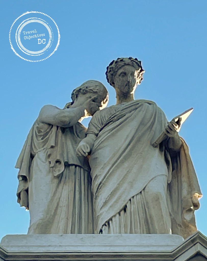
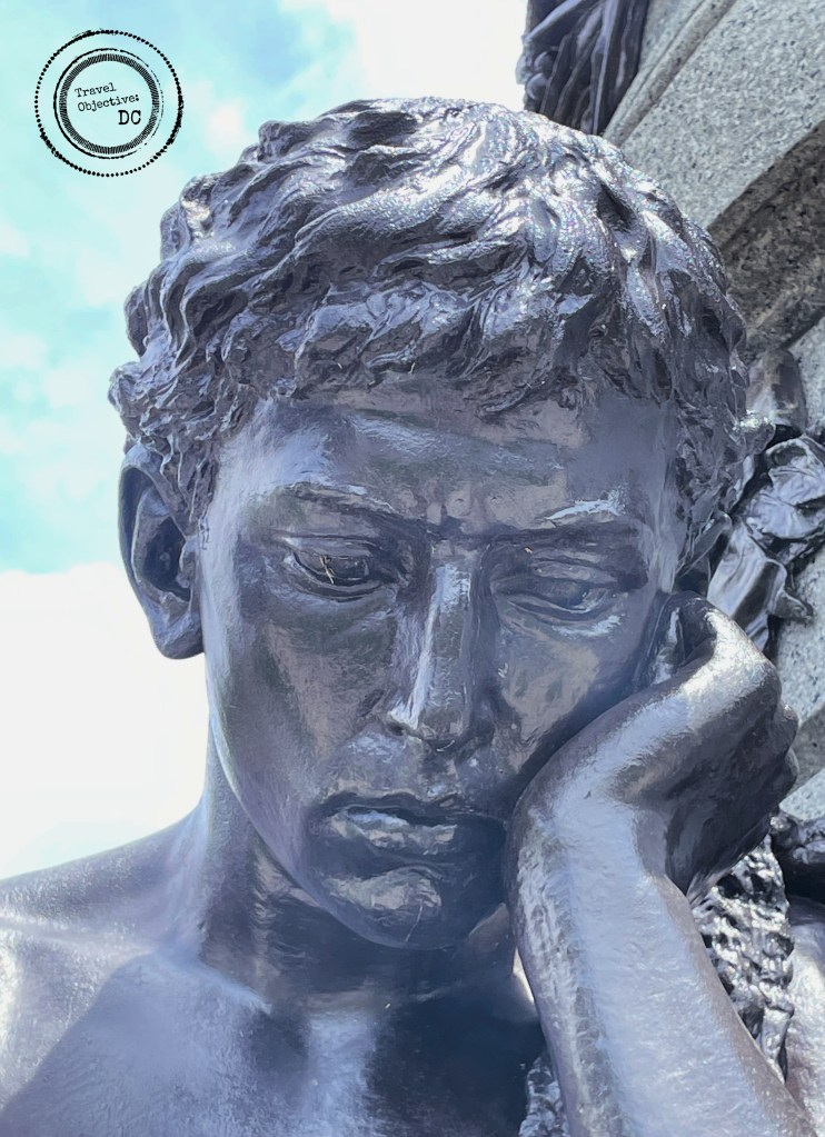
John Quincy Adams Ward, a prominent 19th century sculptor and friend of Garfield designed the monument. Ward depicted Garfield in bronze atop a round, tapered granite pedestal. He is shown giving a speech, grasping a scroll in his left hand and gazing intently at his audience. His foot is placed slightly off the platform and meant to symbolize Garfield as a man of action. At the base of the pedestal are three classical Roman figures representing the key phases of Garfield’s life as a young scholar, military leader and statesman.

Garfield personified the American success story, so much so that renowned author Horatio Alger wrote his biography. Alger published From Canal Boy to President in 1881.  

James Garfield was born in 1831 in a log cabin in northeastern Ohio. His family was poor and his father died when Garfield was a young man. He went to work to support his family, taking a variety of jobs including helping tow canal boats. While recovering from a serious bout of malaria contracted on the canal, Garfield’s mother convinced him to return to school. Garfield was an excellent student with a strong work ethic. He took to his studies and worked his way through the Western Reserve Eclectic Institute as a janitor and school teacher.  After graduation, he became a preacher. Garfield then studied law at Williams College in Williamstown, MA. 

The face of the young scholar figure on the Garfield Monument

Between his jobs as a preacher, teacher and lawyer, Garfield became a skilled orator. He entered politics and was elected to the Ohio State Senate as a Republican in 1860. As the Civil War broke out, Garfield was an abolitionist dedicated to the Union’s cause. He led fundraising and recruitment efforts for Ohio volunteer regiments. 

Eager to enter the Army, Garfield began studying military tactics.

Garfield commanded a Union Army brigade at the Battle of Middle Creek near Prestonsburg, KY in January 1862. Under his steady leadership, Garfield’s troops routed the rebel forces who retreated into Virginia. Although not considered a major battle today, the victory was an important boost to Union morale and brought Garfield widespread recognition. 

After the battle, Garfield was promoted to brigadier general. He was later assigned as Chief of Staff to General William Rosencrans of the Army of the Cumberland. After the decisive Union loss at the Battle of Chickamauga, Ulysses S. Grant relieved Rosencrans of command. Rather than Garfield, Grant appointed George H. Thomas to succeed Rosencrans. Although Garfield was later promoted to Major General, being passed over for the army command led him to consider a return to politics.

Photograph of James Garfield as Brigadier General

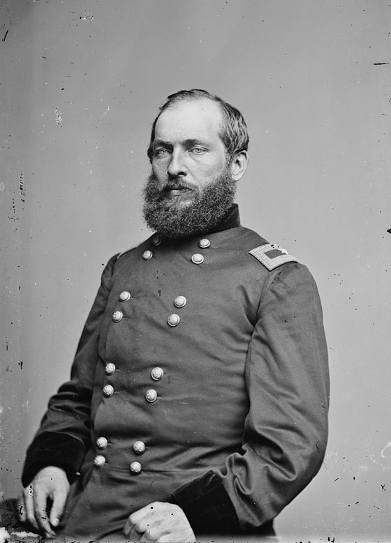
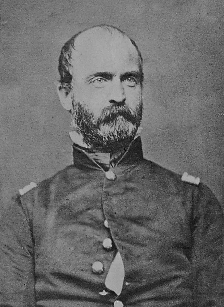
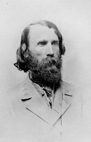
Brigadier General James Garfield, circa 1862

-Retrieved from the Library of Congress

In 1862, Garfield won an election for a seat in the House of Representatives. Garfield would serve nine terms in the House representing his home state of Ohio. While in Congress, Garfield was known for supporting civil rights for African Americans, the gold standard for the US dollar, and improving education for all. He helped establish the Federal Bureau of Education in 1870 to study and enhance educational methods across the country.

Garfield excelled as a Congressman, chairing powerful committees and mastering the nuanced details of legislation, especially on financial matters. At the same time, he was affable, a good conversationalist and considered one of the nicest men in Washington. 

At the deadlocked Republican presidential convention in 1880, Garfield was nominated on the 36th ballot. He defeated his fellow veteran Winfield Scott Hancock in the general election and was sworn in as the 20th President of the United States on March 4, 1881.  (He is the only president to be elected while a serving member of the House).

Republican Campaign Poster from the 1880 Presidential Election

During his presidency, Garfield fought one very significant battle.

His victory in that battle still impacts us today.

It had long been the practice in America that Federal employees were selected based on their demonstrated loyalty to political parties. Senators and representatives from a newly elected president’s party would act as “patrons” and recommend party workers, relatives and financial backers to the administration for government jobs.  

In the 1870’s, the issue of patronage was splitting the Republican party. Many wanted to maintain patronage while others wanted reform. Garfield opposed the patronage system and was a proponent of a professional, apolitical civil service. He knew it would make the Federal government much more efficient, limit corruption, and relieve elected officials from constant demands for jobs.

Garfield staged a showdown with New York’s two powerful Republican senators who were both savvy practitioners of the patronage system. Garfield nominated his own candidate for the important position of customs collector in the Port of New York. The two New York senators resigned in protest fully expecting to be quickly returned to office by the New York legislature. However, during their absence from Washington, Garfield pushed his nomination through the US Senate, embarrassing the two senators.

Sadly, this important victory over patronage directly contributed to Garfield’s death.

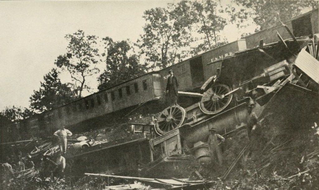
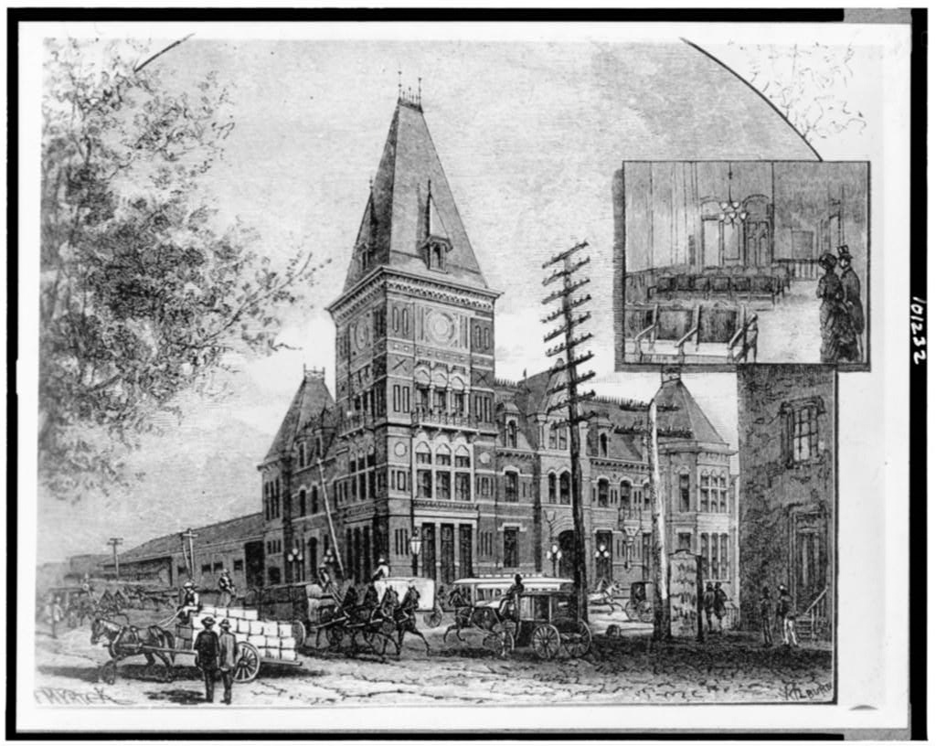
On July 2, 1881, Garfield was preparing to board a train at Washington’s Baltimore and Potomac Railroad Station. Suddenly, two shots rang out, striking Garfield in the arm and back.  Garfield’s assailant was Charles Guiteau, who may forever be known in history books as the “disgruntled office seeker”.  

The old Baltimore and Potomac Railroad Station. The station was demolished in 1907 after Union Station was opened. The station was located where the West Building of the National Gallery of Art stands today. [Undated photo]

-Retrieved from the Library of Congress

Photograph of the old Baltimore and Potomac Railroad Station in Washington, DC

Guiteau had written, delivered and published a speech supporting Garfield in the election. He thought this entitled him to a consular job at the US Embassy in Paris. While Guiteau had no dislike for Garfield as a person, he believed he would help preserve the patronage system by killing the president. Guiteau was quickly apprehended in the train station. He was later found guilty of murder and executed about 18 months after the shooting. 

The cover of Puck, a 19th century satirical magazine from July 13, 1881 with an image of Garfield's assassin Charles Guiteau

The cover of Puck, a 19th century satirical magazine from July 13, 1881 with an image of Garfield’s assassin Charles Guiteau holding an extortion note.

Garfield would linger on for the next two months. On September 19, 1881, he died from sepsis poisoning, just five and an half months into his presidency.

In the wake of Garfield’s death, Congress passed the Pendleton Act, which established a merit-based system for hiring and promoting Federal employees. The Pendleton Act was signed into law by the new president, Chester A. Arthur, who previously had been a supporter of the patronage system. As a surprise to many, Arthur quickly set about implementing its provisions to reform the civil service. 

The country closely followed Garfield’s deterioration and he was widely mourned after his death. Work then quickly began on building him a suitable memorial. The Society of the Army of the Cumberland, a Union veterans’ organization, formed a fundraising committee and ultimately raised over $28,000. They also successfully lobbied Congress for additional funds for the statue and the pedestal.

The newly unveiled Garfield Memorial was prominently placed on the cover of Harper’s Weekly on May 14, 1887.

The cover of Harper's Weekly from May 14, 1887.

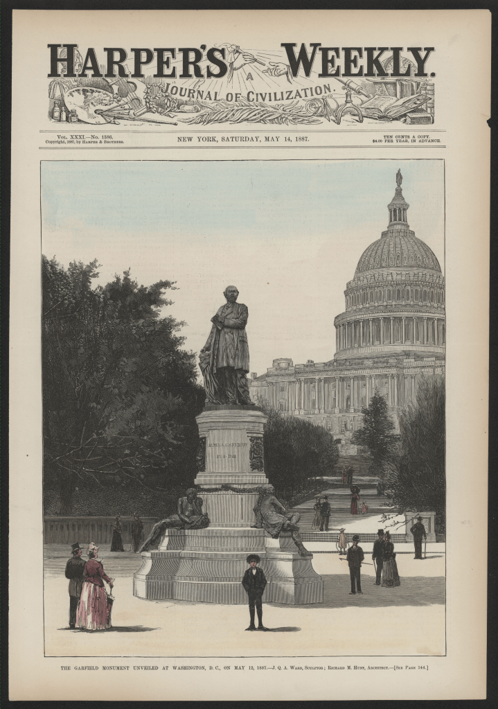
The memorial was dedicated on May 12, 1887, in a grand ceremony attended by President Grover Cleveland, many senior government officials, military leaders and veterans from the Society of the Army of the Cumberland and the Grand Army of the Republic. Cannon salutes were fired and the US Marine Corps Band played stirring patriotic music.

Today, the Garfield Memorial remains a prominent and visible reminder of the talented, resourceful and considerate man who was our 20th president. 

* * *

Route Recon

The Garfield Memorial is located within a traffic circle at the intersection of First Street SW and Maryland Avenue near the US Botanic Garden.

There is limited street parking nearby near the Botanic Garden.

The closest Metro Station is at L’Enfant Plaza. Exit the station through Entrance A for 7th Street and Maryland Avenue. Follow Maryland Avenue to the northwest, pass the Dwight D. Eisenhower Memorial and the US Botanic Garden.

Logan’s Legacy

The heavily mustachioed bronze visage of Major General John Alexander Logan gazes down upon his namesake park and traffic circle in Northwest Washington, DC.

Logan Circle sits at the confluence of four busy thoroughfares. Enclosed within the circle is a popular and well-tended 1.8 acre park with ample benches shaded by oak trees and dotted by interpretive signage. 

These landmarks ensure Logan’s name is familiar to many Washington-area residents. Unfortunately, few may know his story, which is replete with service to our country. 

Photograph of John A. Logan, circa 1880.

John Alexander Logan, circa 1880

-Dewitt C. Pratt, Photographer; Photo Courtesy of the Library of Congress

During the Civil War, Logan was considered a “political general”. He began his political career as a Democrat in the Illinois legislature, aligning himself closely with the state’s leading political figure at the time, Stephen Douglas. Representing a district in southern Illinois, he strongly supported the enactment and enforcement of fugitive slave laws.

In 1858, he was elected to the US House of Representatives. After the firing on Fort Sumter and the succession of several Southern states, however, Logan used his tremendous oratorical skills both in Congress and in communities across his home region to promote the importance of a strong Union.

In June of 1861, while still a member of Congress, Logan attached himself as a civilian volunteer with a Michigan regiment and saw combat at the First Battle of Bull Run. In the aftermath of the battle, he eluded rebel fire while retrieving and caring for the wounded. Now determined to fight for a Union victory, he returned to his district in Illinois, raised a volunteer regiment and was appointed its colonel. 

John Logan's equistrian statue in Logan Circle Park in Washington, DC.
Statue of John A. Logan in Logan Circle Park

Unlike many of his contemporary politicans who donned military uniforms, Logan distinguished himself on the battlefield as a troop commander and tactical leader. He led his troops to victories in multiple battles, including Fort Donelson, Vicksburg, and Atlanta, and was seriously wounded on several occasions. He rose to the rank of Major General of Volunteers and briefly commanded the Union Army of the Tennessee. 

Logan inspired tremendous loyalty and dedication in his soldiers. His colleague General Mortimer Leggett said of Logan: He … seemed to have the power to call out of the men every particle of fight that was in them.

After the war, Logan returned to Congress. Switching parties, he was elected to three more terms in the House of Representatives and three terms in the Senate, representing Illinois as a Republican. His views on race seemed to switch as well. During this period, he was a strident advocate for African American rights and urged passage of the 14th and 15th Amendments. 

Bas-relief sculpture of John Logan’s swearing in as a United States Senator from his statue in Logan Circle Park

Bas-relief sculpture of John Logan's swearing in as a United States Senator from his statue in Logan Circle Park

He was also an early supporter of women’s suffrage, backed public education for all, and worked tirelessly to secure greater pensions and other benefits for veterans. 

Logan was considered by many Republicans as a potential presidential candidate. In 1884, he unsuccessfully ran for Vice President on the Republican ticket headed by James G. Blaine of Maine, losing to Grover Cleveland and Thomas Hendricks. 

His veterans advocacy led to his selection as the National Commander of the Grand Army of the Republic (GAR), the powerful Union veterans’ organization. It is here that Logan left his best known mark on American culture. In 1868, Logan directed GAR posts nationwide to decorate the graves of Union war veterans on May 30 when an abudance of flowers would be in bloom. 

Bas-relief sculpture of John Logan conferring with fellow officers from his statue in Logan Circle Park

Bas-relief sculpture of John Logan conferring with fellow officers from his statue in Logan Circle Park

While decorating the graves of Civil War soliders was already occurring in both the North and the South, Logan’s order to the GAR expanded the practice nationwide and set a definitive date for its observance. 

In his order, Logan stressed the importance of veterans adopting and continuing this practice as he wrote: If other eyes grow dull and other hands slack, and other hearts cold in the solemn trust, ours shall keep it well as long as the light and warmth of life remains in us. 

GAR Posts readily adopted the order and organized community observances, which continued to grow in size and scope. In 1938, Congress designated Decoration Day as a national holiday on May 30.  After World War II, the term Memorial slowly replaced Decoration in the name for the day. In 1967, Congress officially changed the name of the holiday to Memorial Day. Four years later, Congress adjusted the date of Memorial Day to the last Monday in May. 

Bas-relief sculpture of Peace from John Logan’s statue in Logan Circle Park

Bas-relief sculpture of Peace from John Logan's statue in Logan Circle Park

After Logan’s death in 1886, the Society of the Army of the Tennessee led the effort to commemorate his service to the country as both soldier and statesman. Sculptor Franklin Simmons, who designed the Peace Memorial, was selected to craft a bronze equestrian statue. Logan’s figure appears atop the 25-foot-high bronze statue with bronze bas-relief panels on each side. Facing north and south are figures representing War and Peace, respectively. 

Along the eastern and western sides of the base are events from Logan’s life. Facing east is a portrayal of Logan conferring with fellow officers, while Logan’s swearing in as a US senator looks toward the west. Initially, these two images caused a minor uproar as the public realized they were factually inaccurate until Logan’s widow, Mary, explained these depictions were intended to be more illustrative rather than representing distinct historical events.   

The statue was dedicated in a grand ceremony led by President William McKinley in 1901. A large circular park known as Iowa Circle was selected as the location of the statue as Logan and his family had lived nearby. The area was emerging in the 1880’s as a fashionable middle-class neighborhood. Congress officially changed the name to Logan Circle in 1930.  While the late 20th century was a difficult time for the neighborhood, today Logan Circle is known as a trendy, gentrified area with popular restaurants, theaters and many rehabilitated historic properties. 

John Logan's post-war home at 4 Logan Circle NW in Washington, DC

John Logan’s post-war home at 4 Logan Circle NW in Washington, DC

Washington, DC is not alone in naming landmarks after John Logan. Across the country, there are counties, schools, plazas, a junior college, a former military post and even a national cemetery all named for John Logan.

While he might be best remembered for his contribution to creating Memorial Day, his real legacy is one of leadership and service to our country.  Whether on the battlefield, in the halls of Congress, or across Illinois, John Logan was a dedicated public servent who fought hard for a stronger country and better society. 

Route Recon

Logan Circle is located at the intersection of 13th Street, P Street, Rhode Island Avenue and Vermont Avenue in Northwest Washington.

The nearest Metro Station is Mount Vernon Square/Convention Center on the Green and Yellow Lines. It is a 15-minute walk from the station to Logan Circle.

There is street parking in the area.

Lost and Found History at the Missing Soldiers Office


Along 7th Street in Northwest Washington, a narrow staircase takes the visitor up two flights to a suite of simple rooms restored to resemble their 19th Century appearance.

Today these rooms are often quiet, save for the tours and visitors. But from 1865 through 1868, they bustled with an extraordinary initiative led by Clara Barton. The noted humanitarian undertook the challenging but critically important mission of identifying missing Union solders from the Civil War. 

By 1865, the former teacher and Patent Office clerk had already made a name for herself. She spent the Civil War years gathering and distributing medical supplies, food and other items for the Union Army. At the same time, she assisted soldiers, nursing the sick and wounded, and comforting all those she could. 

A famous photo of Clara Barton taken my Mathew Brady.

A photograph of Clara Barton by Mathew Brady

-Library of Congress

After the war, she became aware of the large volumes of mail arriving at Army facilities either addressed to missing soldiers or seeking information on their whereabouts. Sadly, most of these letters went unanswered. At the time, the Army had no system for notifying a family upon the death or absence of a soldier.

After receiving the endorsement of President Lincoln, Barton undertook the work of identifying as many of the Union Army missing as possible. She established the Office of Correspondence with Friends of the Missing Men of the United States Army, which would later become known more simply as the Missing Soldiers Office. 

Barton based the operation on the third floor of a building then located at 488 1/2 7th Street Northwest. Originally built in the 1850’s, the three story brick building was of a typical design for Washington, DC. The first floor was dedicated to retail space along busy 7th Street. The second floor usually provided office space to local professionals while boarders rented rooms on the third floor. 

The staircase to the 3rd Floor at the Clara Barton Missing Soldiers Office Museum

The staircase to the 3rd Floor at the Clara Barton Missing Soldiers Office Museum

Barton first rented a third floor room to lodge in and store some medical supplies in June of 1861.  However, the Missing Soldiers Office would require more space. She rented additional rooms from her friend and landlord Edward Shaw, a co-worker from the Patent Office.

Today there are nine rooms on display as part of the Clara Barton Missing Soldiers Office Museum. The dimly lit rooms have pretty wallpaper, but are largely empty. Creaks emanating from the uneven hardwood floors add a sense of authenticity to the space. Each room has some period furnishings and a few artifacts on display.

Much of the work of the Missing Soldier’s Office was performed in a large room facing 7th Street. Originally three rooms, Barton and Shaw continued to expand the office my removing walls to accommodate the growing staff and workload. The room’s location made it a natural choice to be the principal working area as the westward facing windows fill the room with natural light, in contrast to the other dimly lit areas. An artist’s depiction shows what the room may have looked like with racks for storage of supplies and large tables for reading and responding to correspondence.

The original door to Room 9 of the Missing Soldiers Office. Note the mail slot on the lower left, cut into the door by Clara Barton.

Barton implemented a straight forward and highly effective system for gathering information about the missing. After she received letters regarding the whereabouts of a missing soldier, a file was created. The names of the missing, organized by state of origin, were compiled into large lists called a Roll of Missing Men.

These rolls were printed on large broadsheet paper and distributed nationwide. They were hung prominently in post offices, government buildings and other public gathering places. The names were also published in newspapers. Returning soldiers or anyone with any information about a name on the list was invited to write the Missing Soldiers Office. Incoming letters were analyzed and collated into the files in the hopes of ultimately identifying the soldier’s fate. 

An example of a Roll of Missing Men which Clara Barton had printed and distributed nationwide.

A Roll of Missing Men. Clara Barton had these large lists printed and distributed nationwide.

-Photo courtesy of the Clara Barton Missing Soldiers Office Museum

Barton and her staff collected and scrutinized any available records from prisons, hospitals, and burial sites. Former prisoners of war were also interviewed and proved to be excellent sources of information.

Barton had some early success in her work when she met a young solider named Dorence Atwater. Atwater had been a prisoner at the notorious Andersonville prison camp in southern Georgia where he kept the camp records on the burials of deceased Union prisoners. He also secretly kept a second list of burial information, which he smuggled out of the prison at war’s end. 

Atwater and Barton accompanied an Army visit to Andersonville in the summer of 1865. Using Atwater’s list and other records, troops replaced temporary, numbered grave markers with more permanent headboards listing the solders names and units. While this work was underway, Barton and Atwater responded to letters with the updated burial information. Ultimately, Barton and Atwater were able to identify the graves of all but 450 of the 13,000 Union soldiers who had died at Andersonville.

A photo of Dorence Atwater.

A photograph of Dorence Atwater taken around 1870

-Connecticut State Library

One of the other rooms on the third floor served as Clara Barton’s bedroom, another as Shaw’s. Barton also decorated one room as a parlor where she would receive visitors. Receiving and responding to correspondence was only a portion of her role in the Missing Soldiers Office. Barton financed most of the operation herself, so she was often busy talking to donors and lobbying Congressmen. Of course, family members, those offering information, Army officials and others with an interest in her work would regularly call upon her on the 3rd floor.

As Barton wrote in her diary “…I was to leave everything else and fit up my little parlor with its cabinet of relics…I must see people if I would get their interest and I must have a suitable place to see them in…”

Barton closed the Missing Soldiers Office in late 1868. Incoming correspondence had slowed and she was suffering from exhaustion. But the results of the years long effort were most impressive. The Missing Soldier’s office received over 63,000 letters of inquiry and responded to over 42,000. It distributed over 99,000 Rolls of Missing Men and helped to identify over 22,000 soldiers.

Additionally, when Barton and her staff could positively identify a missing soldier, their letter to the family was official government correspondence. It could be used as supporting documentation for a death benefit application. As such, these letters could provide a route to material support as well as emotional consolation.  

After closing the office, Barton traveled to Europe on her doctor’s advice. She visited a friend’s family in Geneva, Switzerland. While there, Barton was first exposed to the Geneva Convention and the work of the International Committee of the Red Cross. The next chapter of her life was waiting, and she did not look back.  

Photograph of Boyce and Lewis Shoe Store at 437 7th Street. The facade hides the original brick exterior and several windows on the 2nd and 3rd floors.

-Library of Congress

In Washington, Shaw closed the previous chapter of her life. After she left for Europe, he packed up some of her personal belongings along with a mix of other materials from the third floor and placed them in the attic. He would live on the third floor a few more years, before moving on. Other boarders would come and go. In 1913, the third floor was sealed off from the rest of the building. The Missing Soldier’s Office became a bit of a footnote, a brief interlude in Barton’s life. 

Just before Thanksgiving in 1996, a General Services Administration carpenter named Richard Lyons was inspecting the building before its scheduled demolition. While examining the unused 3rd floor, he discovered the trove of artifacts stored 120 years earlier, including the now iconic Missing Soldiers Office sign.

The iconic Missing Soldiers Office sign which identified the office location in Room 9 on the 3rd floor and its manager, Miss Clara Barton.

When a GSA carpenter discovered the Missing Soldiers Office sign in the attic, he knew he had found something significant.

Lyons began a research project that ultimately saved the building and an extensive renovation followed. The space is currently administered by the National Museum of Civil War Medicine, which partnered with the GSA in the renovation space. The Clara Barton Missing Soldiers Office Museum was opened to the public in 2015.

Today, a visit to the museum feels like a step back in time. The first floor, which for decades was used as a shoe store, is an open reception area housing the gift shop along with a large mural depicting the life of Clara Barton. 

Reproduction wallpaper hangs in a room at the Clara Barton Missing Soldiers Museum. Curators conducted extensive research on the original wallpaper samples still available to recreate the look of the rooms in Barton’s time.

Reproduction floral wallpaper hanging on one of the rooms at the Clara Barton Missing Soldiers Office

Extensive research has been done on returning the rooms to their 19th Century appearance, especially the wallpaper. Barton favored bold floral patterns for her personal space, office spaces had more muted colors in geometric designs. 

A selection of artifacts is on display through the rooms, including receipts, pens, stationery packaging, old clothing, and most impressive, a copy of the first Roll of Missing Men.

Today, of course, Barton’s work would not be necessary. The US Military has a very organized system for notifying next of kin about the loss of a service member. DNA samples are taken and stored to aid in identification. The Defense POW/MIA Accounting Agency works to identify the missing from earlier wars and conflicts. 

But before these systems were in place, it was a visionary Clara Barton who saw the need and created a structure to meet it. To make it work, she raised money, traveled the country giving speeches, lobbied Congress, issued reports, sought assistance from other Federal agencies and directed an extensive program of correspondence and outreach. 

It all happened over 150 years ago on 7th Street. Climb the stairs and see for yourself. 

The entrance door leading to the stairway at the Clara Barton Missing Soldiers Office Museum.

* * *

Route Recon

The Clara Barton Missing Soldiers Office Musuem is located at 437 7th Street NW, Washington, DC 20004. The museum is open on Fridays and Saturdays from 11:00 AM to 5:00PM. The nearest Washington Metro Station is Archives-Navy Memorial-Penn Quarter. From the station exit, make a U-Turn back toward 7th Street. Turn left on 7th Street and proceed past D Street. The Clara Barton Missing Soldiers Office Musuem will be on your right just before E Street.

Command Reading

Relics of War, the History of a Photograph by Jennifer Raab

In 1865, on her visit to Andersonville, Clara Barton collected a variety of small artifacts she found around the camp, such as dug out bowls and cups, woven reed plates and spoons made from animal horns. She arranged these pictures on a writing desk and had them photographed. Barton used the relics in her work to raise awarness and enthusiasm for her Missing Soldiers Office and its mission. In her book, Dr. Raab, a professor of the history of art at Yale University, uses artistic criticism techniques to interpret the photograph and what it came to mean for post Civil War American society.

Hancock, the Superb


Statues of military leaders on horseback are a common site in plazas and squares around Washington, DC. While the statues might seem ordinary, the men featured on them are usually not. This is certainly the case with the statue of General Winfield Scott Hancock in the Penn Quarter neighborhood near the Navy Memorial.

It is hard to imagine a military career today as the one experienced by this 19th century Army leader.

As the Union Army was quickly expanding to meet the grim realities of the Civil War, Major General George McClellan, Commander of the Army of the Potomac, promoted his long-time acquaintance Hancock from captain to brigadier general and assigned him to brigade command. 

Hancock would go onto distinguish himself during the war, earning the nickname “Hancock the Superb”. He ultimately served 42 years on active duty and 25 years as a general officer. 

The equestrian statue of Winfield Scott Hancock.
The statue of General Winfield Scott Hancock

In 1896, the equestrian statue was dedicated to Hancock portraying the famous general in his more senior years. But the simple monument does not tell the full story of this highly respected Union Army general.

Hancock hailed from Montgomeryville, Pennsylvania. He was the son of a lawyer in a locally prominent Democratic family. His parents named him after Winfield Scott, the Army’s most senior officer at the time. His name was apt. From an early age, the young Winfield demonstrated a keen interest in military affairs. He could often be found leading young boys in a “youth militia company” on marches through town.

At the age of 16, he was accepted at West Point, graduating in 1844.

Assignments followed in the west and in Mexico during the Mexican-American War. After the war, Hancock often received Quartermaster assignments which taught him important lessons in logistics, organization and how to navigate the Army’s bureaucracy. His affable nature, technical proficiency and dashing good looks earned him an excellent reputation among his soldiers, colleagues and superiors.

Photograph of Winfield Scott Hancock.

A photograph of General Winfield Scott Hancock taken sometime between 1861-1865 by Brady’s National Photographic Portrait Galleries

-Library of Congress

Militarily, Hancock is probably best remembered for his actions as a corps commander in the Union Army of the Potomac at the Battle of Gettysburg in 1863. In the prelude to the fighting, Hancock arranged Union troops in a broad defensive position along high ground south of the town. Once the fighting began in earnest, Hancock led from the front, quickly maneuvering his troops to reinforce positions along the Union line. On the third day of the battle, Hancock was severely wounded in the thigh during Confederate General George Pickett’s famous charge against the Union center. 

Hancock would not leave the field until rebel troops had been repulsed. He would take five months to convalesce and would never completely heal from the wound. 

Early in his career, Hancock became very good friends with a North Carolina-born officer named Lewis Armistead. However, in 1861, while both were stationed in California, they said their good-byes and headed east, destined to fight on different sides. The two faced each other on the final day of Gettysburg when Armistead led a brigade as part of Pickett’s Charge against troops commanded by Hancock. Armistead was fatally wounded during the battle and died two days later. 

A photograph of Lewis Armistead, taken between 1861 and 1865, by an unknown photographer.

Photograph of Lewis Armistead

Both Hancock and Armistead are portrayed in Michael Shaara’s historical novel The Killer Angels and his son Jeffrey Shaara’s similar novels The Last Full Measure and Gods and Generals, as well as the films Gettysburg (1993) and Gods and Generals (2003).

There is scant historical evidence to support some of the depictions and dialog of the friendship between Armistead and Hancock portrayed in the novels and films. However, Captain John Bingham, an officer on Hancock’s staff, spoke with Armistead before he died. He would later write to Hancock with Armistead’s parting words to him: “Tell General Hancock for me that I have done him and done you all an injury, which I shall regret the longest day I live.” 

In July of 1865, it was Hancock who supervised the execution of several of John Wilkes Booth’s conspirators in the assassination of President Lincoln. He would later be assigned as military governor of Louisiana and Texas during Reconstruction. His Democratic leanings, including his endorsement of the quick return of civil authorities, put him at odds with Republicans in Washington and with his former commander (and later President) Ulysses S. Grant. 

A commemorative  handkerchief featuring the images of Democratic Presidential candidate Winfield Scott Hancock and Vice Presidential candidate William English.

A commemorative handkerchief featuring the images of Democratic Presidential candidate Winfield Scott Hancock and Vice Presidential candidate William English

-Library of Congress

While remaining in the Army, Hancock tested politics several times. After two attempts, he secured the Democratic nomination for president in 1880, but lost to a Republican (and former Union General) James Garfield. 

Hancock died at age 61 in 1886 from an infection and complications of diabetes while serving as Commander of the US Army’s Department of the Atlantic. His death surprised the country as the condition of his health was unknown to most everyone. 

$2 Silver Certificate with portrait of Winfield Scott Hancock.
Following his death, Hancock was placed on the $2 Silver Certificate bill

Tributes to Hancock poured in from military, civic and political leaders from across the country. Perhaps the most stirring came from a political rival and former president, Rutherford B. Hayes:

“If, when we make up our estimate of a public man, conspicuous, as a soldier and in civil life, we are to think first and chiefly of his manhood, his integrity, his purity, his singleness of purpose, and his unselfish devotion, we can say truthfully of Hancock that he was through and through pure gold.”

Hancock’s statue is made of bronze, not gold, but he was the gold standard of an officer and a gentlemen.

* * *

Route Recon

The Statue of Winfield Scott Hancock is located just south of the Archives-Navy Memorial-Penn Quarter Metro Station.

Command Reading

Armistead and Hancock: Behind the Gettysburg Legend of Two Friends at the Turning Point of the Civil War by Tom McMillan. This dual biography of two leading Civil War generals provides new scholarship and analysis of their lives and careers and specifically details their friendship from its earliest days up to the Battle of Gettysburg.

The Grand Army of the Republic: the Legacy Lingers


The latter half of the 18th century saw a heyday for fraternal organizations in the United States. These associations provided their largely male memberships with opportunities to share common cultural, occupational, and religious backgrounds while often hosting social and recreational events for members and their families. 

One of the most prominent and powerful of these organizations was known as the Grand Army of the Republic (GAR). Membership in the GAR was open to all honorably discharged personnel, both officers or enlisted, from the Union Army, Navy, Marine Corps and Revenue Cutter Service (forerunner of the Coast Guard) who served during the Civil War. 

The GAR was founded in 1866 by Dr. Benjamin Stephenson who served as a surgeon with the 14th Illinois Volunteer Infantry Regiment. After the war he established a medical practice in Springfield, Illinois. Working with several veteran colleagues, he helped organize the first GAR post in nearby Decatur. 

The Grand Army of the Republic memorial in Washington, DC
A Union soldier and sailor represent Fraternity on the Grand Army of the Republic memorial at Indiana Plaza.

The GAR Memorial

One of the GAR’s principal activities was building and dedicating monuments to the sacrifices of Union forces and to the work of the GAR itself. As Union veterans aged, the GAR stepped up their efforts to build such memorials. In Washington DC, a GAR monument is located in Indiana Plaza in Washington’s Penn Quarter neighborhood. Several historic buildings frame the plaza and the Archives-Navy Memorial-Penn Quarter Metro Station brings consistent foot traffic to this busy area. 

The GAR Memorial, also known as the Benjamin Stephenson Memorial, is triangularly shaped to reflect the GAR’s motto of Fraternity, Charity and Loyalty. Each side of the 25-foot high sand colored granite block has a bronze sculpture, featuring a weathered green patina. 

The southern facing side reflects Fraternity with a sculpture of a Union soldier and sailor standing side by side. Below the sculpture is an oval image of Dr. Stephenson in his Army uniform, also rendered in bronze, surrounded by a laurel wreath carved into the granite. 

The Northeast side of the Grand Army of the Republic memorial, depicting the statue of Loyalty.

A statue of a woman with a sword and a shield represents Loyalty on the Grand Army of the Republic Memorial.

Charity is portrayed on the northwest side by a woman wearing a robe and protecting a young child. Unfortunately, a thick coat of urban grime makes viewing this statue more difficult. Finally, Loyalty is represented on the northeast side by a statue of a woman bearing a sword and holding a shield.

The monument was dedicated on July 2, 1909 in a ceremony attended by President William Howard Taft and hundreds of aging Civil War veterans. The GAR Members in the crowd that day may not have realized it, but they were part of one of America’s earliest and most powerful single-issue advocacy societies.

The Legacy of the GAR

When Dr. Stephens founded the GAR, the original focus was to raise money and organize relief efforts for wounded veterans, as well as surviving widows and children. But in short order the GAR would move to lobbying State and Federal officials for expanded pensions for Union veterans, hiring preferences for government jobs, and the building of veterans homes and hospitals. Membership soared, reaching its peak in 1890, when the GAR boasted more than 400,000 members. 

A woman and small child represent Charity on the Grand Army of the Republic Memorial.

The statue depicting charity on the Grand Army of the Republic Memorial in Washington, DC.

The GAR grew politically prominent and was especially influential within the Republican Party. In the second half of the 19th century, five Republican GAR members were elected to the presidency. Many more GAR members were elected to Congress, governorships and state legislatures. 

One reason the GAR was so politically effective was its formal structure of organized components across the country. State level units were known as departments and local bodies were known as posts. Every state had a department and posts were found in communities nationwide. GAR posts were also found in US territories and international locations. 

The national headquarters, state departments and local posts operated under a common set of by-laws and had an established chain-of-command. Each year from 1868 through 1949, the GAR organized national reunions known as encampments. These encampments were so well attended they grew larger than the political conventions of the day. Encampments were moved from state to state and localities welcomed the gatherings for the positive economic impact they provided. 

The bronze relieve figure of Dr. Benjamin Stephenson, founder of the Grand Army of the Republic.

The bronze relief of Dr. Benjamin Stephenson, founder of the Grand Army of the Republic.


Locally, posts raised money, built memorials, organized commemorations and ceremonially buried deceased veterans. They also assumed important civic functions not always tied to veterans, directing fundraising to local causes, organizing the broader community to address local issues, and sponsoring recreational events open to all. The GAR’s organizational model and many of its practices were later adopted by the Veterans of Foreign Wars (founded in 1899) and the American Legion (founded in 1919) and are still in use today.  

At at time when membership in fraternal organizations was often limited by race, GAR membership was open to all veterans, including the African Americans who fought as U.S. Colored Troops or had enlisted in the other services.

Membership in the GAR was exclusive to veterans and therefore only open to men. However, there were at least three female members: Kady Bromwell, who served along with her husband in two different Rhode Island Infantry Regiments; Sarah Edmond, who disguised herself as a man and fought with the 2nd Michigan Infantry Regiment; and Dr. Mary Edward Walker who served as a Union Army surgeon. 


The GAR formally disbanded in 1956 upon the death of its last member, Albert Woolson. Woolson, whose father had died of his combat wounds, enlisted in the 1st Minnesota Heavy Artillery Company as a drummer boy in 1864. He was about 14 years old the time. After his death, Life magazine ran a seven page story about his life.

While the GAR has been gone for over seventy years, its legacy remains. Many patriotic acts we practice today, such as placing flags on veterans graves, observing Memorial Day each May, standing for the National Anthem and saluting the flag all originated with the GAR. 

While the GAR may only be seen today through its monuments, its boot steps still echo through our stadiums, cemeteries, Legion posts and veterans homes. 

* * *

Route Recon

The memorial is located at Indiana Plaza in the Penn Quarter neighborhood. The small public plaza, located across the street from the Archives-Navy Memorial-Penn Quarter Metro station, is bounded by 7th Street to the west, Indiana Avenue to the north, and Pennsylvania Avenue to the south. 

Understanding Arlington Begins at Arlington House


In the spring of 1864, as the Civil War extended into its third year, the Union Army was suffering staggeringly high casualties. Sadly, the newly created national cemeteries at the Soldiers’ Home in Washington and in Alexandria were reaching capacity. 

The Union Army was going to need additional space to bury its war dead. Major General Montgomery C. Meigs, the Quartermaster General of the Army, knew where he was going to find it. 

Meigs soon directed burials to begin at Arlington, the antebellum plantation of Robert E. Lee and his wife Mary Custis Lee. 

Brevet Major General Montgomery C. Meigs, Quatermaster General of the US Army, 1861-1882.

Only a fraction of the 4 million people who visit Arlington National Cemetery each year make the trek up a winding hill to visit Arlington House. Those who do are rewarded not only with a great view of the National Mall, but a much better sense of how the Lees’ home became America’s preeminent national cemetery.

Arlington House Before the War

The Lees loved life at Arlington. Robert E. Lee wrote “Arlington…where my affection and attachments are more strongly placed that at any other place in the world.”  Mary and Robert married in the front parlor in 1831. While Mary followed her husband on several of his Army assignments, she spent most of her time living and raising the couple’s seven children at Arlington.

Flowers bloom in the main garden

Mary Custis Lee inherited Arlington from her father, George Washington Parke Custis. Parke Custis was the grandson of Martha Washington from her first marriage.  Following the death of Parke Custis’ father, George Washington adopted the young boy and his sister.

Parke Custis revered George Washington and assembled an extensive collection of Washington’s belongings. He intended to display these artifacts in a grand mansion. Construction of the house took sixteen years and was completed in 1818. 

The Greek Revival mansion, with its peaked roof and Roman columns, resembles an ancient temple.  The collection of artifacts and the mansion, built overlooking the new capital, was to be a powerful reminder of the man for his namesake city taking shape below. 

The view of the Lincoln Memorial and Memorial Bridge from Arlington House.

Arlington House Today

The first floor of the main house that the Lees loved so well is open daily for self-guided tours. A $12 million, three-year renovation of the grounds was completed in 2021. Through the project, numerous repairs were made to the interior, artifacts returned to the house, and new interpretive signage installed. 

The house is now restored to its pre-war appearance, displaying the lifestyle of wealthy landowners in early 19th century Washington. The rooms are well furnished with some original furniture and accessories from the Lee home. Walls are adorned with original artworks painted by Parke Custis and Mary Lee, both self-taught artists.

In addition to the main house, the grounds also include two buildings containing former slave quarters, two gardens, a bookstore and a museum.

View of the main dining room

From Plantation to Cemetery

In April 1861, while at Arlington, Robert E. Lee made the fateful decision to resign his commission in the US Army ending his career of over thirty years. He would instead serve his native Virginia, which had just seceded from the Union. 

After the Lee family departed Arlington House for Richmond, the US Army moved quickly to take possession of both the house and the strategically important ground it occupied.

Before the war, Montgomery Meigs had served with Lee and the two officers enjoyed a cordial relationship. He was even a guest at Arlington House on several occasions. However, Meigs viewed Lee’s decision to leave the US Army and fight for the Confederacy as treachery.

In June of 1864, Meigs requested 200 acres of the Lee’s Arlington plantation be designated as Arlington National Cemetery.

Although most burials initially occurred in the northeast corner of the estate, Meigs ordered burials on the grounds of Arlington House. As he wrote to Secretary of War Edward Stanton “… the grounds about the mansion are admirably suited for such use.”

Graves of Union Army officers next to the flower garden at Arlington House

Today, the remains of Arlington’s main flower garden are an easy stroll after exiting the house. The pleasant plot of land teems with roses and many other flowering plants. Mary Custis Lee loved her garden and it is no wonder why after admiring the flowers on a summer day while pollinators buzzed and fluttered about.

Yet surrounding the garden are the graves of 45 US Army officers who were killed in battle, a reminder of Meigs’ determination for burials close to Arlington House. 

By the end of the Civil War, over 15,000 Union dead had been buried at the new Arlington National Cemetery. However, Meigs was not yet done. He directed the remains of unidentified soldiers who died near Washington DC to be disinterred for reburial at Arlington. 

A grove of trees west of the flower garden was selected as the location. On September 16, 1866, the tomb of the Civil War Unknowns was dedicated containing the remains of 2,111 Civil War soldiers. It was the first memorial at Arlington National Cemetery dedicated to unidentified soldiers who died in battle. 

The orginal sarcophagus and the one seen today at the Tomb of the Civil War Unknowns

Further to the west, Meigs built what is known today as the Tanner Amphitheater. The elliptical marble colonnade with a lattice roof was designed to host observance ceremonies for Memorial Day. Dedicated in 1873, it was used annually until the current Memorial Amphitheater opened in 1921. 

Additionally in 1873, Congress passed legislation which broadened the burial criteria at national cemeteries to include all honorably discharged Civil War veterans. Through the years, the criteria would expand to include veterans of other wars, as well as spouses and certain family members.

Meigs retired from the Army in 1882 after 46 years of service and over twenty years as the Quartermaster General. Through that time, he stayed very involved in the conditions at Arlington, adding decorative features, improving roads and supervising landscaping.  Wooden grave markers gave way to headstones, and grand ones at that, as a burial ground originally for poor soldiers became the desired final resting place for generals and admirals. 

The stage of the current Tanner Amphitheater at Arlington.

Remembering the Enslaved at Arlington

In 1930s the National Park Service assumed responsibility for Arlington House, while the Army maintained jurisdiction over the cemetery. Through the following decades National Park Service archeologists, researchers and historians have continued to develop a broader picture of life at Arlington.

In the decades leading up to the Civil War, over 100 enslaved people lived and worked on the Arlington plantation.

The recent renovation project also restored two surviving slave quarters buildings behind the main house, while archeological and scholarly research provided new details about their daily lives. 

One of the two recently renovated former slave quarters buildings at Arlington House.

Today the former slave quarters contain displays and provide interpretation of the enslaved workers’ lives at Arlington. A looped video playing in a former smokehouse provides the reflections of their descendants over a century later, many of who still live today in the Washington area. The exhibit provides an important alternate narrative to the Custis-Lee stories and experiences of Arlington. 

Final Resting Places

Robert E. Lee never did return to Arlington after he departed in 1861. After the war, he was appointed president of Washington College [now Washington & Lee University] in Lexington, Virginia and served for five years. He died in 1870 and is buried in the University Chapel in Lexington.

Mary Custis Lee returned to Arlington just once, in June of 1873. She was greatly dismayed by what she saw around her former home and would not enter the main house. She wrote a friend how the graves “are planted up to the very door without any regard to common decency…” She died several months after her visit and is buried beside her husband in Lexington. 

Prior to retiring from the Army, Meigs identified a portion of Arlington where his family would be buried. Upon his death in 1892, he was given a large military funeral in the cemetery he helped establish, with flags, bands and soldiers in dress uniforms, joining his wife, son (who was killed in the Civil War) and father (also a general officer).

The grave of Montgomery C. Meigs

In one of the many ironies in the long history of Arlington, while the Lees are buried some 185 miles away from their home, the Meigs family lies in Section 1, a short walk from Arlington House.

Route Recon

Arlington House is located within the grounds of Arlington National Cemetery. To access the house, visitors must use the main entrance of Arlington National Cemetery at the Welcome Center. Be prepared for a security check. Information on security procedures and prohibited items at Arlington is available here.

In most cases, plan on making a 15-20 minute walk up to Arlington House. Please note that vehicle and bus access through the cemetery is generally not permitted, except for those with vehicle passes to visit a gravesite, or those attending a funeral service. 

An interpretive bus tour service is available at Arlington National Cemetery, which includes a stop at Arlington House. Tour information is available here. Visitors with a valid disability placard may ride the interpretive tour bus at no cost (with one companion). See the main desk in the Welcome Center for more information.

Arlington House is open daily from 9:00 AM until 4:30 PM, except for Thanksgiving, Christmas Day and New Year’s Day. 

To access Arlington National Cemetery by car, follow the driving directions below to Arlington National Cemetery. 

Parking is available at the Arlington National Cemetery parking facility located at the cemetery’s main entrance on Memorial Avenue, next to the Welcome Center. Additional information regarding parking at at this facility is available here

Arlington House is accessible via the Washington DC Metro system on the Blue Line. Take the  Arlington Cemetery subway stop which is a short walk from the Visitor’s Center.  

Command Reading List

On Hollowed Ground, The Story of Arlington National Cemetery by Robert M. Poole

Robert Poole’s history of Arlington traces the cemetery’s evolution from the Custis-Lee family planation to the honored burial site of today. He insightfully traces how the rites, rituals and rhythms of Arlington changed through the years and were impacted by America’s wars from the 19th through 21st century.

Arlington National Cemetery, Shrine of America’s Heroes by James Edward Peters

James Peters work combines a very comprehensive history book and visitor’s guide into a single volume. Now in its 4th edition, the book contains a detailed explanation of Arlington’s early years as a plantation and a cemetery as well as the lives and burial information for over a hundred notable people interred at Arlington.

Driving Directions to Arlington National Cemetery

From Washington:

From Washington, D.C. you can drive to the cemetery by crossing the Memorial Bridge.

From points South (Richmond, VA area)

Take I-95 NORTH towards Washington, D.C. Take exit number 170A, I-395 NORTH toward Washington. Take exit number 8A, VA-27/Washington Blvd. towards VA-244/Columbia Pike. Follow signs to Arlington National Cemetery. Go 3/4 of the way around traffic circle and exit. Park in visitor’s lot next to Visitor’s Center on the left.

From points East (Annapolis, MD area)

Take US-50 WEST towards Washington, D.C. Take I-395 SOUTH. Take exit number 11B, George Washington Memorial Parkway NORTH, towards Arlington National Cemetery. Stay to the left at the fork in the road. Go 3/4 of the way around traffic circle and exit. Park in visitor’s lot next to Visitor’s Center on the left.

From points North (Baltimore, MD area)

Take I-95 SOUTH towards Washington, D.C. I-95 SOUTH becomes Capital Beltway, I-495. Cross Woodrow Wilson Memorial Bridge. Take US-1 North through Alexandria, VA. US-1 becomes Jefferson Davis Highway. At fork stay to the left and merge onto VA-110. Go approximately 1.5 miles. Take Arlington National Cemetery exit. At stop sign, turn left. Park in visitor’s lot next to the Visitor’s Center on the left.

From points Northwest (Frederick, MD area)

Take I-70 EAST to I-270 SOUTH. Merge onto Capital Beltway, I-495 SOUTH towards Northern Virginia. Take exit 43 & 44, VA-193/Georgetown Pike and George Washington Memorial Parkway. Keep right on ramp and take George Washington Memorial Parkway SOUTH approximately 10 miles. Take Arlington National Cemetery exit. At Stop sign, turn left. Park in visitor’s lot next to Visitor’s Center on the left.

From points West (Fairfax County, Loudoun County, Shenandoah Valley, VA area)

Take I-66 EAST to towards Washington, D.C. Take exit 64, Capital Beltway, I-495 SOUTH towards Richmond. Go one exit and merge onto US-50/Arlington Blvd EAST. Follow US-50 approximately 12 miles. Exit onto George Washington Memorial Parkway SOUTH. Take Arlington National Cemetery exit. At Stop sign, turn left. Park in visitor’s lot next to Visitor’s Center on the left.

What’s Peace Got To Do With It?

In a city abundant with statues, monuments and memorials, a few stand out for their uniqueness. One of these sits to the northwest of the US Capitol in the middle of a traffic circle formed where Pennsylvania Avenue terminates at First Street, NW. It is one of three pieces of statuary, along with memorials to Ulysses S. Grant and James Garfield, that form a visual connection between the US Capitol Grounds and the National Mall. 

Dedicated to the sailors and Marines who died during the Civil War, the statue is known as the Navy Monument or Peace Monument. Unlike its neighboring statues which feature American statesmen cast in bronze, the Peace Monument mixes a variety of classical figures arrayed around an upright bloc, all captured in Italian marble.

The Peace Monument from the National Mall

At the top of the 44 foot high monument are two robed figures facing the National Mall to the west. One is Grief, who buries her head in one hand, while resting her other on the shoulder of History, who stands bearing a pen and scroll inscribed with the words: They died that their country might live. 

Midway down the monument, Victory holds her laurel high in her right hand, while a very young Mars (the god of war) and Neptune (the god of the sea) sit at her feet.

Victory with Mars and Neptune

On the reverse side of the statue, the figure of Peace looks towards the US Capitol. At her feet are a collection of items symbolic of the benefits of peace. There is a cornucopia and a sickle representing agricultural bounty while a gear and a book represent industry and the pursuit of knowledge. 

Four large marble spheres on their own bracket-shaped pedestals are found on the corners of the monument along with classical adornments, such as wreaths, scrolling and scallop shells. Below the monument, jets of water shoot into a giant basin. On the west side an inscription reads: In memory of the Officers, Seamen and Marines of the United States Navy who fell in defence [sic] of the Union and liberty of their country, 1861–1865.

While it looks as if it might have been designed by a committee, the statue was the idea of one man: US Navy Admiral David Porter. 

Admiral Porter was the scion of a distinguished naval family. His father, Commodore David Porter, was a hero of the War of 1812 and his adopted brother was David Glasgow Farragut (of “Damn the Torpedos” fame). Admiral Porter first served as a midshipman at age ten under his father. He would serve in the Navy for over sixty years. 

Admiral David Dixon Porter

-Photograph by Mathew Brady, Library of Congress Collection

Porter sketched the original figures of Grief and History as early as 1865, then raised money from private sources for its construction. Porter was likely inspired by his father, who undertook a similar project. Commodore Porter commissioned a statue dedicated to the lives of six naval heroes who died fighting the Barbary Pirates in the early 19th century. At one time this statue was displayed near the US Capitol; it was ultimately moved to the US Naval Academy at Annapolis in 1860.

For his monument, Admiral Porter worked with Franklin Simmons, an accomplished sculptor known for his work in sculpting political and historical figures. Simmons carved the statues at his studio in Rome, working with another team of Italian sculptors to carve the monument’s shaft. He consulted frequently with Admiral Porter on including additional figures and embellishments. 

After its unveiling, an art critic remarked, “Porter knows more about the high seas than high art.”

While that may well have been true, Porter’s conglomeration of figures and mixed symbology seems quite appropriate for a monument to the U.S. Navy during the Civil War.

Close-up of the Statue of Mars. Note the erosion on the fingers of right hand where he grips his sword, and on nose.

In April of 1861, the Navy had but 42 commissioned ships. It needed to expand quickly and it required many new and different types of vessels for the missions it now faced.  Specialized ships were necessary for enforcing President Lincoln’s blockade of Southern ports, defeating the Confederate Navy in open waters, supporting US Army ground operations and patrolling interior rivers. This was also a transitional period as wooden sailing ships gave way to ironclads powered by steam. 

The Navy set about a massive program of refitting current naval vessels, building new ones and acquiring civilian ships, which were converted for military use. By war’s end, the Navy had over over 600 vessels, some very distinct in design and purpose.

During the Civil War, the US Navy also rewrote doctrines focusing on flotilla operations rather than single ship actions, adopted new combat tactics, and revised its command structure. 

Admiral Porter was on the forefront of some of these developments. He commanded a flotilla of ships in the Union capture of New Orleans. He transported Ulysses S. Grant’s army down the Mississippi River prior to the assault on Vicksburg. He also commanded naval forces in the attack on Fort Fisher, North Carolina. After a two-day long bombardment of the fort, Porter contributed a force of sailors and Marines to join US Army soldiers on a multi-pronged ground attack. 

 The Bombardment and Capture of Fort Fisher, N.C. Jany. 15th, 1865. [Published by Currier & Ives, between 1865 and 1872] Library of Congress Collection


While historians devote more attention to land campaigns and the Army’s epic battles, the Navy made significant contributions to the Union victory in the Civil War. During those years, 4,523 sailors lost their lives. The Marine Corps played their role as well, participating in some major land battles, enforcing blockades and conducting patrols along the rivers. During the Civil War, 148 Marines were killed in combat.

After his Civil War service, Porter served as the Superintendent of the US Naval Academy where he implemented a number of reforms to better prepare midshipmen to become naval officers. He originally intended the monument to be placed at Annapolis as was his father’s. However, the Secretary of the Navy at the time disagreed. 

Congress though did approve of the statue being placed near the Capitol. Funds were appropriated for the construction of the monument’s platform and a basin for the fountain, which were made from Maine blue granite.  

The monument was shipped in pieces to Washington in 1876. The next year, the monument was assembled and installed at its current site. The last statue of Peace was added in 1878. A formal dedication ceremony was delayed until the statue was completed. Dolphins were also to be incorporated as were bronze lamps, but these were never added and no formal dedication was ever held.

The Statue of Peace facing the US Capitol.

The statue was built of Italian Carrara marble, which unfortunately has not stood up to the weather or the pollution in Washington, DC. Erosion of the faces on different figures is clearly evident and various features have broken off. For example, the young Neptune is missing his trident.

Additionally, protestors have repeatedly climbed the Peace Monument during demonstrations on the Mall, further damaging the statues. A major restoration effort was made in 1991, where the marble was carefully cleaned, strengthened and missing pieces replaced. Similar work was conducted in 1999 and 2010. 

Close up of the Statues of Grief and History. Note the erosion on History’s face and the missing pen from History’s right hand.

It is easy to be dismissive of the Peace Monument as something antiquated–or not related to peace at all–since it memorializes war dead. Indeed, the monument may not work as “high art”. But the monument’s story is compelling and offers some rich analogies to peace worth considering.

Like this monument’s creation, peace may take a long time. Peace might look different from what you expected. Peace may never be complete. Peace is fragile and needs constant tending.  Peace may not be heralded with a formal ceremony, yet it exists nonetheless. Peace may flabbergast some, but it can endure.

* * *

Route Recon

The Navy Monument or Peace Monument is located within a traffic circle at the intersection of Pennsylvania Avenue and First Street, NW, to the northwest of the US Capitol building. The best way to get to the monument (and the Capitol) is by taking Metro.

Three Metro stops are within walking distance of the memorial and the Capitol:

  • Union Station – Located at First Street, NW, and Massachusetts Avenue.
  • Capitol South – Located at First Street between C and D Streets, SE.
  • Federal Center, SW – Located at the southwest corner of Third and D Streets, SW.

Additional information on riding Metro, is available at the Washington Metropolitan Area Transit Authority.

The DC Circulator, a public bus system with routes through Washington’s downtown area includes stops near the Memorial. Find more information about Circulator busses at www.dccirculator.com.

There is very little public parking available near the Capitol. The nearest public parking facility is at Union Station, to the north of the Capitol. Very limited metered street parking is found along the Mall to the west of the Capitol.

Preservation at Bristoe Station

In Virginia, American Civil War history is never far away.  Battlefields, cemeteries and monuments dot every part of the State. In some communities, population growth encroaches on these historic places and few have any Federal protection as do the battlefields of Manassas or the Wilderness. 

In the 1980’s, development engulfed land in Fairfax County where the Battle of Chantilly was fought in August 1862. A small five acre portion of that battlefield was preserved and can be visited today as Ox Hill Battlefield Park in Fairfax, Virginia. Yet the potential loss of the entire battlefield spurred an organized movement of academics, historians, local governments and private citizens to conserve historic ground. 

Bristoe Station Battlefield Heritage Park is a successful example of this important effort. The park is located in central Prince William County, Virginia, an exurb of Washington, DC, which has seen expansive growth over the past two decades.

Opened in 2007 after an agreement between a local real estate developer, the county and preservationists, the park’s 144 acres encompass rolling hills, open meadows, and stands of evergreen and hardwood trees. With its sweeping vistas and bucolic setting, a visitor might easily imagine themselves in the 1860’s. 

A wooded section of the 1861-1862 Trail at Bristoe Station Battlefield Heritage Park in Prince William County, Virginia.

Railroad tracks border the park and the sounds of train whistles and rumbling railcars are frequent. Fittingly, it was the railroad that first led the northern and southern armies here. Two interpretive trails through the park tell the stories of the troop encampments and bloody engagements that distinguish the park as a historical site worthy of preservation.

The 1861-1862 Trail 

I arrived at the park on a pleasant Sunday morning. A bright October sun powered its way through high, thin clouds. Only a handful of cars were in the parking lot, yet the trails were busy with joggers, bikers and dog walkers. I started my park tour on the aptly named 1861-1862 Trail. The 1.4 mile trail begins off the parking lot, then moves through some of the park’s wooded areas and grassy fields. 

Interpretive signage is plentiful along the trails at Bristoe Station Heritage Park.

Along the trail, interpretive signs describe how after the First Battle of Bull Run in June 1861, rebel units established large bivouac areas around the town of Manassas Junction. Regiments from Alabama, Mississippi, North Carolina, Tennessee and Virginia all had camps in the vicinity of Bristoe Station. 

Unfortunately, the sanitary conditions of the camps were poor and disease rampant, killing many soldiers. Burial details were constant and the graveyards designated by states as well as by regiments.

The cemetery of the 10th Alabama Infantry Regiment.

A short spur off the main trail leads to the cemetery of the 10th Alabama Infantry Regiment. 

A small memorial stone and an interpretive sign mark the 10th Alabama’s cemetery in an open area, cleared of brush, under some tall deciduous trees. Early records indicate 82 soldiers may be buried here. While the graves of soldiers from other units are undoubtedly in the park, only the confines of this graveyard have been definitively identified. 

Stone marker at the cemetery of the 10th Alabama Infantry Regiment.

Returning to the main trail from the final resting place of the 10th Alabama’s soldiers, I am led towards areas where portions of the Battle of Kettle Run were fought on August 27, 1862.

The battle was a prelude to the Second Battle of Manassas. In July 1862, Robert E. Lee had just defeated Union General George McClellan and his Army of the Potomac in a series of battles defending Richmond, Virginia. Now Lee was ready to lead an offensive campaign. 

Lee ordered Major General Thomas “Stonewall” Jackson to march north and move around the Army of the Potomac’s right flank. Jackson moved towards Manassas Junction, an important transportation hub and Federal supply depot. As part of his plan, Jackson would cut the Union-held railroad lines at the lightly defended Bristoe Station. 

Major General Thomas “Stonewall” Jackson

Bristoe Station was a stop on the Orange and Alexandria Railroad, which was an important link between the bustling port of Alexandria, Virginia and the settlements of the Shenandoah Valley.

Today’s railroad tracks run along the same ground as in the 1860’s. Modern tracks however, run on the surface of the ground, while in the 19th century, they ran through a narrow conduit dug into the ground.

At Bristoe Station, Jackson’s forces quickly overwhelmed a small contingent of Federal troops. The rebels sabotaged several railcars and left them crosswise on the track.  Before departing for Manassas, Jackson ordered a division under Major General Richard Ewell to remain near Bristoe Station and guard against any further Union action.

Train derailed by Confederate cavalry on August 26, 1862 

-By Unknown author – File from The Photographic History of The Civil War in Ten Volumes: Volume Four, The Cavalry. The Review of Reviews Co., New York. 1911

Union division commander Major General Joe Hooker had been ordered to move along the rail lines and retake Bristoe Station. His division engaged Ewell’s in a costly battle that stretched from about 2:00 pm until dusk on August 27th. 

The trail progresses through the open field where regiments from New Jersey, New York, and Pennsylvania engaged Georgians and Louisianans. The momentum switched sides several times through the afternoon. The small, but deadly engagement left 330 Union soldiers dead or wounded, while the Confederates suffered 176 casualties. Ewell had accomplished his mission of delaying Union troops. Having received orders from Jackson, he withdrew his forces after dark and and rejoined Jackson north of Manassas. 

The 1861-1862 Trail crossed the field where the Battle of Kettle Run took place. The battle was the opening engagement of the Second Battle of Bull Run.

A little over a year later, these same two armies would return to Bristoe Station for a final engagement. 

After the Battle of Gettysburg in July of 1863, both the Army of Northern Virginia and the Army of the Potomac returned to central Virginia. As the armies refitted, both sides sent significant forces to bolster counterpart armies in the Western Theater of the war. Knowing his enemy was not at full strength, Lee saw an opportunity to attack and defeat a diminished Union enemy. For five days, beginning on October 9, 1863, Robert E. Lee and his counterpart George Meade fought a series of engagements in Virginia’s Piedmont region. Each time Meade evaded Lee’s traps. 

After several days of chasing Meade’s army, Lee’s Third Corps Commander Lieutenant General Ambrose Powell (A.P.) Hill identified a Union force at a distance and ordered three brigades to attack before the Yankees could once again evade him. 

Lieutenant General Ambrose Powell (A.P.) Hill

The 1863 Trail

The second trail, dubbed The 1863 Trail, traces this final action at Bristoe Station on the afternoon of October 14, 1863. The 1.3 mile trail stretches over rolling fields onto a broad grassy slope where a North Carolina brigade commanded by Brigadier General John Cooke attacked the Union line positioned along the railroad tracks. Unfortunately for the Confederates, Hill ordered no reconnaissance mission and did not realize the strength of the Union force. 

After a gallant charge, the brigade was engulfed by heavy artillery and musket fire from well positioned Union troops along the railroad embankment and they hastily retreated back up the slope. 

Subsequent rebel reinforcements could not dislodge the Union line. Under cover of darkness, the Union troops slipped away for more fortified positions around Centreville, Virginia. Although the Southerners commanded the field, the battle had been costly. The Confederates lost 1,400 men who were killed, wounded or captured; men who could not be replaced. Union losses were around 300. Lee had lost his chance to strike an offensive blow against the Army of the Potomac.

“Bury these poor men and let us say no more about it.”

-General Robert E. Lee to Lt. Gen. A.P. Hill

Following the battle, Lee is said to have dismissed Hill’s explanations for the loss saying, “Bury these poor men and let us say no more about it”.

The Bristoe Station Battlefield Heritage Park is maintained by the Prince William County Parks, Recreation, & Tourism, Office of Historic Preservation. Staff members and volunteers offer tours of the park on designated weekends in the spring and summer. The site also hosts periodic reenactments and living history programs. 

While the battles fought at Bristoe Station were not as large nor as well known as other Civil War engagements, they were important pieces of two significant Civil War campaigns. A visit here provides important insights into how the two battles of Bull Run developed and how their outcomes impacted both armies. 

Uniformed reenactors depict a portion of the 1863 Battle of Bristoe Station.

Bristoe Station is a tremendous example of the many benefits of successful preservation efforts. The park allows present and future generations to learn from the past and enjoy a natural setting amongst the tangle of suburban development. 

Although the immediate park is preserved, the pressure to develop near historic sites in Virginia, including Bristoe Staton remains strong. Even now a large project to build data centers and warehouses on neighboring properties where portions of the 1863 battle took place threatens sight lines and will bring increased noise and traffic to the area. 

Preservationists are pursuing a variety of measures to balance development around the park and throughout the region, raising funds to purchase historic properties, filing petitions and engaging with public officials. Success can be elusive, but areas such as Bristoe Station represent an irreplaceable part of our heritage.

So the “third battle” of Bristoe Station–to keep the area’s natural setting–continues.

* * *

Route Recon

The main parking lot for Bristoe Station Battlefield Heritage Park is located at the intersection of Iron Brigade Avenue and 10th Alabama Way, Bristow, Virginia, 20136.

From Interstate 95: Take Rt. 234 North (Exit 152B); travel 7.5 miles and make a left onto Independent Hill Drive. Then make your immediate right onto Rt. 619 (Bristow Road). Travel 7 miles and turn left onto Iron Brigade Unit Avenue. The parking lot is located on your left at the traffic circle.

From Interstate 66: Take Rt. 234 South (Exit 44). Travel 4.5 miles and turn right onto Rt. 28 (Nokesville Road). Travel 1.5 miles and turn left onto Rt. 619 (Bristow Road). Travel .25 miles and turn right onto Iron Brigade Unit Avenue. The parking lot is located on your left at the traffic circle.

The 140+ acre suburban park has more than 2.7 miles of walking and equestrian trails.

NOTE: There are NO restroom facilities at the park. 

Click here for a trail map. 

Guided Tours are offered May-October on the second and fourth weekends of each month. Visit the Prince William County Parks, Recreation and Tourism, Office of Historic Preservation website for more information. 

Prince William County has curated a driving tour of regional landmarks related to the entire Bristoe Station Campaign of October 1863. Visit the website for more information. 

Keeping Alexandria National Cemetery “A Sacred Grove”

In late April 1865, a manhunt was underway across the Mid-Atlantic for John Wilkes Booth. To prevent President Lincoln’s assassin from crossing the Potomac River into Virginia, the US Army’s Quartermaster Department contracted a coal barge, the Black Diamond to augment a larger river flotilla hunting for Booth.   

In the very early morning of April 24, the Black Diamond tragically collided with another private vessel, Massachusetts, which was contracted to transport soldiers from Alexandria, Virginia to Fort Monroe in the Hampton Roads area. Eighty-seven men were lost. This included four civilian firefighters employed by the Quartermaster Department who had volunteered to help crew the Black Diamond on its important mission. As they died in service to their country, the four civilians from Alexandria, Virginia, were conferred the honor of being buried alongside deceased Union soldiers in a new type of burial ground, the Alexandria National Cemetery. 

Today, the Alexandria National Cemetery is found within the Wilkes Street Cemetery Complex, an expansive 82-acre area encompassing over a dozen different community cemeteries in Old Town Alexandria. A red sandstone wall, stately iron gate and nearly uniform white stone gravestones arrayed in neat lines distinguish this cemetery from its neighbors.  

While national cemeteries are not unique to the United States, for over one hundred fifty years our government has devoted significant resources and attention to the dignified burial of its war dead and  military veterans. The advent of national cemeteries in the United States came at the beginning of the Civil War as the need for the Federal Government to maintain its own cemeteries became apparent. Large numbers of men were quickly joining the Army’s ranks. Equally fast, the terrible cost of war was realized. Soldiers were lost in battles or died of combat related wounds. Diseases and accidents killed even more. Past practices of local burials in private cemeteries or returning soldiers’ remains to families were no longer feasible. 

As a first step, in September 1861 the Quartermaster Department recorded where soldiers were being buried and provided wooden grave markers.  In July 1862, Congress directed the president to acquire appropriate grounds for “a national cemetery for the soldiers who shall die in the service of the country”. 

The Alexandria National Cemetery was established in 1862, two years before Arlington National Cemetery.

The early cemeteries were established near Army camps and training centers.  At the time, Alexandria was an important logistical hub, supply depot, and training area for the Union Army. The city also anchored the southern defenses of Washington, DC, (as seen today at nearby Fort Ward Museum and Historic Site) and operated multiple Union Army hospitals around the city. In 1862, the Army established a cemetery on four acres of local land already accommodating other graveyards, one of the first fourteen national cemeteries. Sadly, the cemetery filled quickly, even after a small expansion. By 1864, the Army began looking for other grounds for burials in the Washington area, leading to the establishment of today’s well known Arlington National Cemetery. 

Following the war, the Quartermaster Department began a massive multiyear project for identifying, excavating and reinterring soldier’s remains in additional newly established national cemeteries. By 1871, there were approximately 300,000 reinternments into more than 70 national cemeteries across the United States. This was the first time any nation undertook such an effort to bury its war dead. At first, only those who died on active service were allowed burial in a national cemetery. However, Civil War veterans wanted to be buried with their deceased comrades and Congress ultimately authorized burials for all honorably discharged veterans. 

Successive Congressional legislation authorized funds for marble headstones, walls, gates and structures to be built on cemetery grounds in an effort to keep the cemeteries simple yet stately. The famous landscape architect Frederick Law Olmsted recommended a national cemetery be kept modest with “permanent dignity and tranquility … a sacred grove”. 

Today, the Alexandria National Cemetery remains a fine example of an early national cemetery aligning with Olmstead’s vision. Despite the cemetery’s urban location, it remains a quiet setting, save for airplanes coming and going from Reagan National Airport. A handsome brownstone building stands to the left of the main entrance marked by the ornate cast-iron gate found at the end of Wilkes Avenue.

The lodge was originally built as a cemetery superintendent’s home and office.

The building is based upon a design by architect Edward Clark and approved by Montgomery Miegs, the Quartermaster General of the Army during the Civil War. The design became known as the “Miegs Plan” and the buildings were intended for use as a superintendent’s home and office. Clark designed these lodges in the French Second Empire style using locally quarried Seneca sandstone to resemble other fashionable dwellings and office buildings built during this time. 

Only about twenty of these structures remain in national cemeteries today. The building currently houses office space and meeting rooms. A paper bound directory on the building’s porch assists visitors in locating specific graves. A redbrick annex at the back of the building is a converted restroom from the 1880s. 

Approximately 4,000 white stone markers spread out in orderly rows over the carefully manicured acres. The cemetery is currently closed to new internments (save for veterans or family members to be buried in an existing grave).

A paved roadway circumvents a central flagpole, flying the US flag. The graves of the four civilian firefighters who perished aboard the Black Diamond lie near the flagpole; a granite monument to their memory was added in 1922. 

A marble platform with a podium and seating area replaced an older cast iron version in the 1940s. Meant for internment ceremonies, it is often used today for Memorial Day services. It is a convenient spot for pausing and contemplating the stories and sacrifices of those buried around you.  After spending some time on the grounds, it is clear that while the Alexandria National Cemetery is not as large nor renowned as its regional neighbor in Arlington, it is still a very active civic space for the people of Alexandria.

The Marble Rostrum

The grounds are perpetually cared for and remain neat and tidy. Walkers, joggers and bikers respectfully traverse the grounds, sometimes personally cleaning and tending to the stones. Visitors seek out specific graves, paying respects and leaving the occasional memento. Veterans groups meet at the lodge, planning their activities. Each Memorial Day, US flags are dutifully placed on the graves. Each December, evergreen wreaths grace the headstones. 

Through successive wars, the American custom continues of providing war dead, veterans and certain family members with a dignified burial in well-arranged cemeteries. Much of this work is done through volunteers who devote time and energy to enhance their community’s national cemetery. You can help keep this tradition alive and ensure your local national cemetery remains and active part of the community.

There are currently 171 national cemeteries in the United States and its territories managed by various federal agencies. All of them welcome volunteers to maintain these “sacred groves” as dignified and respectful burial grounds. Duties vary by location and range from administrative support, attending funerals, planning events and grounds work.

Volunteering At A National Cemetery

Of the 171 national cemeteries in the United States and its territories, 151 are administered by the Department of Veterans Affairs, 14 are managed by the National Park Service, and two by the Department of the Army. Internationally, 26 national cemeteries are managed by the American Battlefield Monuments Commission. 

More information on volunteering at national cemeteries can be found here:

Visit individual NPS National Cemetery websites for specific volunteer information.

ANC routinely looks for volunteers to collect wreaths following the the annual Wreaths Across America observance. Check the ANC website each December for more information. Other volunteer opportunities may occur through the year.

Route Recon

By car:

The Alexandria National Cemetery is located at 1450 Wilkes Street in Alexandria, Virginia. The gates to the cemetery are located at the end of Wilkes Street. 

There is parking along Wilkes Street. 

By public transportation:

The closest Washington DC area Metro Stop is King Street Metro Station. Take the DASH Bus #31 towards Braddock Road Metro. Exit the bus at the corner of King Street and Fayette Street. The cemetery gates are a .6 mile walk from this bus stop. Walk south on Fayette Street, then make a right onto Wilkes Street. The cemetery is at the end of the street. 

Alternatively, take the King Street Trolly from the King Street Metro Station. Disembark at West and King Streets. Walk one block east on King to Payne Street. Walk four blocks south on South Payne Street to Wilkes Street. Make a right on Wilkes Street. The cemetery is at the end of the street.

Walking Through History at Ball’s Bluff

Battles always beget consequences. The Battle of Ball’s Bluff was a small battle by Civil War standards. Yet this devastating defeat for the Union affected the conduct of the war for years to follow.

A visit to Ball’s Bluff Battlefield Regional Park in Leesburg, Virginia helps clarify how inexperience, miscommunication and a lack of planning all contributed to the Union defeat. At the same time, the natural setting adjacent to the Potomac River offers beautiful views and is a popular site for local residents to walk their dogs and explore nature.

Today, the NOVA Parks (formerly the Northern Virginia Regional Park Authority) maintains much of the battlefield. Ongoing efforts have restored the land to a resemblance of its wartime appearance as an open meadow surrounded by woodlands atop a shale and sandstone bluff, some 100 feet above the Potomac River.  The location is notable too as the site of the third smallest national cemetery in the United States.

A map of the Battle of Ball’s Bluff by J. Wells from an 1887 publication.

Leesburg, Virginia, the county seat of Loudoun County, is a vibrant community with a historic downtown surrounded by residential districts. As an exurb of Washington, DC, the town’s population has grown steadily over the past several decades. When the Northern Virginia Regional Park Authority first acquired the battlefield land outside the cemetery in 1986, it likely preserved the land from the development that has enveloped much of Northern Virginia. Through the years, adding adjoining parcels brought the current park area to over 200 acres.

In 1861, as it is today, Leesburg was an important crossroads. The Confederates garrisoned a brigade at Leesburg commanded by Colonel Nathan “Shanks” Evans – a hero of the First Battle of Manassas. On October 17, 1862, Colonel Evans completed an unexpected withdrawal from Leesburg.  His departure caught the attention of the overall Union commander, Major General George McClellan. However, word of his brigade’s return several days later did not reach McClellan.  

Brigadier General Charles P. Stone

-Library of Congress, Prints and Photographs Division, Civil War Photographs

On October 20, 1861, McClellan ordered Brigadier General Charles P. Stone to verify if rebel troops were still in Leesburg. McClellan suggested a “slight demonstration” by Stone’s men might determine if the Confederates had returned. Stone ordered artillery fire and an infantry patrol, but there was no sign of Confederate troops. Finally, around dusk, he sent a detail of about 20 soldiers from the 15th Massachusetts Infantry Regiment across the river to establish if there was indeed a rebel presence in Leesburg.

Leading the effort was a newly commissioned officer, Captain Chase Philbrick. Captain Philbrick used three small boats to cross the rain-swollen Potomac River below Ball’s Bluff. Once on shore, he led his men up a steep, narrow trail to the top of the bluff. Marching about a mile through the darkness, Philbrick saw a row of trees he thought to be a confederate camp. Without further confirming his suspicions, the patrol returned across the river and relayed a report of an enemy encampment to General Stone.

This incorrect report would precipitate the Battle of Ball’s Bluff.

The Ball’s Bluff Battlefield Park is accessed on the aptly named Ball’s Bluff Road, which quickly transforms from a neighborhood street to a gravel road as it enters a wooded area. The Battlefield Park sign is assurance you are indeed in the right location. 

Ball’s Bluff Road continues through the woods and terminates at the parking area.  An orientation station adjacent to the parking lot provides a seating area and signage to familiarize the visitor with the early days of the Civil War, period life in Loudoun County and details on the origins of the battle.

From the orientation station an old road known as the Cart Path leads through the woods and into the open meadow towards the cemetery. This Cart Path was likely the route Captain Philbrick’s patrol took in search of the rebel camp. It is not hard to imagine what these soldiers could have felt as they made their way through the Virginia darkness. Being far from home, only recently in uniform and now in Confederate territory, it probably seemed rebel soldiers were behind every tree.

The Cart Path as it cuts through the meadow at Ball’s Bluff Battlefield Regional Park.

The Cart Path is only one of seven different trails that lace through the park. The main Battlefield Interpretive Trail is a .8 mile loop that circumvents the open field and provides access to principal historical features found in the park. Access the Interpretive Trail where it intersects the Cart Path at the entrance to the open meadow.  Abundant signage along the trail provides background on the leaders and units who engaged at Ball’s Bluff.

As the trail approaches the edge of the bluff, it passes an overlook with vistas (depending on the foliage) over the river and into Maryland. From the overlook, a water tower in the distance marks Poolesville, Maryland where General Stone had his division headquarters. During the battle, Stone moved much closer to the river, but he would never have timely information on what was happening on Ball’s Bluff. 

The Interpretive Trail then leads down to river’s shore. The climb down to (and back up from) the river can be a bit strenuous. Sturdy shoes are essential, but the trek is well worth it. At the river’s edge, the geographic challenge and its ramifications for the Union Army at Ball’s Bluff becomes quite apparent.

Harrison’s Island, viewed from the shore below Ball’s Bluff.

About 80 yards from the Virginia shoreline is Harrison’s Island. The island served as a staging area for Union forces moving to Ball’s Bluff. Union forces crossing the river here needed to rely on boats. Unfortunately for the Union, a courier’s inaccurate report to a battalion commander led to the use of the Harrison Island crossing rather than more shallow fording areas in the vicinity. Since the amphibious river crossing was unplanned, boats were in very short supply. Additionally, the Potomac River has swift moving currents not always visible on the surface adding difficulty to any river crossing.

After receiving Captain Philbrick’s report of an enemy camp, Stone ordered Colonel Charles Devens to prepare a raiding party. Devens and approximately 300 men from his 15th Massachusetts Infantry Regiment crossed the Potomac River early on the morning of October 21st.

At about 6:00 AM, Devens’ soldiers completed their river crossing and began climbing the same steep and narrow path as the Interpretive Trail up to Ball’s Bluff.  They marched to the supposed camp location but soon discovered no rebel camp existed. While awaiting further direction, they encountered a Confederate patrol around 8:00 AM and the battle was soon underway.  Skirmishing between Union and Confederate units continued through the morning.

Colonel (and U.S. Senator) Edward Baker

-Photograph ca 1861 by E. & H.T. Anthony

Throughout the afternoon, troops deployed in a rather disjointed fashion, further hindered by delayed and sometimes confused communications. The limited number of available boats and the narrow trail up and down the cliff also limited the movement of the Union soldiers.  

Returning onto Ball’s Bluff, the trail winds away from the cliff’s edge and into the meadow. It passes a memorial marker to Colonel Edward Baker. After the initial reports of combat, General Stone selected Colonel Baker to take command of the Union forces engaged on Ball’s Bluff between 9:00 and 10:00 AM.  Baker seemed a natural choice. He was a longtime friend of President Lincoln and a sitting United States Senator from Oregon. He had served in the Black Hawk War and commanded at the Brigade/Regiment level during the Mexican-American War. He also raised a volunteer regiment for Union service.  

However, it would take Baker over four hours to make his way to Ball’s Bluff as he set about procuring additional boats to support the river crossing. Once on Ball’s Bluff, Baker displayed great nerve under fire. However, his maneuver plan failed to suppress the enemy and opportunities to take the initiative during the fight were lost. Baker was killed by enemy fire at about 5:00 PM. 

The marker denoting the death of Colonel Edward Baker at Ball’s Bluff Battlefield Regional Park.

As evening was drawing in, Confederate units began surrounding the Union troops who were caught with their backs to the cliff.  There were several attempts to break through the rebel lines towards the south, where the river crossing would be simpler, but they were unsuccessful.

Union troops began withdrawing down the cliff en masse. Several units valiantly slowed the Confederate advance, but the withdrawal became a rout. Panicked soldiers ran down the cliff. Some surrendered, others jumped into overcrowded boats or directly into the water. Rebels pursued the Union soldiers to the cliff’s edge keeping them under fire. Boats capsized and many Union soldiers drowned. The swift river currents carried the deceased away, some even beyond Washington to Mount Vernon.

Union losses at Ball’s Bluff were considerable: 223 soldiers were killed and 226 wounded. An additional 553 were captured or missing. Confederate losses were notably less, at about 36 men killed, 264 wounded and 2 missing.

Numerous accounts of the Union defeat at Ball’s Bluff were carried in newspapers across the North and the South. The coverage was extensive given Leesburg’s proximity to Washington and its occurrence only 90 days after the defeat at Manassas. The stinging defeat and high number of casualties, including the very popular Senator Baker, led to Congressmen and Senators forming the Joint Committee on the Conduct of the War to investigate several Union Army defeats, including Ball’s Bluff. After several hearings, the committee identified General Stone responsible for the loss. He was suspected of disloyalty and arrested. He was imprisoned without a trial and held for 189 days. Stone’s ordeal was a warning to other Union generals, who then became overly cautious in their decision making and planning of combat operations.  

After the battle, Confederate troops removed their dead to Leesburg. A Union burial detail temporarily interred Union remains in a mass grave on the battlefield. Both sides returned many identified remains to their hometowns for burial. After four years, the U.S. Army established a national cemetery on Ball’s Bluff and buried the last 54 remains still interred on the battlefield. Within the cemetery’s stone wall, 25 markers are arrayed around a flagpole. Only one soldier is identified, Private James Allen of the 15th Massachusetts.

Gravestones surrounding the flag pole at the Ball’s Bluff National Cemetery

Today, Ball’s Bluff Battlefield is a National Historic Landmark. NOVA Parks strives to maintain the park as a natural setting, while at the same time providing the visitor with the means to understand the tragic events of the battle, their causes and their consequences. That work goes beyond the park’s signs, monuments and markers. A NOVA Parks sponsored organization, the Friends of Ball’s Bluff, provides volunteer guides to lead tours of the battlefield on weekends from April until November. Each year around the battle’s anniversary, the park hosts a heritage day with re-enactors and living history displays. An annual dinner recognizes the efforts of the Friends of Ball’s Bluff and their commitment to the park while raising funds for park restoration work. 

There are many Civil War historical sites throughout the Washington DC area. However, in a short visit of only a few hours, Ball’s Bluff’s excellent conversation and interpretation of the battle provides valuable insights for anyone interested in a deeper understanding of the American Civil War. Coupled with other historical and cultural attractions in Loudoun County, a visit is well worth the time on anyone’s travel itinerary.

Route Recon

Ball’s Bluff Battlefield Regional Park is located on Ball’s Bluff Road in Leesburg, Virginia.

Please note there is no visitor center, restrooms or trashcans at Ball’s Bluff Battlefield Park. 

Find more information about the park, park activities, hiking trails and the Friends of Ball’s Bluff at the NOVA Parks Website.

Command Reading List

These three resources provide extensive background on the Battle of Ball’s Bluff.

A Little Short of Boats; The Battles of Ball’s Bluff & Edwards Ferry – By James A. Morgan III

James Morgan was a local resident and volunteer guide at Ball’s Bluff Battlefield Park. His book examines McClellan’s strategy regarding Leesburg, the unique personalities among the leaders involved and the unintended consequences of many of the command decisions.

Battle at Ball’s Bluff – By Kim Bernard Holien

This book uses extensive historical resources and first person accounts to describe the battle. Published in 1985, it describes the rugged condition of the battlefield before the Northern Virginia Regional Park Authority assumed control of the land.

U.S. Army Staff Ride Guide, Battle of Ball’s Bluff – By Ted Ballard

The U.S. Army’s official staff ride guide provides an extensive account of the battle, leaders, and decision making, with an emphasis on the lessons learned in small unit actions, tactical planning and leadership.