Keeping Alexandria National Cemetery “A Sacred Grove”

In late April 1865, a manhunt was underway across the Mid-Atlantic for John Wilkes Booth. To prevent President Lincoln’s assassin from crossing the Potomac River into Virginia, the US Army’s Quartermaster Department contracted a coal barge, the Black Diamond to augment a larger river flotilla hunting for Booth.   

In the very early morning of April 24, the Black Diamond tragically collided with another private vessel, Massachusetts, which was contracted to transport soldiers from Alexandria, Virginia to Fort Monroe in the Hampton Roads area. Eighty-seven men were lost. This included four civilian firefighters employed by the Quartermaster Department who had volunteered to help crew the Black Diamond on its important mission. As they died in service to their country, the four civilians from Alexandria, Virginia, were conferred the honor of being buried alongside deceased Union soldiers in a new type of burial ground, the Alexandria National Cemetery. 

Today, the Alexandria National Cemetery is found within the Wilkes Street Cemetery Complex, an expansive 82-acre area encompassing over a dozen different community cemeteries in Old Town Alexandria. A red sandstone wall, stately iron gate and nearly uniform white stone gravestones arrayed in neat lines distinguish this cemetery from its neighbors.  

While national cemeteries are not unique to the United States, for over one hundred fifty years our government has devoted significant resources and attention to the dignified burial of its war dead and  military veterans. The advent of national cemeteries in the United States came at the beginning of the Civil War as the need for the Federal Government to maintain its own cemeteries became apparent. Large numbers of men were quickly joining the Army’s ranks. Equally fast, the terrible cost of war was realized. Soldiers were lost in battles or died of combat related wounds. Diseases and accidents killed even more. Past practices of local burials in private cemeteries or returning soldiers’ remains to families were no longer feasible. 

As a first step, in September 1861 the Quartermaster Department recorded where soldiers were being buried and provided wooden grave markers.  In July 1862, Congress directed the president to acquire appropriate grounds for “a national cemetery for the soldiers who shall die in the service of the country”. 

The Alexandria National Cemetery was established in 1862, two years before Arlington National Cemetery.

The early cemeteries were established near Army camps and training centers.  At the time, Alexandria was an important logistical hub, supply depot, and training area for the Union Army. The city also anchored the southern defenses of Washington, DC, (as seen today at nearby Fort Ward Museum and Historic Site) and operated multiple Union Army hospitals around the city. In 1862, the Army established a cemetery on four acres of local land already accommodating other graveyards, one of the first fourteen national cemeteries. Sadly, the cemetery filled quickly, even after a small expansion. By 1864, the Army began looking for other grounds for burials in the Washington area, leading to the establishment of today’s well known Arlington National Cemetery. 

Following the war, the Quartermaster Department began a massive multiyear project for identifying, excavating and reinterring soldier’s remains in additional newly established national cemeteries. By 1871, there were approximately 300,000 reinternments into more than 70 national cemeteries across the United States. This was the first time any nation undertook such an effort to bury its war dead. At first, only those who died on active service were allowed burial in a national cemetery. However, Civil War veterans wanted to be buried with their deceased comrades and Congress ultimately authorized burials for all honorably discharged veterans. 

Successive Congressional legislation authorized funds for marble headstones, walls, gates and structures to be built on cemetery grounds in an effort to keep the cemeteries simple yet stately. The famous landscape architect Frederick Law Olmsted recommended a national cemetery be kept modest with “permanent dignity and tranquility … a sacred grove”. 

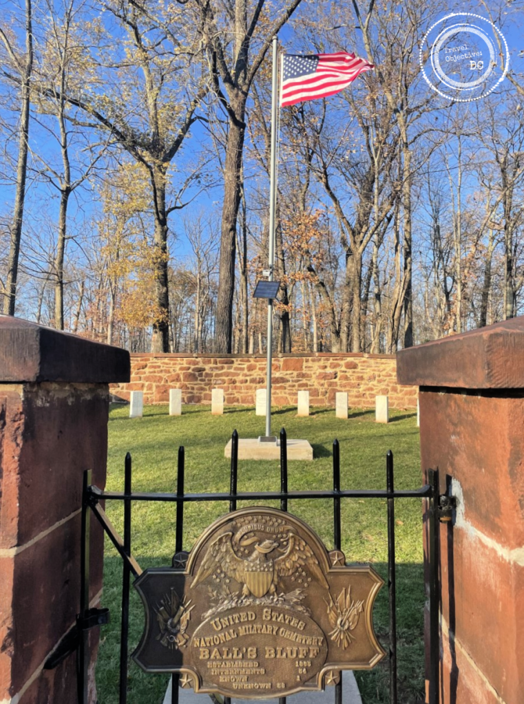
Today, the Alexandria National Cemetery remains a fine example of an early national cemetery aligning with Olmstead’s vision. Despite the cemetery’s urban location, it remains a quiet setting, save for airplanes coming and going from Reagan National Airport. A handsome brownstone building stands to the left of the main entrance marked by the ornate cast-iron gate found at the end of Wilkes Avenue.

The lodge was originally built as a cemetery superintendent’s home and office.

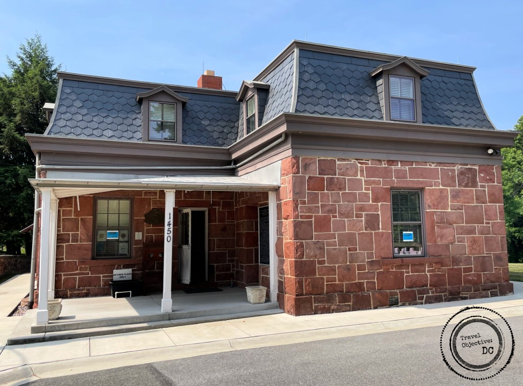
The building is based upon a design by architect Edward Clark and approved by Montgomery Miegs, the Quartermaster General of the Army during the Civil War. The design became known as the “Miegs Plan” and the buildings were intended for use as a superintendent’s home and office. Clark designed these lodges in the French Second Empire style using locally quarried Seneca sandstone to resemble other fashionable dwellings and office buildings built during this time. 

Only about twenty of these structures remain in national cemeteries today. The building currently houses office space and meeting rooms. A paper bound directory on the building’s porch assists visitors in locating specific graves. A redbrick annex at the back of the building is a converted restroom from the 1880s. 

Approximately 4,000 white stone markers spread out in orderly rows over the carefully manicured acres. The cemetery is currently closed to new internments (save for veterans or family members to be buried in an existing grave).

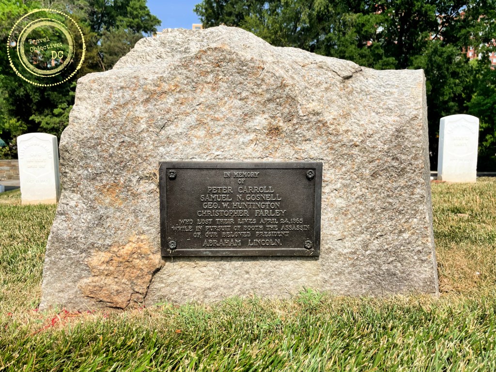
A paved roadway circumvents a central flagpole, flying the US flag. The graves of the four civilian firefighters who perished aboard the Black Diamond lie near the flagpole; a granite monument to their memory was added in 1922. 

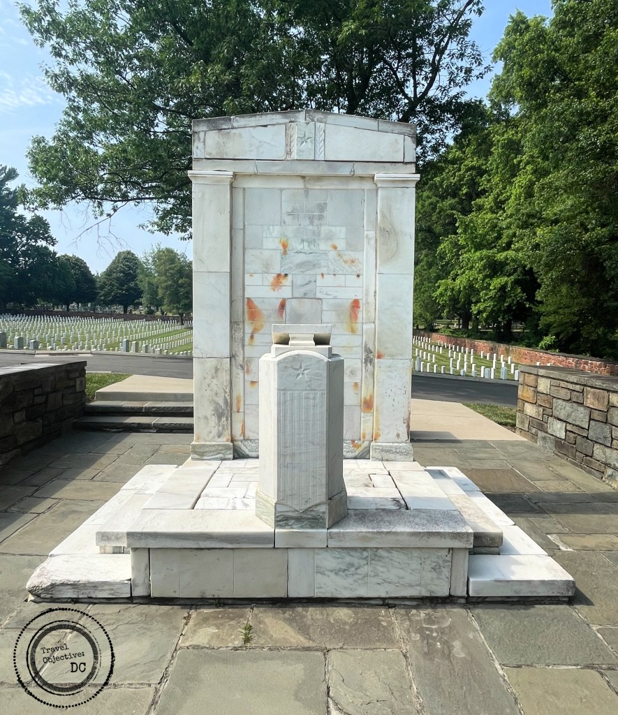
A marble platform with a podium and seating area replaced an older cast iron version in the 1940s. Meant for internment ceremonies, it is often used today for Memorial Day services. It is a convenient spot for pausing and contemplating the stories and sacrifices of those buried around you.  After spending some time on the grounds, it is clear that while the Alexandria National Cemetery is not as large nor renowned as its regional neighbor in Arlington, it is still a very active civic space for the people of Alexandria.

The Marble Rostrum

The grounds are perpetually cared for and remain neat and tidy. Walkers, joggers and bikers respectfully traverse the grounds, sometimes personally cleaning and tending to the stones. Visitors seek out specific graves, paying respects and leaving the occasional memento. Veterans groups meet at the lodge, planning their activities. Each Memorial Day, US flags are dutifully placed on the graves. Each December, evergreen wreaths grace the headstones. 

Through successive wars, the American custom continues of providing war dead, veterans and certain family members with a dignified burial in well-arranged cemeteries. Much of this work is done through volunteers who devote time and energy to enhance their community’s national cemetery. You can help keep this tradition alive and ensure your local national cemetery remains and active part of the community.

There are currently 171 national cemeteries in the United States and its territories managed by various federal agencies. All of them welcome volunteers to maintain these “sacred groves” as dignified and respectful burial grounds. Duties vary by location and range from administrative support, attending funerals, planning events and grounds work.

Volunteering At A National Cemetery

Of the 171 national cemeteries in the United States and its territories, 151 are administered by the Department of Veterans Affairs, 14 are managed by the National Park Service, and two by the Department of the Army. Internationally, 26 national cemeteries are managed by the American Battlefield Monuments Commission. 

More information on volunteering at national cemeteries can be found here:

Visit individual NPS National Cemetery websites for specific volunteer information.

ANC routinely looks for volunteers to collect wreaths following the the annual Wreaths Across America observance. Check the ANC website each December for more information. Other volunteer opportunities may occur through the year.

Route Recon

By car:

The Alexandria National Cemetery is located at 1450 Wilkes Street in Alexandria, Virginia. The gates to the cemetery are located at the end of Wilkes Street. 

There is parking along Wilkes Street. 

By public transportation:

The closest Washington DC area Metro Stop is King Street Metro Station. Take the DASH Bus #31 towards Braddock Road Metro. Exit the bus at the corner of King Street and Fayette Street. The cemetery gates are a .6 mile walk from this bus stop. Walk south on Fayette Street, then make a right onto Wilkes Street. The cemetery is at the end of the street. 

Alternatively, take the King Street Trolly from the King Street Metro Station. Disembark at West and King Streets. Walk one block east on King to Payne Street. Walk four blocks south on South Payne Street to Wilkes Street. Make a right on Wilkes Street. The cemetery is at the end of the street.

Cleared for Takeoff at the Steven F. Udvar-Hazy Center

The sliding glass doors retract and beckon you inside.  Passing the metal detectors, navy blue jacketed security officers nod a quiet greeting. Walk through a cavernous entryway and on to a balcony overlooking the massive Boeing Hanger. On the gallery floor the world’s fastest jet powered aircraft, the SR-71 Blackbird stares back at you, sleek and silent.  On the left, the toothy grin nose art of a P-40 Kitty Hawk welcomes you while an F4U Corsair dips its bent wing in a friendly gesture as if to say, “We’re glad you’re here, but you better get started. There is a lot to see!” Indeed, within the Steven F. Udvar-Hazy Center’s hangers are the products and byproducts of over two hundred years of aviation history. 

For anyone interested in aviation and space exploration, it doesn’t get much better than this.

For most visitors to the Washington DC area, the Smithsonian Institute’s National Air and Space Museum is synonymous with the building on the National Mall.  Currently undergoing renovation, that museum building can only hold a small portion of the Smithsonian Institute’s massive collection of artifacts and materials related to aviation and space travel. 

A US Coast Guard Sikorsky HH-52A Seaguard Helicopter

The Steven F. Udvar-Hazy Center is the other main component of the Smithsonian Institute’s National Air and Space Museum. Located in Chantilly, Virginia, it adjoins Washington Dulles International Airport. Conceived as additional space for the display of the Smithsonian’s extensive collection of aviation and space travel artifacts, it opened to the public in 2003. Between the National Air and Space Museum’s building on the National Mall and the Udvar-Hazy Center, approximately 80 percent large aircraft and spacecraft from the Smithsonian’s holdings are on display.

The center’s namesake Steven F. Udvar-Hazy is a Hungarian-born immigrant who came to the United States in 1958. A lifelong lover of aviation, Udvar-Hazy eventually became chairman of the International Lease Finance Corporation, one of the world’s largest aircraft leasing firms. He donated $66 million of his personal fortune to the Smithsonian for the purposes of building this impressive facility with its three main galleries: the Boeing Aviation Hanger, the James McDonnell Space Hanger and the Mary Barker Engen Restoration Hanger.  

The Boeing Gallery boasts nearly 200 aircraft in a space comparable to the flight deck on a Nimitz-class aircraft carrier.  Curators very carefully arranged the aircraft to maximize the available display space within the hanger. Organized into collections, the aircraft are situated either on the hanger floor or suspended from the ceiling. Balconies on multiple levels help visitors to see the meticulously restored aircraft up close.

The Air France Concorde FA, within the south side of the Boeing Hanger at the Udvar-Hazy Center.

The Udvar-Hazy Center features tours most days. Over 60 to 90 minutes, the volunteer docents lead visitors around the World War I fighters and reconnaissance aircraft, inter-war trainers and prototypes, Allies and Axis aircraft from World War II, early passenger airliners, experimental aircraft, general aviation planes, Cold War jets, helicopters and more. Some of the highlights of the collection include:

SR-71 Blackbird – The SR-71 is the fastest jet engine propelled aircraft. First flown in 1964, the operational performance and technological sophistication of the Blackbird is still impressive today. The centerpiece of the Boeing Gallery, the SR-71 Blackbird on display logged about 2,800 hours of flight time over 24 years. The U.S. Air Force donated this Blackbird to the Smithsonian. On its final flight, the Blackbird set a speed record flying from Los Angeles to Washington-Dulles International Airport in 1 hour, 4 minutes, and 20 seconds (about 2,124 miles per hour) 

B-29 Enola Gay – The Boeing B-29 Superfortress was first conceived in the 1930s as bomber with a greater range and capacity than the B-17. The B-29’s extended range of about 4,000 miles when loaded made it especially suitable for use in the Pacific Theater during World War II. On August 6, 1945, the Enola Gay dropped the first atomic bomb on Hiroshima, Japan.  

The Bell X-1 Glamorous Glennis

Bell X-1 Glamorous Glennis – On October 14, 1947, Captain Chuck Yaeger became the first person to fly faster than the speed of sound after he was drop launched in the X-1 from a B-29 Superfortress. He named the aircraft after his wife. 

F-14 D Tomcat – A naval fighter aircraft, this plane became well known to moviegoers following the release of the 1986 film Top Gun. 

Boeing 367-80 – The Boeing four-engine jet powered aircraft was the prototype for the US Air Force’s KC-135 tanker and the Boeing 707 jetliner. 

Concorde – The first supersonic airliner, the Concorde was flown by both Air France and British Air, serving customers willing to pay a premium for a faster flight. Unfortunately, higher fuel prices made the very sophisticated aircraft too expensive to operate. This Air France Fox Alpha Concorde on display was donated to the Smithsonian Institute on June 12, 2003 after its final flight from Paris to Dulles International Airport. 

The Space Shuttle Orbiter Discovery

Compared to the Boeing Aviation Hanger, the McDonnell Space Hanger, arrayed with satellites, rockets, probes and other cosmic equipment seems less crowded. However, one artifact stands out from all the rest, the Space Shuttle Orbiter Discovery.  Space shuttles were a unique reusable spacecraft, designed to take off like a rocket, land back on earth like a glider, and carry a variety of payloads. Discovery was the workhorse of the shuttle fleet, flying 39 missions and logging 365 days in space during its service life between 1984 and 2011.    

Displaying aircraft and space equipment is but one mission of the National Air and Space Museum. Before anything is placed into a hanger or gallery, museum preservationists painstakingly restore the aircraft and prepare it for its new life in the museum. Much of this refurbishment work is conducted in the Mary Baker Engen Restoration Hangar.

The large open hanger space accommodates several restoration projects at a time. An observation area on the mezzanine above the hanger floor allows visitors to watch the restorers at work.  One major restoration project currently underway in the hanger is on a Martin B-26B medium bomber from World War II named Flak-Bait. This bomber flew more than 200 missions over Germany from August 1943 until April 1945, more than any other American plane.

The Martin B-26B Bomber Flak-Bait holds the record for the number of bombing missions survived in World War II.

As captivating as they are, the Udvar-Hazy Center offers a few additional activities beyond just looking at the restored air and space craft. 

Observation Tower – The Donald Engen Observation Tower provides a commanding view of the area, including the main operational runways at Washington Dulles International Airport. Watch the planes take off and land throughout the day. The tower also includes a quick lesson in the functioning of the air traffic control system, adding some helpful context to the highly choreographed movement of aircraft through the region’s airspace.  

Simulators – After viewing so many exciting aircraft, a collection of simulators provides the realistic feeling of taking to the skies and beyond.  

Theater – The Airbus IMAX Theater at Udvar-Hazy, the largest in Northern Virginia, shows a combination of current Hollywood releases as well as documentaries on different aspects of aviation and space exploration.

Additionally, the Smithsonian maintains a regular schedule of educational programs, lectures, and events for young people, such as the annual Air & Scare held the Saturday before Halloween. 

The B-29 Superfortresss Enola Gay.

After a visit, it is easy to understand why the Udvar-Hazy Center is one of the top destinations not only in the Washington, DC area, but in all of Virginia. The building is expansive, easy to navigate and the exhibits are tantalizing to the eye with multiple legendary air and spacecraft on display. Beyond the artifacts, other aviation related activities are available to expand your understanding of flight and helpful staff are available to answer questions. For admirers of aviation, adventure or innovation, there are few better places (on the ground) to spend a day than the Steven F. Udvar-Hazy Center

* * *

Route Recon

The Steven F. Udvar-Hazy Center is located just south of Washington Dulles International Airport, along Virginia Route 28 in Chantilly, Virginia. 

The address is: 14390 Air and Space Museum Parkway, Chantilly, VA 20151

By car:

From Washington, DC, and points south: Take Interstate 66 West to Route 28 North (Exit 53B): Travel on Route 28 North for 5.3 miles. Exit at Air and Space Museum Parkway and follow the signs to the Udvar-Hazy Center.

From Washington, DC, and points north: Take Interstate 495 West (the Capital Beltway) to the Dulles Toll Road West (Virginia Route 267). Exit the toll road at Route 28 South (Exit 9A) and travel south 3.5 miles. Exit at Air and Space Museum Parkway and follow the signs to the Udvar-Hazy Center.

NOTE: Online mapping apps may direct you to enter the Udvar-Hazy Center from US Route 50. This is not a public entrance. You must enter from Virginia Route 28. 

Admission to the museum is free, but parking costs $15 before 4:00 pm. Free parking is available for all cars arriving after 4:00 pm.  Vehicles dropping off or picking up visitors are not charged if staying less than 30 minutes. 

By Bus: 

From Washington Dulles International Airport to the Udvar-Hazy Center in VA:

From Ground Transportation bay #5E (lower level exit #6), take Fairfax Connector No. 983 one stop to Steven F. Udvar-Hazy Center. Buses run every 25 minutes during peak times and every hour during non-peak times and weekends. Bus fares paid with SmarTrip card or cash. Bus drivers do not carry change. The bus ride from Dulles Airport takes approximately 25 minutes. 

By Metro: 

Take Metro Silver Line to Innovation Center station. 

Fairfax Connector provides connecting bus service from the Silver Line’s Innovation Center Metro station. More information is available on the Fairfax Connector No. 983 website Buses run every 25 minutes during peak times and every hour during non-peak times and weekends. Trips between Innovation Center and the Udvar-Hazy Center take about 12-15 minutes.

Exit bus at Steven F. Udvar-Hazy Center stop.

Plan for an approximately 1 hour and 35 minute trip from Washington, DC to the Udvar-Hazy Center using Metro. 

Mess Call

Shake Shack restaurant provides onsite dining at the Udvar-Hazy Center. The Shake Shack is open from 11:00 am to 5:00 pm daily. The restaurant serves burgers, hot dogs, chicken sandwiches, fries, frozen custard, shakes, and coffee. There are two shakes exclusive to the museum, the Constellation Crunch Concrete and Out of This World Shake. Additionally, pre-packaged salads and sandwiches are available from an automated vendor kiosk. 

Walking Through History at Ball’s Bluff

Battles always beget consequences. The Battle of Ball’s Bluff was a small battle by Civil War standards. Yet this devastating defeat for the Union affected the conduct of the war for years to follow.

A visit to Ball’s Bluff Battlefield Regional Park in Leesburg, Virginia helps clarify how inexperience, miscommunication and a lack of planning all contributed to the Union defeat. At the same time, the natural setting adjacent to the Potomac River offers beautiful views and is a popular site for local residents to walk their dogs and explore nature.

Today, the NOVA Parks (formerly the Northern Virginia Regional Park Authority) maintains much of the battlefield. Ongoing efforts have restored the land to a resemblance of its wartime appearance as an open meadow surrounded by woodlands atop a shale and sandstone bluff, some 100 feet above the Potomac River.  The location is notable too as the site of the third smallest national cemetery in the United States.

A map of the Battle of Ball’s Bluff by J. Wells from an 1887 publication.

Leesburg, Virginia, the county seat of Loudoun County, is a vibrant community with a historic downtown surrounded by residential districts. As an exurb of Washington, DC, the town’s population has grown steadily over the past several decades. When the Northern Virginia Regional Park Authority first acquired the battlefield land outside the cemetery in 1986, it likely preserved the land from the development that has enveloped much of Northern Virginia. Through the years, adding adjoining parcels brought the current park area to over 200 acres.

In 1861, as it is today, Leesburg was an important crossroads. The Confederates garrisoned a brigade at Leesburg commanded by Colonel Nathan “Shanks” Evans – a hero of the First Battle of Manassas. On October 17, 1862, Colonel Evans completed an unexpected withdrawal from Leesburg.  His departure caught the attention of the overall Union commander, Major General George McClellan. However, word of his brigade’s return several days later did not reach McClellan.  

Brigadier General Charles P. Stone

-Library of Congress, Prints and Photographs Division, Civil War Photographs

On October 20, 1861, McClellan ordered Brigadier General Charles P. Stone to verify if rebel troops were still in Leesburg. McClellan suggested a “slight demonstration” by Stone’s men might determine if the Confederates had returned. Stone ordered artillery fire and an infantry patrol, but there was no sign of Confederate troops. Finally, around dusk, he sent a detail of about 20 soldiers from the 15th Massachusetts Infantry Regiment across the river to establish if there was indeed a rebel presence in Leesburg.

Leading the effort was a newly commissioned officer, Captain Chase Philbrick. Captain Philbrick used three small boats to cross the rain-swollen Potomac River below Ball’s Bluff. Once on shore, he led his men up a steep, narrow trail to the top of the bluff. Marching about a mile through the darkness, Philbrick saw a row of trees he thought to be a confederate camp. Without further confirming his suspicions, the patrol returned across the river and relayed a report of an enemy encampment to General Stone.

This incorrect report would precipitate the Battle of Ball’s Bluff.

The Ball’s Bluff Battlefield Park is accessed on the aptly named Ball’s Bluff Road, which quickly transforms from a neighborhood street to a gravel road as it enters a wooded area. The Battlefield Park sign is assurance you are indeed in the right location. 

Ball’s Bluff Road continues through the woods and terminates at the parking area.  An orientation station adjacent to the parking lot provides a seating area and signage to familiarize the visitor with the early days of the Civil War, period life in Loudoun County and details on the origins of the battle.

From the orientation station an old road known as the Cart Path leads through the woods and into the open meadow towards the cemetery. This Cart Path was likely the route Captain Philbrick’s patrol took in search of the rebel camp. It is not hard to imagine what these soldiers could have felt as they made their way through the Virginia darkness. Being far from home, only recently in uniform and now in Confederate territory, it probably seemed rebel soldiers were behind every tree.

The Cart Path as it cuts through the meadow at Ball’s Bluff Battlefield Regional Park.

The Cart Path is only one of seven different trails that lace through the park. The main Battlefield Interpretive Trail is a .8 mile loop that circumvents the open field and provides access to principal historical features found in the park. Access the Interpretive Trail where it intersects the Cart Path at the entrance to the open meadow.  Abundant signage along the trail provides background on the leaders and units who engaged at Ball’s Bluff.

As the trail approaches the edge of the bluff, it passes an overlook with vistas (depending on the foliage) over the river and into Maryland. From the overlook, a water tower in the distance marks Poolesville, Maryland where General Stone had his division headquarters. During the battle, Stone moved much closer to the river, but he would never have timely information on what was happening on Ball’s Bluff. 

The Interpretive Trail then leads down to river’s shore. The climb down to (and back up from) the river can be a bit strenuous. Sturdy shoes are essential, but the trek is well worth it. At the river’s edge, the geographic challenge and its ramifications for the Union Army at Ball’s Bluff becomes quite apparent.

Harrison’s Island, viewed from the shore below Ball’s Bluff.

About 80 yards from the Virginia shoreline is Harrison’s Island. The island served as a staging area for Union forces moving to Ball’s Bluff. Union forces crossing the river here needed to rely on boats. Unfortunately for the Union, a courier’s inaccurate report to a battalion commander led to the use of the Harrison Island crossing rather than more shallow fording areas in the vicinity. Since the amphibious river crossing was unplanned, boats were in very short supply. Additionally, the Potomac River has swift moving currents not always visible on the surface adding difficulty to any river crossing.

After receiving Captain Philbrick’s report of an enemy camp, Stone ordered Colonel Charles Devens to prepare a raiding party. Devens and approximately 300 men from his 15th Massachusetts Infantry Regiment crossed the Potomac River early on the morning of October 21st.

At about 6:00 AM, Devens’ soldiers completed their river crossing and began climbing the same steep and narrow path as the Interpretive Trail up to Ball’s Bluff.  They marched to the supposed camp location but soon discovered no rebel camp existed. While awaiting further direction, they encountered a Confederate patrol around 8:00 AM and the battle was soon underway.  Skirmishing between Union and Confederate units continued through the morning.

Colonel (and U.S. Senator) Edward Baker

-Photograph ca 1861 by E. & H.T. Anthony

Throughout the afternoon, troops deployed in a rather disjointed fashion, further hindered by delayed and sometimes confused communications. The limited number of available boats and the narrow trail up and down the cliff also limited the movement of the Union soldiers.  

Returning onto Ball’s Bluff, the trail winds away from the cliff’s edge and into the meadow. It passes a memorial marker to Colonel Edward Baker. After the initial reports of combat, General Stone selected Colonel Baker to take command of the Union forces engaged on Ball’s Bluff between 9:00 and 10:00 AM.  Baker seemed a natural choice. He was a longtime friend of President Lincoln and a sitting United States Senator from Oregon. He had served in the Black Hawk War and commanded at the Brigade/Regiment level during the Mexican-American War. He also raised a volunteer regiment for Union service.  

However, it would take Baker over four hours to make his way to Ball’s Bluff as he set about procuring additional boats to support the river crossing. Once on Ball’s Bluff, Baker displayed great nerve under fire. However, his maneuver plan failed to suppress the enemy and opportunities to take the initiative during the fight were lost. Baker was killed by enemy fire at about 5:00 PM. 

The marker denoting the death of Colonel Edward Baker at Ball’s Bluff Battlefield Regional Park.

As evening was drawing in, Confederate units began surrounding the Union troops who were caught with their backs to the cliff.  There were several attempts to break through the rebel lines towards the south, where the river crossing would be simpler, but they were unsuccessful.

Union troops began withdrawing down the cliff en masse. Several units valiantly slowed the Confederate advance, but the withdrawal became a rout. Panicked soldiers ran down the cliff. Some surrendered, others jumped into overcrowded boats or directly into the water. Rebels pursued the Union soldiers to the cliff’s edge keeping them under fire. Boats capsized and many Union soldiers drowned. The swift river currents carried the deceased away, some even beyond Washington to Mount Vernon.

Union losses at Ball’s Bluff were considerable: 223 soldiers were killed and 226 wounded. An additional 553 were captured or missing. Confederate losses were notably less, at about 36 men killed, 264 wounded and 2 missing.

Numerous accounts of the Union defeat at Ball’s Bluff were carried in newspapers across the North and the South. The coverage was extensive given Leesburg’s proximity to Washington and its occurrence only 90 days after the defeat at Manassas. The stinging defeat and high number of casualties, including the very popular Senator Baker, led to Congressmen and Senators forming the Joint Committee on the Conduct of the War to investigate several Union Army defeats, including Ball’s Bluff. After several hearings, the committee identified General Stone responsible for the loss. He was suspected of disloyalty and arrested. He was imprisoned without a trial and held for 189 days. Stone’s ordeal was a warning to other Union generals, who then became overly cautious in their decision making and planning of combat operations.  

After the battle, Confederate troops removed their dead to Leesburg. A Union burial detail temporarily interred Union remains in a mass grave on the battlefield. Both sides returned many identified remains to their hometowns for burial. After four years, the U.S. Army established a national cemetery on Ball’s Bluff and buried the last 54 remains still interred on the battlefield. Within the cemetery’s stone wall, 25 markers are arrayed around a flagpole. Only one soldier is identified, Private James Allen of the 15th Massachusetts.

Gravestones surrounding the flag pole at the Ball’s Bluff National Cemetery

Today, Ball’s Bluff Battlefield is a National Historic Landmark. NOVA Parks strives to maintain the park as a natural setting, while at the same time providing the visitor with the means to understand the tragic events of the battle, their causes and their consequences. That work goes beyond the park’s signs, monuments and markers. A NOVA Parks sponsored organization, the Friends of Ball’s Bluff, provides volunteer guides to lead tours of the battlefield on weekends from April until November. Each year around the battle’s anniversary, the park hosts a heritage day with re-enactors and living history displays. An annual dinner recognizes the efforts of the Friends of Ball’s Bluff and their commitment to the park while raising funds for park restoration work. 

There are many Civil War historical sites throughout the Washington DC area. However, in a short visit of only a few hours, Ball’s Bluff’s excellent conversation and interpretation of the battle provides valuable insights for anyone interested in a deeper understanding of the American Civil War. Coupled with other historical and cultural attractions in Loudoun County, a visit is well worth the time on anyone’s travel itinerary.

Route Recon

Ball’s Bluff Battlefield Regional Park is located on Ball’s Bluff Road in Leesburg, Virginia.

Please note there is no visitor center, restrooms or trashcans at Ball’s Bluff Battlefield Park. 

Find more information about the park, park activities, hiking trails and the Friends of Ball’s Bluff at the NOVA Parks Website.

Command Reading List

These three resources provide extensive background on the Battle of Ball’s Bluff.

A Little Short of Boats; The Battles of Ball’s Bluff & Edwards Ferry – By James A. Morgan III

James Morgan was a local resident and volunteer guide at Ball’s Bluff Battlefield Park. His book examines McClellan’s strategy regarding Leesburg, the unique personalities among the leaders involved and the unintended consequences of many of the command decisions.

Battle at Ball’s Bluff – By Kim Bernard Holien

This book uses extensive historical resources and first person accounts to describe the battle. Published in 1985, it describes the rugged condition of the battlefield before the Northern Virginia Regional Park Authority assumed control of the land.

U.S. Army Staff Ride Guide, Battle of Ball’s Bluff – By Ted Ballard

The U.S. Army’s official staff ride guide provides an extensive account of the battle, leaders, and decision making, with an emphasis on the lessons learned in small unit actions, tactical planning and leadership.