
In 1590, Captain John White eagerly sailed from England anxious to return his family and friends living on Roanoke Island, a barrier island part of today’s Outer Banks of North Carolina. Due to a war with Spain, three long years had passed since his departure to procure additional resources for the fledging settlement. Upon his return however, he found the dwellings and working areas abandoned. There were no signs of the English settlers. The only clues were two inscriptions; CROATAN on a wooden post and CRO carved into a tree. White never learned what happened to his community and the search for their fate continues today.

An engraving from the 1870’s depicting Captain John White’s return to the Roanoke Colony.
-Design by William Sheppard; engraving by William James Linton.
Modern visitors to Roanoke Island can learn more about the “Lost Colony” at the Fort Raleigh National Historic Site, located on the northern end of Roanoke Island, near Manteo, North Carolina. The site’s large open green spaces and broad ribbons of wooded areas are a stark contrast to the sand of the Outer Bank’s renowned beaches.
Fort Raleigh was designated a historic site in 1941 after archeological evidence confirmed the English colonists once occupied a portion of the land. Today there is a modern visitor center, renovated in 2015, with exhibits about the history, archeology and artifacts of the early settlement. Some recent discoveries include fragments from ointment containers, olive jars and indigenous pottery.
Reproductions of maps and illustrations drawn by Captain John White hang on the historical wood paneling in the Elizabethan Room.
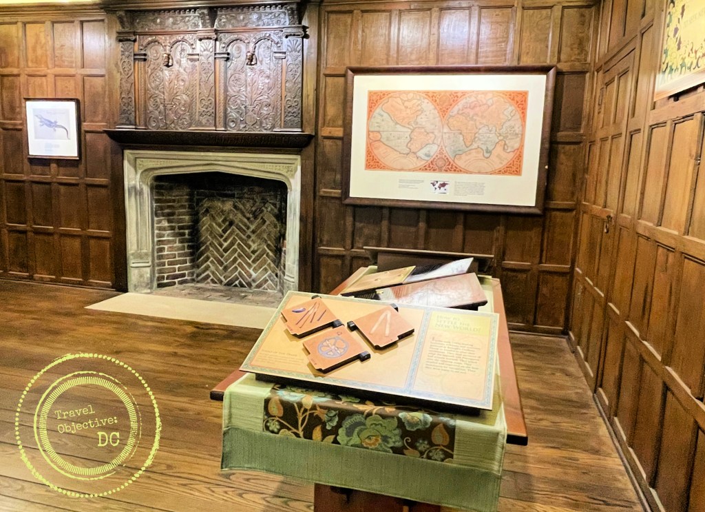
An “Elizabethan Room” within the visitor center is decorated with intricately carved wood paneling from an actual Elizabethan-era English manor house. The room features an innovative electronic display that dramatizes the circumstances and conversations of Roanoke Colony leaders, investors and settlers. The scenes offer some intriguing insights into Captain John White’s intent to leave England for North America and his hopes for the future. A 17-minute film in the visitor center theater provides additional context on the settlers’ lives. A reconstructed earthen fort depicting the original Fort Raleigh’s walls lies a short walk from the visitor center.
Although it did not happen on the grounds of Fort Raleigh, the National Historic Site also interprets the story of the Civil War Battle of Roanoke Island, an early and strategic Union victory during a time when Confederate forces appeared ascendant.

US Army Brigadier General Ambrose Burnside won a decisive victory on Roanoke Island in February 1862.
After Federal losses in 1861, Union strategists and planners identified the thinly defended North Carolina coast for a military operation. Roanoke Island was identified as the principal objective. If Roanoke Island could be taken, then shipping to and from the port cities along the North Carolina coast and Norfolk, Virginia could be blocked. Union Brigadier General Ambrose Burnside, with the support of his boss Major General George McClellan, began assembling a “coast division” capable of landing on and occupying Roanoke Island. The division would then establish a foothold for further action in eastern North Carolina.
Burnside recruited 14 infantry regiments (approximately 13,000 troops) for his division. He also contracted a large fleet of private commercial ships to transport his troops. In an early example of a joint forces’ operation, Burnside coordinated closely with US Navy Flag Officer Louis Goldsborough. Goldsborough’s flotilla would subdue Confederate warships and pepper coastal fortifications with covering fire in advance of Burnside’s ground operations.
View of Ashby’s Harbor looking west, where Union forces landed on Roanoke Island.
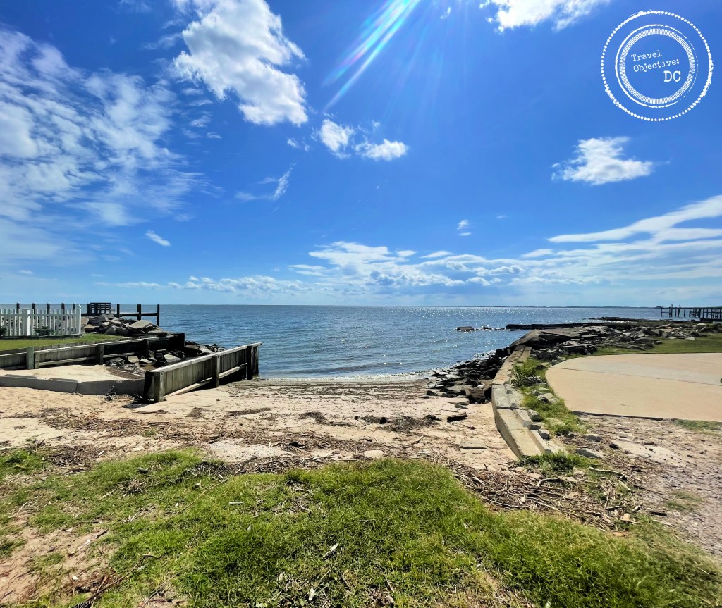
Through the afternoon and into the evening of February 7, 1862, the Union Army landed 11,500 men at Ashby’s Harbor, on the western side of Roanoke Island. This was one of the US Army’s first amphibious operations in hostile terriroty. After a rainy night, the division’s three brigades marched east through swampy and difficult terrain.
Confederate forces established their defensive line along the island’s main road to the northeast, centering it on a battery of three field guns. As Union brigades deployed, they attacked the Confederates on the left, right and the center. The rebels were soon overwhelmed and withdrew to the north. However, with no way to leave the island, they ultimately surrendered. The Union Army captured over 2,500 soldiers along with 42 artillery pieces and large quantity of small arms.
After taking Roanoke Island, Burnside then moved against other port cities through the spring. By summer, the cities of New Bern, Beaufort, Fort Macon and even Norfolk, Va., had all fallen to Union forces.

Battle of Roanoke Island historical marker.
Another significant outcome of the battle was a surge in the African American population on Roanoke Island. Considered “Contraband of War” by the Army, enslaved African Americans were emancipated as they entered Union controlled territory. As the numbers of arriving African Americans steadily rose, the Army confiscated local land to provide an area for the newly freedmen to settle and established a Freedmen’s Colony in 1862.
A chaplain from the 25th Massachusetts Volunteer Infantry Regiment named Horace James was placed in charge of the colony. Reverend James was a skilled organizer and administrator, focusing the colony’s efforts on supporting the Union Army. In exchange for rations and wages, newly freed African Americans worked in a variety of jobs such as carpenters, blacksmiths, stevedores, fishermen, or as domestic staff. The more daring served as scouts, spies and guides, gathering critical intelligence and accomplishing important missions.
This stone memorial was placed at the Fort Raleigh National Historic Site to commemorate the Freedmen’s Colony.

During the war, the colony kept growing with a total population reaching almost 4,000 at its peak. A lumber mill was built, along with schools, churches and over 500 houses. After the war though, Federal policy returned impounded lands back to the original owners. Most of the freedmen moved away, although some remained. The colony was officially dissolved in 1867. Today a granite marker at the historic site commemorates the Freedmen’s Colony and the refuge it provided on Roanoke Island.
The attraction of Fort Raleigh is more than its displays and stories of the past. Indeed history on Roanoke Island is kept very much alive.
Adjoining Fort Raleigh is the Elizabethan Gardens, an initiative of the Garden Club of North Carolina. The brick gatehouse serves as a portal to a collection of different types of gardens inspired by the Elizabethan era and beautifully arranged over ten lush acres.
The garden’s design combines trees, shrubs and flowering plants carefully selected and placed so that seasonal variations result in a constantly changing appearance. Italian statuary from the Renaissance period is displayed throughout the gardens adding to the classical look and feel. One of the garden’s main features is a massive 400-year-old oak, a living connection to the earliest English colonial times and the four and a half centuries that followed.
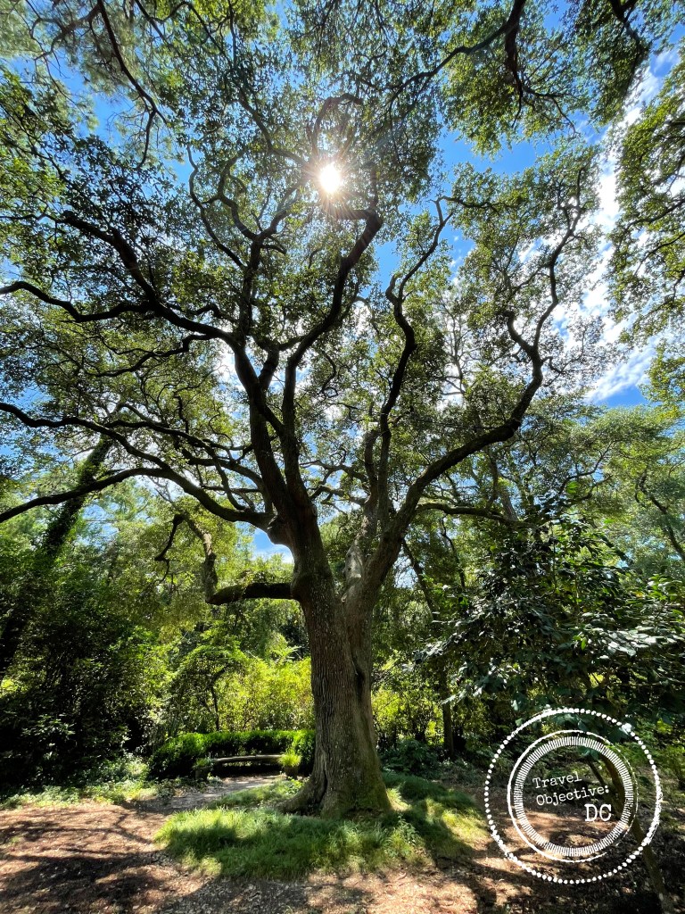
An ancient oak tree in the Elizabethan Gardens which grew during the times of the “Lost Colony”.
Forth Raleigh also houses the Waterside Theater, home of the long running production of The Lost Colony. Now in its 86th season, the outdoor play is one of the most prominent cultural experiences on the Outer Banks. More than just a drama, the story of the early English settlers is told with music and dancing, along with comedy, fight scenes and a dash of English pageantry.
Although it has seen some modifications through the years, the Roanoke Island Historical Society, producer of The Lost Colony, used the pause due to the recent pandemic to rework portions of the production. A special focus was the portrayal of Native Americans. The Historical Society worked with the local Lumbee tribe to ensure the Native American characters’ dialogue and dance scenes are accurate. Additionally, all actors playing Native Americans on stage have indigenous heritage. More modern staging effects have also been incorporated; 3-D images projected onto the stage sets provide very realistic backdrops to scenes set in gardens, forests and onboard ship. Audiences have enthusiastically returned, keeping The Lost Colony an Outer Banks tradition.
Each year millions of people visit the Outer Banks. They come for the beach life, water sports, ocean breezes and the wild horses on Corolla. Some also come for the history, as history abounds on the Outer Banks. They come for stories of the Wright Brothers, pirates and the U.S Live Saving Service. Add some history to your Outer Banks trip with a visit to the Fort Raleigh National Historic Site, where Outer Banks history is carefully preserved and made relevant for today.
* * *
Route Recon
Fort Raleigh National Historic Site is located on the north end of Roanoke Island, about four miles north of the town of Manteo, North Carolina. The Visitor Center address is 1500 Fort Raleigh Road, Manteo, North Carolina 27954. The phone number is 252 473-2111. Call ahead for information on daily historical talks.
The Elizabethan Gardens is located at the Fort Raleigh National Historic Site. The address is 1411 National Park Drive, Manteo, North Carolina 27954. The gardens are also a short walk from the Fort Raleigh Visitor Center. Visit the Elizabethan Gardens website for more information, including current admissions rates.
The Waterside Theater, home of the The Lost Colony production, is located at 1409 National Park Drive, Manteo, North Carolina 27954. Visit The Lost Colony for more information on scheduling and ticket pricing.
Ashby’s Harbor is located at the end of Skyco Road about 4.5 miles from the Fort Raleigh National Historic Site. From the Visitor Center, head south on US Route 64 past the village of Manteo. Continue straight at the intersection with North Carolina Route 345. After .7 miles, make a right onto Skyco Road.
The Historical Marker for the Battle of Roanoke Island is located on the southeast corner of the intersection of US Route 64 and North Carolina Route 345. There is a small parking area on the southside of the intersection. This is a busy intersection so use caution when viewing the marker.
Mess Call
The Hungry Pelican is a local Manteo deli offering excellent sandwiches as well as salads, ice cream and great desserts. The Hungry Pelican is located at 205 Budleigh Street in the historic center of Manteo. Visit their website for menus and operating times.
