Walking Through History at Fort Washington

On a hot summer day, five authentically dressed men reenact a 19th century US Army artillery detail. The solider in charge of the detail, or gunner, calls the commands while the cannoneers crisply and meticulously execute the drill. The highly polished barrel of the M1841 mountain howitzer shines brightly in the sun. The gunner shouts the final command: Fire! A cannoneer pulls the lanyard, a spark ignites the powder charge within the cannon. Brilliant flashes of flame shoot from the breech of the cannon’s barrel.  Booms echo off the brick walls while smoke fills the sultry air.

National Park Service volunteers reenact a 19th century cannon drill at Fort Washington.

The reenactors are National Park Service volunteers demonstrating the skills of artillery soldiers at Fort Washington Park in suburban Prince George’s County, Maryland, just east of Washington, DC. Mention Fort Washington Park to an area resident and you are likely to get a blank stare or a vague reference to the local neighborhood of the same name. Many are unaware of this national park, hugging the eastern shore of the Potomac River just south of Alexandria, Virginia. Indeed, a recent sunny day found mostly local residents visiting the park, jogging, walking dogs and biking along the park’s avenues and trails. 

The story of Fort Washington is really the story of four different forts spanning almost 140 years. The first three of which were built specifically to defend Washington, DC from an enemy naval attack via the Potomac River. In today’s era of jet aircraft and precision guided missiles, we do not think much about coastal defense. Yet in the first 150 years of the United States, it was an important strategic and sometimes political issue. 

The Fort Washington Park Visitor Center building was originally the post commander’s quarters. It dates from 1822.

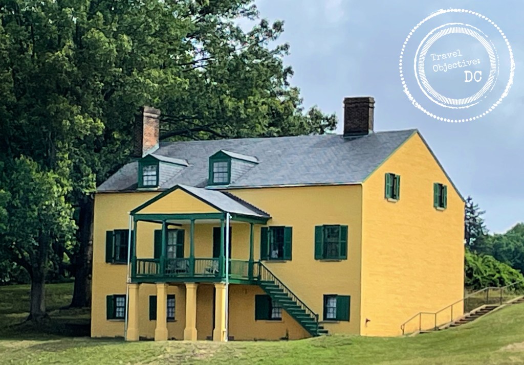
The Fort Washington Park Visitor Center is the worthwhile first stop for new visitors to Fort Washington.  Housed in the original post commander’s quarters, the visitor center provides helpful background on how America’s approach to coastal defense changed through history. Displays detail nearly 140 years of Army life at Fort Washington, describing the four different forts, the various weapons deployed as well as the different Army units posted here. Make sure to step out onto the back deck. The commanding views of the Potomac River reveal why this location was selected for Washington, DC’s defense. 

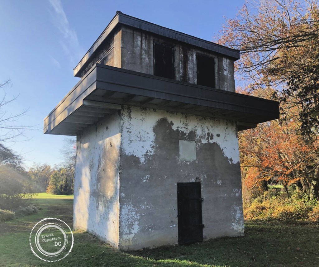
Near the visitor center, two concrete relics are reminders of the “third” Fort Washington. After the Civil War, the world’s navies began building warships with iron and steel, rather than wood. In the 1880’s, the Army developed the Endicott System for coastal defense which included concrete structures and rifled guns and other armaments that could penetrate the armored plating of these new combat vessels. 

The present day ruins of Decatur Bunker.

Between 1891 and 1902 the Army built a series of eight concrete bunkers around Fort Washington to position these weapons. Adjoining the parking lot is Decatur Bunker. While today is looks like a set for a post-Apocalyptic movie, it was originally built to house two 10-inch “disappearing guns” named because the cannons would drop down behind the bunker wall after firing, allowing for safe reloading. 

The bunkers were electrified and had telephones connected to a central tower where an officer directed the fire of the batteries as necessary. The Fire Control Tower is located right next to the visitor center.  Although the bunkers are visible, they are fenced off and entry is prohibited. However, similar Endicott System bunkers across the Potomac River at nearby Fort Hunt in Virginia are open for public exploration.   

The Fire Control Tower

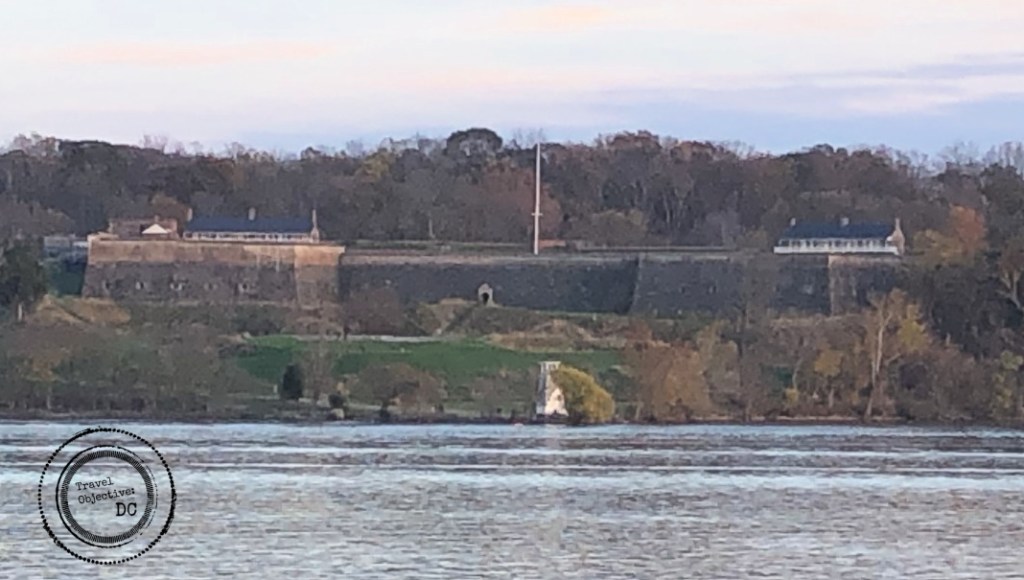
A short walk from the visitor center is the “second” Fort Washington, the main attraction at Fort Washington Park today. Built after the War of 1812, it was finished in 1824, but largely unused until a renovation in the 1840’s allowed the fort to be sufficiently armed. 

Approaching the main gatehouse with a dry moat and large drawbridge, the fort feels almost medieval. But it really is the product of careful military engineering reflecting the defensive technology and combat tactics of the time. The fort is distinctive as one of the few remaining coastal fortifications in its original form.

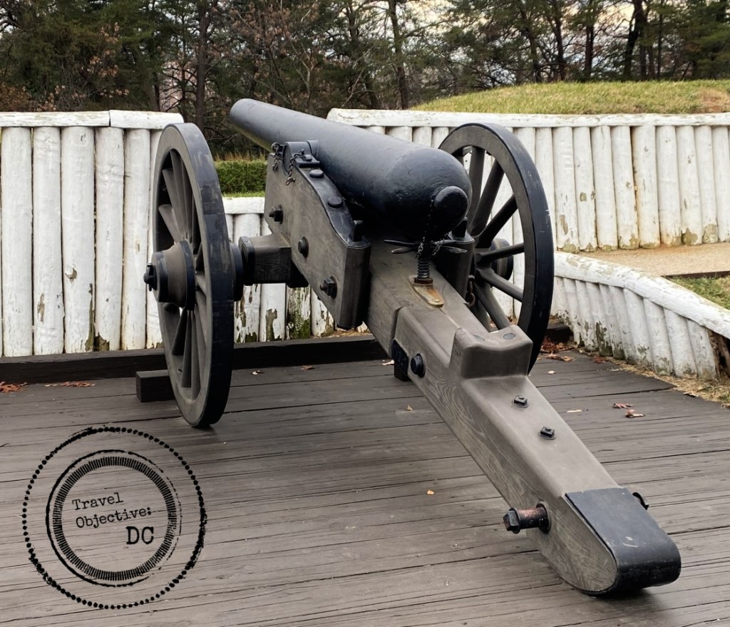
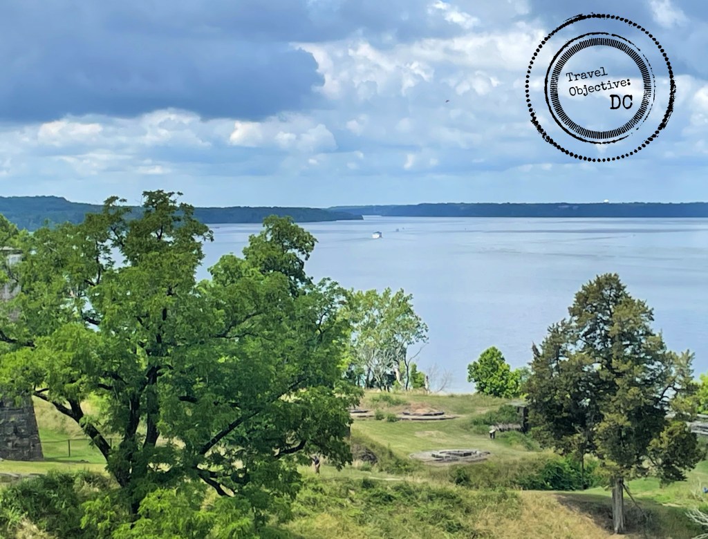
Designed to thwart attacks by land as well as by water, the fort’s massive brick walls have many angles and turns so defending solders could have multiple positions to fire on attackers. Parapets on the western wall facing the river provided firing positions for the sizable cannons to engage enemy ships. Several types of cannons in use at the fort are on display, including an original 24-pounder cannon so named because the solid cannonballs it fired weighed 24 pounds (with a range of 1900 yards)! 

The parade field at Fort Washington. Note the enlisted barracks building on the left and the 24 pounder cannon on the right.

A large parade field dominates the interior of the fort. The parade field was a center of daily life for the soldiers. Here troops would parade, stand inspections, answer daily roll calls, organize work parties, and conduct drills.  Adjoining the parade field are two long brick buildings, one housed officers and their families, the other was the enlisted barracks.  

A left turn down the hill from the fort’s main gate leads to the river and an area known as Digges Point. In the century before the Army built fortresses on this ground, the Digges family, transplants from Virginia, maintained a tobacco plantation named Warburton on today’s parkland. Thomas Digges was a contemporary and friend of his neighbor George Washington. George and Martha Washington regularly visited Warburton, traveling by riverboat from Mount Vernon and disembarking at Digges Point. A US Coast Guard channel marker stands in the area today.

The Potomac River looking south from Fort Washington.

As concern about another war with Britain continued growing in the early 1800’s, Congress allocated money for a system of fortifications to protect the Eastern Seaboard. The Army built the first fort near Digges Point in 1809. Originally known as Fort Warburton, it had 14-foot-high brick walls and up to 26 cannons. 

Unfortunately, Fort Warburton did not fare well in its first and only engagement. On August 27, 1814, a ten ship Royal Navy flotilla sailed up with Potomac River towards Alexandria. A day earlier, Washington, DC had been attacked and burned by other British forces. With only enough soldiers to crew five cannons, and sensing defeat, the fort’s commander, Captain Samuel Dyson took drastic action.

He ordered the cannons be destroyed, the magazine with all its black powder blown up, and the garrison to withdraw. The magazine’s explosion left most of the fort heavily damaged before Royal Navy guns destroyed the rest. Not surprisingly, Captain Dyson’s chain of command considered this a very poor decision. He was courtmartialed and dismissed from the Army. There is not much of the original fort remaining today, but its original location on a grassy, level piece of ground near Digges Point is evident.

The introduction of the airplane in World War I made the idea of large forts with cannon for coastal defense obsolete. In the decades following the war, the fourth Fort Washington served as a garrison for the 3rd Battalion, 12th Infantry Regiment, the Army’s ceremonial unit (a role played by the 3rd Infantry Regiment today). During World War II, the Adjutant General Corps located its training school at Fort Washington and the 67th Women’s Army Auxiliary Corps detachment also called it home.  

There are few remaining buildings from this time. In 1946, Fort Washington was turned over to the Department of the Interior to become a national park and over 300 buildings were removed.

This brick building served as a post exchange and gymnasium. It is one of the few surviving buildings at Fort Washington from the 20th Century.

With the soldiers long departed, Fort Washington’s mission today is to provide a place for recreation. Beyond history, the park’s expansive green spaces and proximity to the water provide a unique natural setting. Several walking trails traverse the grounds with varied habitats. Bird and wildlife are abundant. Watch for deer, foxes, and raccoons. In the open areas, a variety of songbirds can be observed while bald eagles, osprey, herons, and mallards are seen along the river. Fishing is an option as well with dozens of fish species in the adjoining waters. 

While the Washington region teams with many significant sites in US military history, Fort Washington is unique. Where other sites are related to a single event or era, Fort Washington chronicles the period from wooden ships to World War II. A “must see” for those interested in defensive fortifications, Fort Washington is also a most pleasant place to spend some quiet time on the Potomac River. So, pack a picnic, bring your binoculars for the views, and walk through some history at Fort Washington. 

* * *

Route Recon

The Fort Washington Park Visitor Center and the historic fort are open Thursday – Sunday from 9:00 am – 4:30 pm, except on Christmas and New Year’s Day. The Visitor Center and historic fort are closed on Monday, Tuesday and Wednesday. 

The park grounds are open through sunset each day. From October – April, park grounds open at 8:30 am. From May – September, park grounds open at 6:30 am. 

Fort Washington hosts living history as well as conservation programs on a recurring basis. Check the Fort Washington Park website for more information and schedules.  

There is no charge to visit Fort Washington. 

A State of Maryland fishing license is required to fish at Fort Washington. 

Fort Ward, the Mission Continues

Six Civil War reproduction cannons stand as silent sentinels over the Fort Ward Museum and Historic Site, an open and inviting space in Alexandria, Virginia, Washington, DC’s neighbor to the south. The site, located in Alexandria’s Seminary Hill neighborhood, was originally conceived as a Civil War era preservation project. Today, Fort Ward is embracing over 150 years of history, from the Civil War through the Civil Rights era, for this prominent and storied Virginia city.

Fort Ward’s origins are found in the days following the rebel victory at Manassas in July of 1861.  U.S. Government leaders quickly realized the Federal capital was in a precarious situation. Bordered on one side by Virginia, now enemy territory, and the other by Maryland, a slave holding state, Washington, D.C had almost no physical defenses to rely on.

Cannon - Fort Ward - Alexandria VA - Civil War defenses

The Army appointed one of its leading engineers and an expert on coast artillery, John Barnard, to design a robust defensive system along the high grounds surrounding Washington to guard strategic waterways, roads, railways and bridges. By the end of the war, Barnard’s extensive efforts lead to the construction of 68 forts and 93 gun batteries bristling with over 800 cannons and connected by various roads and trenches. Fort Ward is one of the best preserved examples of Washington’s Civil War defenses.  

Construction of Fort Ward began in July 1861 and was completed about two months later to protect the main approaches into Alexandria. The fort was named for U.S. Navy Commander James H. Ward, the first U.S. Navy officer killed in action during the Civil War.

Civil War re-enactors - Washington DC - Civil War sites
Fort Ward hosts multiple living history events throughout the year.

Fort Ward was built as a bastion fort, meaning the walls were designed at angles to provide interlocking fields of fire from inside the fort. Like most of the other fortifications, Fort Ward was constructed primarily of readily available dirt which was much better at withstanding artillery and rifle fire than brick, stone or wooden logs.  The earthen walls were approximately 20 feet high and 12 feet thick. The fort was expanded several times during the war. Ultimately, Fort Ward had five bastions with emplacements for 36 guns and a final perimeter almost half a mile long.  

A trench ran along that perimeter, a final obstacle for any attackers who might make it through the cannon fire. Units from Connecticut, New York, Pennsylvania and Ohio garrisoned the fort, usually numbering between three to four hundred men at a time.

Alexandria VA - Fort Ward - park - Civil War

The trench or dry moat surrounding the earthen bastion walls presented one more obstacle for any attacking forces.

Just after Virginia seceded from the Union in April 1861, the Union Army moved quickly to occupy Alexandria.  The city soon became a hotbed of Federal activity. Given its port and railroad connections, Alexandria became a logistical center. Troops and supplies would flow through the city. Wounded were transported to Alexandria for treatment and recovery. The city was filled with Army camps, warehouses, supply depots, hospitals and other official activities. This substantial U.S. Government presence attracted African Americans from around Virginia and beyond. Referred to at the time as “contraband,” these men and women came seeking freedom from slavery. They found paid employment at these Federal facilities, including Fort Ward. Many men enlisted in the U.S. Colored Troops regiments and went to fight.

At war’s end, when the Army left Fort Ward, several African American families remained. They purchased property and began building homes, churches and a school. Over four generations, the African American community continued to grow in its own neighborhood known as “The Fort”. The nearby Virginia Theological Seminary (which gives the current neighborhood its name) and Episcopal High School employed many of The Fort’s residents.

In the 1950s, the City of Alexandria began planning for the restoration of the original Fort Ward and the creation of today’s park space. Unfortunately, this work would lead to the resettlement of The Fort neighborhood. The city bought or appropriated the land compelling the families living there to move on. Archeological excavations of the original Fort Ward began in 1961. Renovations of several portions of the fort followed as part of the Civil War centennial.  The park was formally opened to the public in May of 1964.   

Fort Ward Museum, Alexandria, Virginia
The Fort Ward Museum, designed with a board and batten style commonly used around Washington during the Civil War period.

For a chronological view of Fort Ward, a visit today is best begun in the museum, housed in a reproduction two-story building modeled after a period Army headquarters building.  Museum curators have assembled an impressive collection of weapons, uniforms, documents, photographs, medical instruments, folk art, and other implements of military life to tell the stories behind the Civil War defenses of Washington, the history of Fort Ward, conditions in Alexandria at the time and the lives and duties of Union Army officers and soldiers.  A scale model of the original Fort Ward orients the visitor to its Civil War era layout and appearance.

The museum’s upper floor houses a research library containing a trove of historic materials as well as more contemporary documents and publications on the Union forts defending Washington, DC and other Civil War topics. The museum periodically organizes living history events, hosting Civil War reenactors at Fort Ward to enhance visitors’ understanding of the way soldiers and civilians lived their wartime lives.

Civil War - Officers Quarters - Hut
The Officer’s Hut provides a glimpse into how officers lived at Fort Ward.

Adjacent to the museum is a reproduction officer’s hut. Huts such as these were built to provide housing for Fort Ward’s commissioned officers. Peer through the windows and see the furnishings and accoutrements illustrative of how these officers lived at the time.

The museum and officers’ hut buildings are located on grounds outside of the original fortifications in what was a support area where troop barracks and living quarters were located, and administrative and logistical functions performed. 

Fort Ward - main gate - Alexandria, VA
The reproduction main gate at Fort Ward.

Pass through the reproduction entrance gate to the fort’s original grounds and follow the trail to see what the reconstructed northwest bastion would have looked like in 1864. One of the more heavily armed strongholds of the original Fort Ward as it overlooked the busy Leesburg Pike (today’s State Route 7), the restored northwest bastion includes six gun emplacements along with the magazine and a filling room for ammunition.  

After visiting the reconstructed fort area, a path circles through the larger park with open green space, picnic areas, and an amphitheater. Along the way, descriptive signage explains aspects of The Fort neighborhood and the people who lived there. Existing features of the old neighborhood are emphasized, including several surviving grave sites.  

The Fort - Clara Adams - Gravesite

Clara Adams, a longtime leader in The Fort neighborhood, is buried on the grounds of the historic site. Among her many contributions, she donated land for the community’s African American School.

The City of Alexandria continues to expand the interpretation of Fort Ward’s history for today’s Alexandria residents and visitors alike. A series of interviews with former Fort residents provide compelling first-person accounts of life in and around The Fort. These interviews started in the early 1990’s and continue today. An archeological dig concluding around 2014 used ground radars to clarify the boundaries of known grave sites, identify previously unknown grave sites and unearth additional artifacts. The city also has plans and designs for new interpretive signage and markers, a Fort neighborhood exhibit to the museum, historic home floor plan displays from The Fort neighborhood, and other interpretive tools and techniques to more completely convey the multi-layered story of Fort Ward.

Fort Ward is unique among Washington, DC area historic landmarks and a worthy addition to any DC itinerary. It preserves an essential element of Civil War history, namely the defenses of Washington, while also examining the complex social and cultural impacts of that period on life in Alexandria over the century that followed. As important, its 45 acres of leafy parkland are a pleasant place for locals and visitors alike to spend a sunny afternoon.

Northwest Bastion - Fort Ward - Alexandria, VA
Reproduction cannons at the restored Northwest Bastion

Route Recon:

The Fort Ward Museum and Historic Site is located at:

4301 West Braddock Road
Alexandria, Virginia 22304

Phone: 703.746.4848

Fort Ward is approximately six miles south of Washington, D.C. Free parking is available for cars and buses.

From Washington, DC: Follow signs to Interstate 395 (I-395) south to Richmond. Take the Seminary Road East exit. At the fifth traffic light (at Alexandria Hospital) turn left onto North Howard Street. Follow North Howard to its intersection with West Braddock Road and turn right. The Museum entrance is on the left.

From Old Town Alexandria: Follow King Street west to Alexandria City High School, turn right on Kenwood Avenue. Turn left on West Braddock Road, and proceed about a mile. The Museum entrance is on the right. 

From I-95/I-495 (Capital Beltway): Follow road signs to I-395 North. Take the Seminary Road East exit. At the fifth traffic light (at Alexandria Hospital) turn left onto North Howard Street. Follow North Howard to its intersection with West Braddock Road and turn right. The Museum entrance is on the left.

From Dulles Airport: Take Dulles Access Road East to I-495 North (Capital Beltway). Follow road signs to I-395 North. Take the Seminary Road East exit. At the fifth traffic light (at Alexandria Hospital) turn left onto North Howard Street. Follow North Howard to its intersection with West Braddock Road and turn right. The Museum entrance is on the left.


By Metro Rail, then Bus: Take the Yellow or Blue Line to King Street Station. The AT5 DASH Bus  www.dashbus.com to Landmark stops in front of Fort Ward. Call (703) 370-DASH for bus schedules and information.

By Amtrak or Virginia Railway Express: Walk across the street from the Alexandria Union Station to the King Street Metro Station to take the AT5 DASH Bus.  

More information about Fort Ward and how to plan your trip can be found at the Fort Ward Museum and Historic Site website.  

Sandwiches, Softball . . . and Secrecy

Tucked in among the stately homes, river scenery and suburban neighborhoods which enfold the George Washington Memorial Parkway lies Fort Hunt Park. The park is a 136-acre expanse of green in an already leafy corner of Northern Virginia about three miles north of Mount Vernon. It makes a pleasant location to toss a Frisbee or ride a bicycle. But among the picnic tables and softball fields are four hulking concrete artillery emplacements. These relics bely a much different use for the parkland than is enjoyed by visitors today. Indeed, this quiet, suburban park has an interesting history as a military post, a portion of which was for decades shrouded in secrecy. 

Construction began at Fort Hunt in the 1897 on previously purchased land, once part of George Washington’s estate. At the time, the War Department was actively improving coastal defenses, building or retrofitting concrete batteries and equipping them with systems of rifled cannons, special mortars and rapid fire guns, while maritime mines would be deployed in the water. Fort Hunt and the older, larger Fort Washington on the Maryland side of the Potomac River were both equipped with these new batteries and weapons. The outbreak of the Spanish-American added urgency to the project designed to prevent enemy naval vessels from reaching a position in the Potomac where they could bombard Washington, D.C. and the Navy Yard.

Fort Washington, opposite Fort Hunt on the Maryland side of the Potomac River

The focus on artillery led to the fort being named for Brigadier General Henry Jackson Hunt, who had died in 1889. Brigadier General Hunt was the Chief of Artillery in the Army of the Potomac during the Civil War and renowned as a master tactician in the use of artillery on the battlefield. 

Battery Robinson is located closest to the Potomac River. Each of the four batteries can be explored by park visitors.

Eventually, four concrete batteries would be built. The first and largest, the Mount Vernon Battery, was completed in 1898.  It would have three 8” guns with a range of 8 miles. Other batteries would have smaller, rapid fire weapons meant to channel enemy ships towards the 8” guns of both forts. The Battery Commander operated from a concrete tower just to the west of the Mount Vernon Battery. The remaining batteries would all be completed by 1904.  

The Battery Commander’s Headquarters tower. The Commander could direct the fire of the cannons and communicate with Fort Washington from here.

Fort Hunt’s life as an artillery post, however, was short lived and rather undistinguished. No enemy fleet ever sailed up the Potomac and Fort Hunt’s guns remained silent, save for drills and exercises. During World War I, the Army removed the artillery pieces and shipped them to Europe, never to be replaced. 

A picture of Fort Hunt from the 1920’s. Unlike today, the artillery soldiers at the time had a clear view of the Potomac River. Photo: U.S. Army

After the war, Fort Hunt settled into a peacetime training and logistics support mission with fewer and fewer functions. From 1921-1923, the U.S. Army Finance School was briefly located at Fort Hunt. Cadets from the first African-American Reserve Officer Training Corps (ROTC) detachment conducted summer training camp there in the early 1930’s. At the beginning of the Great Depression, World War I veterans marched on Washington, D.C. demanding bonuses. The bonus marchers camped at Fort Hunt and a small hospital treated the infirmed. In 1932, with tighter budgets and no operational mission to support, the War Department transferred Fort Hunt to the Office of Public Buildings and Public Parks of the National Capital.     

As the Great Depression wore on, Fort Hunt became a residence camp for the Civilian Conservation Corps (CCC). The CCC was a New Deal-era program meant to put young men to work on various environmental projects. The U.S. Army was responsible for administrative and logistical support to the CCC to include operating housing, feeding, and logistics. CCC enrollees at Fort Hunt worked along the George Washington National Parkway, which was as being built at the time.

King George VI and Queen Elizabeth, along with President Franklin Roosevelt and First Lady Elenor Roosevelt, aboard the USS Potomac, sailing from Washington, DC to Mount Vernon. The photo was taken on the day the royal couple visited Fort Hunt. Photo: Harris and Ewing collection at the Library of Congress.

On June 9, 1939, during a state visit to the United States, King George VI and Queen Elizabeth, along with President Franklin D. Roosevelt and First Lady Eleanor Roosevelt, visited Fort Hunt to view the camp and meet with the CCC enrollees. The royal couple arrived at Fort Hunt after earlier visiting Mount Vernon. During their stay, the king and queen conducted an “inspection”, viewed exhibits of CCC work in the area and discussed CCC life with several enrollees. They then continued on to Arlington National Cemetery where the king laid a wreath at the Tomb of the Unknown Soldier. Just three months after the royal visit, World War II would begin in Europe and the Army began preparing Fort Hunt for its most intriguing mission.

A Pin Oak at the Fort Hunt Park, planted in commemoration of the King and Queen’s visit.

After the attack on Pearl Harbor, the War Department identified Fort Hunt as a location for sensitive intelligence work and resumed operational use of the grounds. A variety of intelligence functions would be performed at Fort Hunt. However, given the secrecy of the missions, the name Fort Hunt was not officially used. Rather, the location and the units working there were referred to by their mailing address: Post Office Box 1142, Alexandria, Virginia.

The intelligence work conducted at PO Box 1142 was divided into three main areas:

Interrogations of Enemy Prisoners 

During World War II, the Army and Navy recruited and trained personnel with distinct language skills into cadres of interrogators. At Fort Hunt, interrogators from both the Army and the Navy questioned German prisoners and emigres to gain information on military and naval organizations and capabilities, tactics, weapons design and development, scientific research, espionage operations, and industrial production. From 1942 through July 1945, over 3,000 prisoners were interrogated at PO Box 1142. Questioning took place before the prisoners were declared to the International Committee of the Red Cross, adding to the secretive nature of the work.  

Windowless buses such as this were used to transport enemy prisoners to and from Fort Hunt. Photo: U.S. Army

Escape and Evasion

In early 1943, a special program was launched at Fort Hunt to aid soldiers and particularly airmen in evading capture. The program also fabricated specialized equipment and kits for Allied Prisoners of War (PWs) to use in escaping from prison camps. Coded messages were sent to US prisoners. Items such as miniature radios, maps hidden in decks of playing cards, compasses disguised as uniform buttons and other such devices were meticulously developed and cleverly concealed in aid packages. The packages were then distributed to PW camps under the cover of two fictional relief organizations.

Picnic Pavilion A at Fort Hunt Park. The pavilion is on the site of the Post Hospital, where much of the Escape and Evasion work was based.

Open Source Research

German print publications such as newspapers, magazines, academic journals and captured documents as well as radio broadcasts and movies were translated and analyzed by linguistic specialists for useful wartime information. This section also developed military Order of Battle details, such as unit identifications and commanders, which were very valuable in operational planning. Analytic details from the translations were also provided to interrogators for their use. 

After the war, most of the buildings on Fort Hunt were removed and records related to PO Box 1142 destroyed. Personnel who served there were sworn to secrecy. After the war, Fort Hunt was turned back over the Interior Department. Later, public improvements, such as picnic pavilions were installed. For years, few of the park’s visitors ever knew of the work undertaken there.

The stone marker dedicated to the veterans of PO Box 1142.

In 2002, a new National Park Service superintendent assigned to Fort Hunt wanted to add some historical signs to park. Park staff began researching the park’s past and slowly the secret history of Fort Hunt opened itself up to discovery. Several documents related to PO Box 1142 became declassified. A chance encounter with a tour group led the staff to a Fort Hunt veteran who told about his experiences and referred the staff to other veterans. The NPS Staff at Fort Hunt began an extensive oral history project interviewing over 60 veterans from between 2006 and 2010. PO Box 1142 veterans were invited to a special recognition ceremony at Fort Hunt in 2006 and a flag pole and stone marker were installed in their honor.  

This building served as Noncommissioned Officers quarters and is one of the few remaining structures from Fort Hunt’s military past.

There are but a handful of physical reminders of Fort Hunt’s past remaining today. Yet Fort Hunt is unique. Outside of a few museums, it is one place which encapsulates so much of the Army’s history in the first half of the 20th century. The evolution of coast artillery, material needs in World War I, post-war austerity for the Army, the Great Depression and finally, highly sensitive intelligence work in support of the Allies — Fort Hunt saw it all. So take a few minutes to visit, perhaps coupled with a trip to Mount Vernon, and explore the batteries. The place you play some football or walk your dog was once trod by soldiers, scientists, spies, engineers, even a king and queen. You will be in excellent company. 

* * *

Route Recon

Fort Hunt Park is located on the George Washington Memorial Parkway between Alexandria, Virginia and the Mount Vernon.  

From Old Town Alexandria,  drive south on Washington Street and continue on the George Washington Memorial Parkway. Take the exit for Fort Hunt Park and follow signs into the park.

From Mount Vernon, drive north on the George Washington Memorial Parkway. Take the exit for Fort Hunt Park and follow signs into the park.

Parking is available in each of the picnic areas. 

Fort Hunt is also reachable by foot or bicycle. From the Mount Vernon Trail, turn into Fort Hunt Road and follow signs into the park.

Additional Information

For more information about reservations and events at Fort Hunt, visit the National Park Service’s Fort Hunt Website.

The National Park Service’s Fort Hunt Oral History Project provides fascinating first hand accounts of Fort Hunt during World War II.